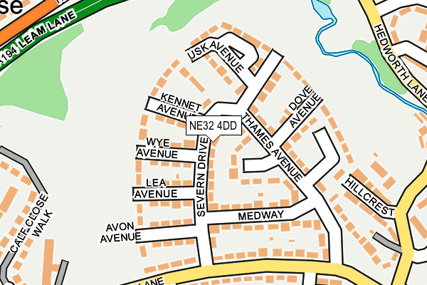
NE32 4DD lies on Severn Drive in Jarrow. NE32 4DD is located in the Fellgate and Hedworth electoral ward, within the metropolitan district of South Tyneside and the English Parliamentary constituency of Jarrow. The Sub Integrated Care Board (ICB) Location is NHS North East and North Cumbria ICB - 00N and the police force is Northumbria. This postcode has been in use since January 1980.


GetTheData
Source: OS OpenMap – Local (Ordnance Survey)
Source: OS VectorMap District (Ordnance Survey)
Licence: Open Government Licence (requires attribution)
| Easting | 433293 |
| Northing | 563045 |
| Latitude | 54.960933 |
| Longitude | -1.481590 |
GetTheData
Source: Open Postcode Geo
Licence: Open Government Licence
| Street | Severn Drive |
| Town/City | Jarrow |
| Country | England |
| Postcode District | NE32 |
➜ See where NE32 is on a map ➜ Where is Jarrow? | |
GetTheData
Source: Land Registry Price Paid Data
Licence: Open Government Licence
Elevation or altitude of NE32 4DD as distance above sea level:
| Metres | Feet | |
|---|---|---|
| Elevation | 20m | 66ft |
Elevation is measured from the approximate centre of the postcode, to the nearest point on an OS contour line from OS Terrain 50, which has contour spacing of ten vertical metres.
➜ How high above sea level am I? Find the elevation of your current position using your device's GPS.
GetTheData
Source: Open Postcode Elevation
Licence: Open Government Licence
| Ward | Fellgate And Hedworth |
| Constituency | Jarrow |
GetTheData
Source: ONS Postcode Database
Licence: Open Government Licence
| Calfclose Lane-trent Avenue (Calfclose Lane) | Hedworth | 197m |
| Calf Close Shops | Hedworth | 231m |
| Calfclose Lane-ribble Walk (Calfclose Lane) | Hedworth | 241m |
| Hedworth Lane-leam Lane (Hedworth Lane) | Primrose | 271m |
| Hedworth Lane-leam Lane (Hedworth Lane) | Primrose | 276m |
| Fellgate (Tyne And Wear Metro Station) (Leam Lane) | Fellgate | 479m |
| Brockley Whins (Tyne And Wear Metro Station) (Station Road) | Brockley Whins | 1,306m |
| Brockley Whins Station | 1.3km |
| East Boldon Station | 4.2km |
| Heworth Station | 4.9km |
GetTheData
Source: NaPTAN
Licence: Open Government Licence
| Percentage of properties with Next Generation Access | 100.0% |
| Percentage of properties with Superfast Broadband | 100.0% |
| Percentage of properties with Ultrafast Broadband | 100.0% |
| Percentage of properties with Full Fibre Broadband | 0.0% |
Superfast Broadband is between 30Mbps and 300Mbps
Ultrafast Broadband is > 300Mbps
| Median download speed | 48.9Mbps |
| Average download speed | 51.4Mbps |
| Maximum download speed | 100.00Mbps |
| Median upload speed | 7.5Mbps |
| Average upload speed | 5.4Mbps |
| Maximum upload speed | 7.94Mbps |
| Percentage of properties unable to receive 2Mbps | 0.0% |
| Percentage of properties unable to receive 5Mbps | 0.0% |
| Percentage of properties unable to receive 10Mbps | 0.0% |
| Percentage of properties unable to receive 30Mbps | 0.0% |
GetTheData
Source: Ofcom
Licence: Ofcom Terms of Use (requires attribution)
Estimated total energy consumption in NE32 4DD by fuel type, 2015.
| Consumption (kWh) | 76,686 |
|---|---|
| Meter count | 12 |
| Mean (kWh/meter) | 6,391 |
| Median (kWh/meter) | 5,638 |
| Consumption (kWh) | 18,468 |
|---|---|
| Meter count | 11 |
| Mean (kWh/meter) | 1,679 |
| Median (kWh/meter) | 1,485 |
GetTheData
Source: Postcode level gas estimates: 2015 (experimental)
Source: Postcode level electricity estimates: 2015 (experimental)
Licence: Open Government Licence
GetTheData
Source: ONS Postcode Database
Licence: Open Government Licence


➜ Get more ratings from the Food Standards Agency
GetTheData
Source: Food Standards Agency
Licence: FSA terms & conditions
| Last Collection | |||
|---|---|---|---|
| Location | Mon-Fri | Sat | Distance |
| Calf Close Lane | 17:15 | 10:30 | 251m |
| Kirkstone Avenue | 17:15 | 10:30 | 299m |
| The Hollow | 17:00 | 10:30 | 545m |
GetTheData
Source: Dracos
Licence: Creative Commons Attribution-ShareAlike
The below table lists the International Territorial Level (ITL) codes (formerly Nomenclature of Territorial Units for Statistics (NUTS) codes) and Local Administrative Units (LAU) codes for NE32 4DD:
| ITL 1 Code | Name |
|---|---|
| TLC | North East (England) |
| ITL 2 Code | Name |
| TLC2 | Northumberland, and Tyne and Wear |
| ITL 3 Code | Name |
| TLC22 | Tyneside |
| LAU 1 Code | Name |
| E08000023 | South Tyneside |
GetTheData
Source: ONS Postcode Directory
Licence: Open Government Licence
The below table lists the Census Output Area (OA), Lower Layer Super Output Area (LSOA), and Middle Layer Super Output Area (MSOA) for NE32 4DD:
| Code | Name | |
|---|---|---|
| OA | E00043826 | |
| LSOA | E01008632 | South Tyneside 017B |
| MSOA | E02001784 | South Tyneside 017 |
GetTheData
Source: ONS Postcode Directory
Licence: Open Government Licence
| NE32 4DB | Kennet Avenue | 64m |
| NE32 4BZ | Wye Avenue | 64m |
| NE32 4BX | Lea Avenue | 87m |
| NE32 4DS | Thames Avenue | 104m |
| NE32 4DE | Thames Avenue | 108m |
| NE32 4DA | Ribble Walk | 110m |
| NE32 4DH | Usk Avenue | 114m |
| NE32 4DW | Dove Avenue | 131m |
| NE32 4DR | Medway | 136m |
| NE32 4BT | Ribble Walk | 142m |
GetTheData
Source: Open Postcode Geo; Land Registry Price Paid Data
Licence: Open Government Licence