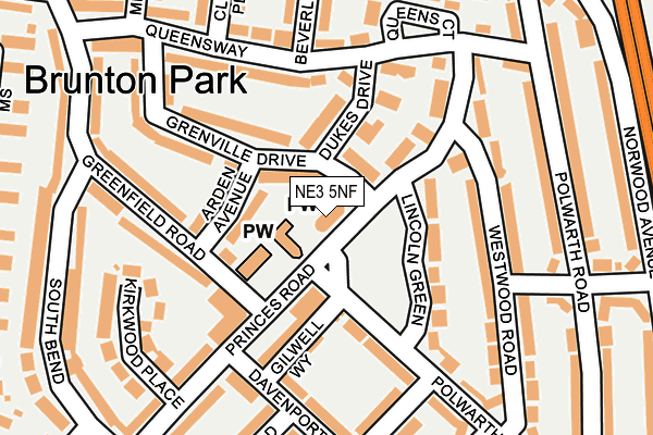
NE3 5NF is located in the Parklands electoral ward, within the metropolitan district of Newcastle upon Tyne and the English Parliamentary constituency of Newcastle upon Tyne North. The Sub Integrated Care Board (ICB) Location is NHS North East and North Cumbria ICB - 13T and the police force is Northumbria. This postcode has been in use since December 2005.


GetTheData
Source: OS OpenMap – Local (Ordnance Survey)
Source: OS VectorMap District (Ordnance Survey)
Licence: Open Government Licence (requires attribution)
| Easting | 423896 |
| Northing | 570316 |
| Latitude | 55.026814 |
| Longitude | -1.627750 |
GetTheData
Source: Open Postcode Geo
Licence: Open Government Licence
| Country | England |
| Postcode District | NE3 |
➜ See where NE3 is on a map ➜ Where is Newcastle upon Tyne? | |
GetTheData
Source: Land Registry Price Paid Data
Licence: Open Government Licence
Elevation or altitude of NE3 5NF as distance above sea level:
| Metres | Feet | |
|---|---|---|
| Elevation | 60m | 197ft |
Elevation is measured from the approximate centre of the postcode, to the nearest point on an OS contour line from OS Terrain 50, which has contour spacing of ten vertical metres.
➜ How high above sea level am I? Find the elevation of your current position using your device's GPS.
GetTheData
Source: Open Postcode Elevation
Licence: Open Government Licence
| Ward | Parklands |
| Constituency | Newcastle Upon Tyne North |
GetTheData
Source: ONS Postcode Database
Licence: Open Government Licence
| Brunton Park Polwarth Drive (Polwarth Drive) | Gosforth | 58m |
| Great North Road-brunton Lane (Great North Road) | Gosforth | 353m |
| Great North Road-norwood Avenue (Gt North Road-norwood Ave) | Gosforth | 363m |
| Brunton Lane-farm Cottages (Brunton Lane) | Great Park | 373m |
| Great North Road-norwood Avenue (Gt North Road) | Gosforth | 385m |
| Wansbeck Road (Tyne And Wear Metro Station) (Wansbeck Road North) | Coxlodge | 1,476m |
| Fawdon (Tyne And Wear Metro Station) (Fawdon Lane) | Fawdon | 1,812m |
GetTheData
Source: NaPTAN
Licence: Open Government Licence
GetTheData
Source: ONS Postcode Database
Licence: Open Government Licence

➜ Get more ratings from the Food Standards Agency
GetTheData
Source: Food Standards Agency
Licence: FSA terms & conditions
| Last Collection | |||
|---|---|---|---|
| Location | Mon-Fri | Sat | Distance |
| Brunton Park Post Office | 17:45 | 12:00 | 103m |
| Whitebridge | 17:30 | 12:00 | 1,093m |
| Broadway West | 17:30 | 12:00 | 1,133m |
GetTheData
Source: Dracos
Licence: Creative Commons Attribution-ShareAlike
The below table lists the International Territorial Level (ITL) codes (formerly Nomenclature of Territorial Units for Statistics (NUTS) codes) and Local Administrative Units (LAU) codes for NE3 5NF:
| ITL 1 Code | Name |
|---|---|
| TLC | North East (England) |
| ITL 2 Code | Name |
| TLC2 | Northumberland, and Tyne and Wear |
| ITL 3 Code | Name |
| TLC22 | Tyneside |
| LAU 1 Code | Name |
| E08000021 | Newcastle upon Tyne |
GetTheData
Source: ONS Postcode Directory
Licence: Open Government Licence
The below table lists the Census Output Area (OA), Lower Layer Super Output Area (LSOA), and Middle Layer Super Output Area (MSOA) for NE3 5NF:
| Code | Name | |
|---|---|---|
| OA | E00042174 | |
| LSOA | E01008309 | Newcastle upon Tyne 002A |
| MSOA | E02001709 | Newcastle upon Tyne 002 |
GetTheData
Source: ONS Postcode Directory
Licence: Open Government Licence
| NE3 5TS | Arden Avenue | 74m |
| NE3 5TT | Princes Road | 86m |
| NE3 5PA | Grenville Drive | 118m |
| NE3 5TQ | Greenfield Road | 124m |
| NE3 5NT | Dukes Drive | 126m |
| NE3 5AH | Davenport Drive | 131m |
| NE3 5PB | Lincoln Green | 139m |
| NE3 5AU | Kirkwood Place | 157m |
| NE3 5NP | Princes Road | 162m |
| NE3 5NJ | Polwarth Drive | 163m |
GetTheData
Source: Open Postcode Geo; Land Registry Price Paid Data
Licence: Open Government Licence