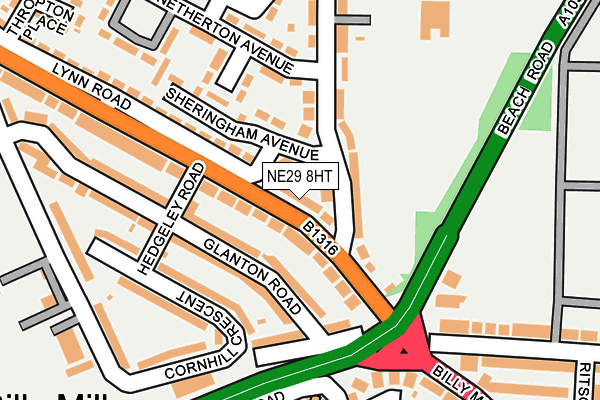
NE29 8HT lies on Lynn Road in North Shields. NE29 8HT is located in the Collingwood electoral ward, within the metropolitan district of North Tyneside and the English Parliamentary constituency of Tynemouth. The Sub Integrated Care Board (ICB) Location is NHS North East and North Cumbria ICB - 99C and the police force is Northumbria. This postcode has been in use since January 1980.


GetTheData
Source: OS OpenMap – Local (Ordnance Survey)
Source: OS VectorMap District (Ordnance Survey)
Licence: Open Government Licence (requires attribution)
| Easting | 433957 |
| Northing | 569235 |
| Latitude | 55.016511 |
| Longitude | -1.470490 |
GetTheData
Source: Open Postcode Geo
Licence: Open Government Licence
| Street | Lynn Road |
| Town/City | North Shields |
| Country | England |
| Postcode District | NE29 |
➜ See where NE29 is on a map ➜ Where is Tynemouth? | |
GetTheData
Source: Land Registry Price Paid Data
Licence: Open Government Licence
Elevation or altitude of NE29 8HT as distance above sea level:
| Metres | Feet | |
|---|---|---|
| Elevation | 60m | 197ft |
Elevation is measured from the approximate centre of the postcode, to the nearest point on an OS contour line from OS Terrain 50, which has contour spacing of ten vertical metres.
➜ How high above sea level am I? Find the elevation of your current position using your device's GPS.
GetTheData
Source: Open Postcode Elevation
Licence: Open Government Licence
| Ward | Collingwood |
| Constituency | Tynemouth |
GetTheData
Source: ONS Postcode Database
Licence: Open Government Licence
18, LYNN ROAD, NORTH SHIELDS, NE29 8HT 2024 4 APR £312,000 |
28, LYNN ROAD, NORTH SHIELDS, NE29 8HT 2016 15 JAN £153,000 |
22, LYNN ROAD, NORTH SHIELDS, NE29 8HT 2015 9 JAN £160,500 |
22, LYNN ROAD, NORTH SHIELDS, NE29 8HT 2010 20 AUG £167,000 |
22, LYNN ROAD, NORTH SHIELDS, NE29 8HT 2006 13 JUL £175,000 |
22, LYNN ROAD, NORTH SHIELDS, NE29 8HT 2003 16 DEC £140,000 |
24, LYNN ROAD, NORTH SHIELDS, NE29 8HT 2002 6 DEC £120,000 |
GetTheData
Source: HM Land Registry Price Paid Data
Licence: Contains HM Land Registry data © Crown copyright and database right 2025. This data is licensed under the Open Government Licence v3.0.
| Lynn Road - Hedgeley Road (Lynn Road) | Billy Mill | 86m |
| Lynn Road - Heaton Terrace (Lynn Road) | Billy Mill | 96m |
| Morwick Road | Billy Mill | 104m |
| Morwick Road-netherton Avenue (Morwick Road) | Billy Mill | 138m |
| Coast Road - Glanton Road (Coast Road) | Billy Mill | 152m |
| North Shields (Tyne And Wear Metro Station) (Railway Terrace) | North Shields | 1,671m |
GetTheData
Source: NaPTAN
Licence: Open Government Licence
| Percentage of properties with Next Generation Access | 100.0% |
| Percentage of properties with Superfast Broadband | 100.0% |
| Percentage of properties with Ultrafast Broadband | 100.0% |
| Percentage of properties with Full Fibre Broadband | 0.0% |
Superfast Broadband is between 30Mbps and 300Mbps
Ultrafast Broadband is > 300Mbps
| Percentage of properties unable to receive 2Mbps | 0.0% |
| Percentage of properties unable to receive 5Mbps | 0.0% |
| Percentage of properties unable to receive 10Mbps | 0.0% |
| Percentage of properties unable to receive 30Mbps | 0.0% |
GetTheData
Source: Ofcom
Licence: Ofcom Terms of Use (requires attribution)
Estimated total energy consumption in NE29 8HT by fuel type, 2015.
| Consumption (kWh) | 86,491 |
|---|---|
| Meter count | 6 |
| Mean (kWh/meter) | 14,415 |
| Median (kWh/meter) | 13,525 |
| Consumption (kWh) | 13,014 |
|---|---|
| Meter count | 6 |
| Mean (kWh/meter) | 2,169 |
| Median (kWh/meter) | 2,570 |
GetTheData
Source: Postcode level gas estimates: 2015 (experimental)
Source: Postcode level electricity estimates: 2015 (experimental)
Licence: Open Government Licence
GetTheData
Source: ONS Postcode Database
Licence: Open Government Licence


➜ Get more ratings from the Food Standards Agency
GetTheData
Source: Food Standards Agency
Licence: FSA terms & conditions
| Last Collection | |||
|---|---|---|---|
| Location | Mon-Fri | Sat | Distance |
| Norham Road North | 16:45 | 12:15 | 161m |
| Lynn Road | 16:15 | 12:30 | 432m |
| Monkswood | 16:00 | 11:45 | 869m |
GetTheData
Source: Dracos
Licence: Creative Commons Attribution-ShareAlike
The below table lists the International Territorial Level (ITL) codes (formerly Nomenclature of Territorial Units for Statistics (NUTS) codes) and Local Administrative Units (LAU) codes for NE29 8HT:
| ITL 1 Code | Name |
|---|---|
| TLC | North East (England) |
| ITL 2 Code | Name |
| TLC2 | Northumberland, and Tyne and Wear |
| ITL 3 Code | Name |
| TLC22 | Tyneside |
| LAU 1 Code | Name |
| E08000022 | North Tyneside |
GetTheData
Source: ONS Postcode Directory
Licence: Open Government Licence
The below table lists the Census Output Area (OA), Lower Layer Super Output Area (LSOA), and Middle Layer Super Output Area (MSOA) for NE29 8HT:
| Code | Name | |
|---|---|---|
| OA | E00043090 | |
| LSOA | E01008487 | North Tyneside 020B |
| MSOA | E02001757 | North Tyneside 020 |
GetTheData
Source: ONS Postcode Directory
Licence: Open Government Licence
| NE29 8HU | Sheringham Avenue | 30m |
| NE29 8HW | Lynn Road | 38m |
| NE29 8HX | Sheringham Avenue | 55m |
| NE29 8HZ | Morwick Road | 83m |
| NE29 8JA | Morwick Road | 96m |
| NE29 8LJ | Glanton Road | 98m |
| NE29 8HY | Sheringham Avenue | 102m |
| NE29 8HN | Lynn Road | 102m |
| NE29 8LH | Hedgeley Road | 112m |
| NE29 8JJ | Whitton Gardens | 128m |
GetTheData
Source: Open Postcode Geo; Land Registry Price Paid Data
Licence: Open Government Licence