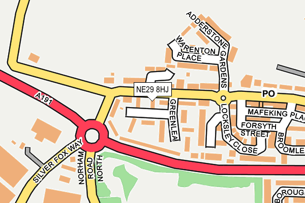
NE29 8HJ lies on Greenlea in North Shields. NE29 8HJ is located in the Collingwood electoral ward, within the metropolitan district of North Tyneside and the English Parliamentary constituency of Tynemouth. The Sub Integrated Care Board (ICB) Location is NHS North East and North Cumbria ICB - 99C and the police force is Northumbria. This postcode has been in use since January 1980.


GetTheData
Source: OS OpenMap – Local (Ordnance Survey)
Source: OS VectorMap District (Ordnance Survey)
Licence: Open Government Licence (requires attribution)
| Easting | 432600 |
| Northing | 570164 |
| Latitude | 55.024949 |
| Longitude | -1.491605 |
GetTheData
Source: Open Postcode Geo
Licence: Open Government Licence
| Street | Greenlea |
| Town/City | North Shields |
| Country | England |
| Postcode District | NE29 |
➜ See where NE29 is on a map ➜ Where is New York? | |
GetTheData
Source: Land Registry Price Paid Data
Licence: Open Government Licence
Elevation or altitude of NE29 8HJ as distance above sea level:
| Metres | Feet | |
|---|---|---|
| Elevation | 70m | 230ft |
Elevation is measured from the approximate centre of the postcode, to the nearest point on an OS contour line from OS Terrain 50, which has contour spacing of ten vertical metres.
➜ How high above sea level am I? Find the elevation of your current position using your device's GPS.
GetTheData
Source: Open Postcode Elevation
Licence: Open Government Licence
| Ward | Collingwood |
| Constituency | Tynemouth |
GetTheData
Source: ONS Postcode Database
Licence: Open Government Licence
| New York Road-greenlea (New York Road) | New York | 23m |
| New York Road-adderstone Gardens (New York Road) | New York | 105m |
| New York Road-the Wheatsheaf (New York Road) | New York | 177m |
| New York Road - Coronation Terrace (New York Road) | New York | 241m |
| New York Road - Coronation Terrace (New York Road) | New York | 259m |
| Shiremoor (Tyne And Wear Metro Station) (Park Lane) | Shiremoor | 1,568m |
GetTheData
Source: NaPTAN
Licence: Open Government Licence
| Percentage of properties with Next Generation Access | 100.0% |
| Percentage of properties with Superfast Broadband | 100.0% |
| Percentage of properties with Ultrafast Broadband | 100.0% |
| Percentage of properties with Full Fibre Broadband | 0.0% |
Superfast Broadband is between 30Mbps and 300Mbps
Ultrafast Broadband is > 300Mbps
| Median download speed | 100.0Mbps |
| Average download speed | 127.9Mbps |
| Maximum download speed | 350.00Mbps |
| Median upload speed | 0.8Mbps |
| Average upload speed | 0.7Mbps |
| Maximum upload speed | 0.78Mbps |
| Percentage of properties unable to receive 2Mbps | 0.0% |
| Percentage of properties unable to receive 5Mbps | 0.0% |
| Percentage of properties unable to receive 10Mbps | 0.0% |
| Percentage of properties unable to receive 30Mbps | 0.0% |
GetTheData
Source: Ofcom
Licence: Ofcom Terms of Use (requires attribution)
Estimated total energy consumption in NE29 8HJ by fuel type, 2015.
| Consumption (kWh) | 160,582 |
|---|---|
| Meter count | 14 |
| Mean (kWh/meter) | 11,470 |
| Median (kWh/meter) | 10,890 |
| Consumption (kWh) | 52,015 |
|---|---|
| Meter count | 14 |
| Mean (kWh/meter) | 3,715 |
| Median (kWh/meter) | 3,604 |
GetTheData
Source: Postcode level gas estimates: 2015 (experimental)
Source: Postcode level electricity estimates: 2015 (experimental)
Licence: Open Government Licence
GetTheData
Source: ONS Postcode Database
Licence: Open Government Licence


➜ Get more ratings from the Food Standards Agency
GetTheData
Source: Food Standards Agency
Licence: FSA terms & conditions
| Last Collection | |||
|---|---|---|---|
| Location | Mon-Fri | Sat | Distance |
| Malvern Rod | 16:30 | 12:45 | 537m |
| North Tyneside Delivery Office | 18:45 | 12:45 | 581m |
| Sherwood | 17:45 | 11:00 | 707m |
GetTheData
Source: Dracos
Licence: Creative Commons Attribution-ShareAlike
The below table lists the International Territorial Level (ITL) codes (formerly Nomenclature of Territorial Units for Statistics (NUTS) codes) and Local Administrative Units (LAU) codes for NE29 8HJ:
| ITL 1 Code | Name |
|---|---|
| TLC | North East (England) |
| ITL 2 Code | Name |
| TLC2 | Northumberland, and Tyne and Wear |
| ITL 3 Code | Name |
| TLC22 | Tyneside |
| LAU 1 Code | Name |
| E08000022 | North Tyneside |
GetTheData
Source: ONS Postcode Directory
Licence: Open Government Licence
The below table lists the Census Output Area (OA), Lower Layer Super Output Area (LSOA), and Middle Layer Super Output Area (MSOA) for NE29 8HJ:
| Code | Name | |
|---|---|---|
| OA | E00043096 | |
| LSOA | E01008488 | North Tyneside 015A |
| MSOA | E02001752 | North Tyneside 015 |
GetTheData
Source: ONS Postcode Directory
Licence: Open Government Licence
| NE29 8HH | Greenlea | 42m |
| NE29 8EL | New York Road | 46m |
| NE29 8HQ | Greenlea | 65m |
| NE29 8ES | Warenton Place | 126m |
| NE29 8EN | Locksley Close | 185m |
| NE29 8ER | Adderstone Gardens | 191m |
| NE29 8ED | Forsyth Street | 209m |
| NE29 8EA | Brookland Terrace | 232m |
| NE29 8EP | Brookland Terrace | 265m |
| NE27 0QH | Silver Fox Way | 268m |
GetTheData
Source: Open Postcode Geo; Land Registry Price Paid Data
Licence: Open Government Licence