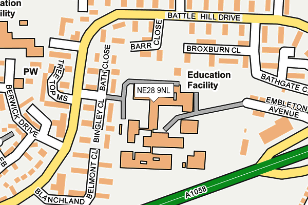
NE28 9NL is located in the Battle Hill electoral ward, within the metropolitan district of North Tyneside and the English Parliamentary constituency of North Tyneside. The Sub Integrated Care Board (ICB) Location is NHS North East and North Cumbria ICB - 99C and the police force is Northumbria. This postcode has been in use since January 1980.


GetTheData
Source: OS OpenMap – Local (Ordnance Survey)
Source: OS VectorMap District (Ordnance Survey)
Licence: Open Government Licence (requires attribution)
| Easting | 431194 |
| Northing | 568229 |
| Latitude | 55.007651 |
| Longitude | -1.513807 |
GetTheData
Source: Open Postcode Geo
Licence: Open Government Licence
| Country | England |
| Postcode District | NE28 |
➜ See where NE28 is on a map ➜ Where is Wallsend? | |
GetTheData
Source: Land Registry Price Paid Data
Licence: Open Government Licence
Elevation or altitude of NE28 9NL as distance above sea level:
| Metres | Feet | |
|---|---|---|
| Elevation | 50m | 164ft |
Elevation is measured from the approximate centre of the postcode, to the nearest point on an OS contour line from OS Terrain 50, which has contour spacing of ten vertical metres.
➜ How high above sea level am I? Find the elevation of your current position using your device's GPS.
GetTheData
Source: Open Postcode Elevation
Licence: Open Government Licence
| Ward | Battle Hill |
| Constituency | North Tyneside |
GetTheData
Source: ONS Postcode Database
Licence: Open Government Licence
| Tyne Met Coast Road College (Battle Hill Drive) | Battle Hill | 169m |
| Battle Hill Drive-bodmin Close (Battle Hill Drive) | Battle Hill | 174m |
| Battle Hill Drive-bodmin Close (Battle Hill Drive) | Battle Hill | 188m |
| Battle Hill-belmont Close (Battle Hill Drive) | Battle Hill | 254m |
| Coast Road-embleton Avenue (Coast Road) | Battle Hill | 264m |
| Howdon (Tyne And Wear Metro Station) (Howdon Lane) | Howdon | 1,822m |
GetTheData
Source: NaPTAN
Licence: Open Government Licence
GetTheData
Source: ONS Postcode Database
Licence: Open Government Licence


➜ Get more ratings from the Food Standards Agency
GetTheData
Source: Food Standards Agency
Licence: FSA terms & conditions
| Last Collection | |||
|---|---|---|---|
| Location | Mon-Fri | Sat | Distance |
| High Howdon Post Office | 17:45 | 11:00 | 1,425m |
| High View | 16:15 | 11:15 | 1,541m |
| South Terrace | 16:15 | 11:00 | 1,624m |
GetTheData
Source: Dracos
Licence: Creative Commons Attribution-ShareAlike
The below table lists the International Territorial Level (ITL) codes (formerly Nomenclature of Territorial Units for Statistics (NUTS) codes) and Local Administrative Units (LAU) codes for NE28 9NL:
| ITL 1 Code | Name |
|---|---|
| TLC | North East (England) |
| ITL 2 Code | Name |
| TLC2 | Northumberland, and Tyne and Wear |
| ITL 3 Code | Name |
| TLC22 | Tyneside |
| LAU 1 Code | Name |
| E08000022 | North Tyneside |
GetTheData
Source: ONS Postcode Directory
Licence: Open Government Licence
The below table lists the Census Output Area (OA), Lower Layer Super Output Area (LSOA), and Middle Layer Super Output Area (MSOA) for NE28 9NL:
| Code | Name | |
|---|---|---|
| OA | E00042967 | |
| LSOA | E01008462 | North Tyneside 024A |
| MSOA | E02001761 | North Tyneside 024 |
GetTheData
Source: ONS Postcode Directory
Licence: Open Government Licence
| NE28 9DY | Bingley Close | 91m |
| NE28 9SZ | Barr Close | 126m |
| NE28 9DZ | Bath Close | 127m |
| NE28 9SS | Broxburn Close | 147m |
| NE28 9EH | Tree Top Mews | 183m |
| NE28 9DX | Belmont Close | 188m |
| NE28 9ST | Broxburn Close | 200m |
| NE28 9SF | Bodmin Close | 202m |
| NE28 9SG | Bodmin Close | 209m |
| NE28 9SA | Bromsgrove Close | 223m |
GetTheData
Source: Open Postcode Geo; Land Registry Price Paid Data
Licence: Open Government Licence