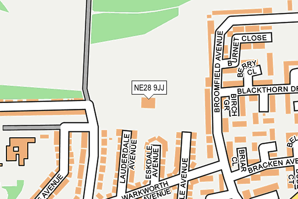
NE28 9JJ is located in the Battle Hill electoral ward, within the metropolitan district of North Tyneside and the English Parliamentary constituency of North Tyneside. The Sub Integrated Care Board (ICB) Location is NHS North East and North Cumbria ICB - 99C and the police force is Northumbria. This postcode has been in use since January 1980.


GetTheData
Source: OS OpenMap – Local (Ordnance Survey)
Source: OS VectorMap District (Ordnance Survey)
Licence: Open Government Licence (requires attribution)
| Easting | 430070 |
| Northing | 568135 |
| Latitude | 55.006876 |
| Longitude | -1.531390 |
GetTheData
Source: Open Postcode Geo
Licence: Open Government Licence
| Country | England |
| Postcode District | NE28 |
➜ See where NE28 is on a map ➜ Where is Wallsend? | |
GetTheData
Source: Land Registry Price Paid Data
Licence: Open Government Licence
Elevation or altitude of NE28 9JJ as distance above sea level:
| Metres | Feet | |
|---|---|---|
| Elevation | 50m | 164ft |
Elevation is measured from the approximate centre of the postcode, to the nearest point on an OS contour line from OS Terrain 50, which has contour spacing of ten vertical metres.
➜ How high above sea level am I? Find the elevation of your current position using your device's GPS.
GetTheData
Source: Open Postcode Elevation
Licence: Open Government Licence
| Ward | Battle Hill |
| Constituency | North Tyneside |
GetTheData
Source: ONS Postcode Database
Licence: Open Government Licence
| Mullen Road - Allendale Avenue (Mullen Road) | High Farm | 311m |
| Burnside High School-high Farm Site (Rae Avenue) | High Farm | 338m |
| Battle Hill Drive-broomfield Avenue (Battle Hill Drive) | Battle Hill | 346m |
| Battle Hill Drive-broomfield Avenue (Battle Hill Drive) | Battle Hill | 362m |
| Broomfield Avenue (Broomfield Avenue) | Battle Hill | 363m |
| Manors Station | 6km |
GetTheData
Source: NaPTAN
Licence: Open Government Licence
GetTheData
Source: ONS Postcode Database
Licence: Open Government Licence


➜ Get more ratings from the Food Standards Agency
GetTheData
Source: Food Standards Agency
Licence: FSA terms & conditions
| Last Collection | |||
|---|---|---|---|
| Location | Mon-Fri | Sat | Distance |
| High View | 16:15 | 11:15 | 804m |
| Kensington Gardens | 16:30 | 11:30 | 1,384m |
| Church Bank | 18:30 | 11:00 | 1,696m |
GetTheData
Source: Dracos
Licence: Creative Commons Attribution-ShareAlike
The below table lists the International Territorial Level (ITL) codes (formerly Nomenclature of Territorial Units for Statistics (NUTS) codes) and Local Administrative Units (LAU) codes for NE28 9JJ:
| ITL 1 Code | Name |
|---|---|
| TLC | North East (England) |
| ITL 2 Code | Name |
| TLC2 | Northumberland, and Tyne and Wear |
| ITL 3 Code | Name |
| TLC22 | Tyneside |
| LAU 1 Code | Name |
| E08000022 | North Tyneside |
GetTheData
Source: ONS Postcode Directory
Licence: Open Government Licence
The below table lists the Census Output Area (OA), Lower Layer Super Output Area (LSOA), and Middle Layer Super Output Area (MSOA) for NE28 9JJ:
| Code | Name | |
|---|---|---|
| OA | E00042932 | |
| LSOA | E01008464 | North Tyneside 024C |
| MSOA | E02001761 | North Tyneside 024 |
GetTheData
Source: ONS Postcode Directory
Licence: Open Government Licence
| NE28 9JB | Dinsdale Avenue | 114m |
| NE28 9JA | Eskdale Avenue | 119m |
| NE28 9HX | Lauderdale Avenue | 136m |
| NE28 9AD | Broomfield Avenue | 165m |
| NE28 9HZ | Warkworth Avenue | 185m |
| NE28 9JH | Kings Road North | 190m |
| NE28 9BA | Birch Grove | 190m |
| NE28 9BE | Briar Close | 202m |
| NE28 9AH | Blackthorn Drive | 211m |
| NE28 9AE | Broomfield Avenue | 212m |
GetTheData
Source: Open Postcode Geo; Land Registry Price Paid Data
Licence: Open Government Licence