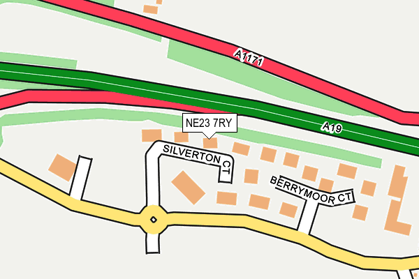
NE23 7RY is located in the Cramlington South East electoral ward, within the unitary authority of Northumberland and the English Parliamentary constituency of Blyth Valley. The Sub Integrated Care Board (ICB) Location is NHS North East and North Cumbria ICB - 00L and the police force is Northumbria. This postcode has been in use since August 2008.


GetTheData
Source: OS OpenMap – Local (Ordnance Survey)
Source: OS VectorMap District (Ordnance Survey)
Licence: Open Government Licence (requires attribution)
| Easting | 426555 |
| Northing | 574684 |
| Latitude | 55.065923 |
| Longitude | -1.585739 |
GetTheData
Source: Open Postcode Geo
Licence: Open Government Licence
| Country | England |
| Postcode District | NE23 |
➜ See where NE23 is on a map ➜ Where is Dudley? | |
GetTheData
Source: Land Registry Price Paid Data
Licence: Open Government Licence
Elevation or altitude of NE23 7RY as distance above sea level:
| Metres | Feet | |
|---|---|---|
| Elevation | 50m | 164ft |
Elevation is measured from the approximate centre of the postcode, to the nearest point on an OS contour line from OS Terrain 50, which has contour spacing of ten vertical metres.
➜ How high above sea level am I? Find the elevation of your current position using your device's GPS.
GetTheData
Source: Open Postcode Elevation
Licence: Open Government Licence
| Ward | Cramlington South East |
| Constituency | Blyth Valley |
GetTheData
Source: ONS Postcode Database
Licence: Open Government Licence
| Dudley Lane | Northumberland Business Park | 393m |
| Moor Farm Roundabout (B1505) | Southfield | 408m |
| Moor Farm Roundabout (B1505) | Southfield | 410m |
| Dudley Lane | Northumberland Business Park | 422m |
| Barns Park (Dudley Lane) | Southfield | 467m |
| Cramlington Station | 2.6km |
GetTheData
Source: NaPTAN
Licence: Open Government Licence
GetTheData
Source: ONS Postcode Database
Licence: Open Government Licence


➜ Get more ratings from the Food Standards Agency
GetTheData
Source: Food Standards Agency
Licence: FSA terms & conditions
| Last Collection | |||
|---|---|---|---|
| Location | Mon-Fri | Sat | Distance |
| Apex Business Village | 17:45 | 12:00 | 336m |
| Apex Business Village | 17:45 | 337m | |
| Winburgh Avenue | 16:00 | 12:00 | 623m |
GetTheData
Source: Dracos
Licence: Creative Commons Attribution-ShareAlike
The below table lists the International Territorial Level (ITL) codes (formerly Nomenclature of Territorial Units for Statistics (NUTS) codes) and Local Administrative Units (LAU) codes for NE23 7RY:
| ITL 1 Code | Name |
|---|---|
| TLC | North East (England) |
| ITL 2 Code | Name |
| TLC2 | Northumberland, and Tyne and Wear |
| ITL 3 Code | Name |
| TLC21 | Northumberland |
| LAU 1 Code | Name |
| E06000057 | Northumberland |
GetTheData
Source: ONS Postcode Directory
Licence: Open Government Licence
The below table lists the Census Output Area (OA), Lower Layer Super Output Area (LSOA), and Middle Layer Super Output Area (MSOA) for NE23 7RY:
| Code | Name | |
|---|---|---|
| OA | E00139478 | |
| LSOA | E01027406 | Northumberland 031B |
| MSOA | E02005718 | Northumberland 031 |
GetTheData
Source: ONS Postcode Directory
Licence: Open Government Licence
| NE23 7RZ | Berrymoor Court | 180m |
| NE23 7JG | 218m | |
| NE23 7BF | 398m | |
| NE23 6PE | Welbury Way | 439m |
| NE23 6NT | Windburgh Drive | 475m |
| NE23 6PD | Welbury Way | 477m |
| NE23 6NS | Windburgh Drive | 480m |
| NE23 6NL | Greystoke Place | 488m |
| NE23 7QL | Hedgefield View | 496m |
| NE23 7QT | Orange Grove | 501m |
GetTheData
Source: Open Postcode Geo; Land Registry Price Paid Data
Licence: Open Government Licence