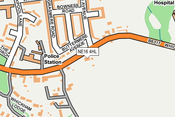
NE16 4HL lies on Front Street in Whickham, Newcastle Upon Tyne. NE16 4HL is located in the Dunston Hill and Whickham East electoral ward, within the metropolitan district of Gateshead and the English Parliamentary constituency of Blaydon. The Sub Integrated Care Board (ICB) Location is NHS North East and North Cumbria ICB - 13T and the police force is Northumbria. This postcode has been in use since January 1980.


GetTheData
Source: OS OpenMap – Local (Ordnance Survey)
Source: OS VectorMap District (Ordnance Survey)
Licence: Open Government Licence (requires attribution)
| Easting | 421574 |
| Northing | 561201 |
| Latitude | 54.945005 |
| Longitude | -1.664741 |
GetTheData
Source: Open Postcode Geo
Licence: Open Government Licence
| Street | Front Street |
| Locality | Whickham |
| Town/City | Newcastle Upon Tyne |
| Country | England |
| Postcode District | NE16 |
➜ See where NE16 is on a map ➜ Where is Whickham? | |
GetTheData
Source: Land Registry Price Paid Data
Licence: Open Government Licence
Elevation or altitude of NE16 4HL as distance above sea level:
| Metres | Feet | |
|---|---|---|
| Elevation | 110m | 361ft |
Elevation is measured from the approximate centre of the postcode, to the nearest point on an OS contour line from OS Terrain 50, which has contour spacing of ten vertical metres.
➜ How high above sea level am I? Find the elevation of your current position using your device's GPS.
GetTheData
Source: Open Postcode Elevation
Licence: Open Government Licence
| Ward | Dunston Hill And Whickham East |
| Constituency | Blaydon |
GetTheData
Source: ONS Postcode Database
Licence: Open Government Licence
2015 17 MAR £765,000 |
2004 29 NOV £390,000 |
1996 8 MAR £190,000 |
GetTheData
Source: HM Land Registry Price Paid Data
Licence: Contains HM Land Registry data © Crown copyright and database right 2025. This data is licensed under the Open Government Licence v3.0.
| Whickham Highway-coniston Avenue (Whickham Highway) | Whickham | 39m |
| Whickham Highway-coniston Avenue (Whickham Highway) | Whickham | 62m |
| St Mary's Rc Primary School (Duckpool Lane) | Whickham | 284m |
| Front Street - Dockendale Lane (Front Street) | Whickham | 338m |
| Front Street- Dockendale Lane (Front Street) | Whickham | 371m |
| Metrocentre Station | 1.5km |
| Dunston Station | 1.6km |
| Blaydon Station | 3.8km |
GetTheData
Source: NaPTAN
Licence: Open Government Licence
| Percentage of properties with Next Generation Access | 100.0% |
| Percentage of properties with Superfast Broadband | 100.0% |
| Percentage of properties with Ultrafast Broadband | 0.0% |
| Percentage of properties with Full Fibre Broadband | 0.0% |
Superfast Broadband is between 30Mbps and 300Mbps
Ultrafast Broadband is > 300Mbps
| Percentage of properties unable to receive 2Mbps | 0.0% |
| Percentage of properties unable to receive 5Mbps | 0.0% |
| Percentage of properties unable to receive 10Mbps | 0.0% |
| Percentage of properties unable to receive 30Mbps | 0.0% |
GetTheData
Source: Ofcom
Licence: Ofcom Terms of Use (requires attribution)
GetTheData
Source: ONS Postcode Database
Licence: Open Government Licence


➜ Get more ratings from the Food Standards Agency
GetTheData
Source: Food Standards Agency
Licence: FSA terms & conditions
| Last Collection | |||
|---|---|---|---|
| Location | Mon-Fri | Sat | Distance |
| Coniston Avenue | 17:00 | 12:30 | 50m |
| Front Street | 17:15 | 12:30 | 430m |
| Elm Avenue | 16:00 | 10:45 | 580m |
GetTheData
Source: Dracos
Licence: Creative Commons Attribution-ShareAlike
The below table lists the International Territorial Level (ITL) codes (formerly Nomenclature of Territorial Units for Statistics (NUTS) codes) and Local Administrative Units (LAU) codes for NE16 4HL:
| ITL 1 Code | Name |
|---|---|
| TLC | North East (England) |
| ITL 2 Code | Name |
| TLC2 | Northumberland, and Tyne and Wear |
| ITL 3 Code | Name |
| TLC22 | Tyneside |
| LAU 1 Code | Name |
| E08000037 | Gateshead |
GetTheData
Source: ONS Postcode Directory
Licence: Open Government Licence
The below table lists the Census Output Area (OA), Lower Layer Super Output Area (LSOA), and Middle Layer Super Output Area (MSOA) for NE16 4HL:
| Code | Name | |
|---|---|---|
| OA | E00041912 | |
| LSOA | E01008268 | Gateshead 019D |
| MSOA | E02001700 | Gateshead 019 |
GetTheData
Source: ONS Postcode Directory
Licence: Open Government Licence
| NE16 4EX | Buttermere Avenue | 71m |
| NE16 4EY | Derwentwater Gardens | 131m |
| NE16 4HJ | Washingwell Lane | 144m |
| NE16 4ER | Coniston Avenue | 170m |
| NE16 4EU | Grasmere Road | 173m |
| NE16 4HF | Front Street | 188m |
| NE16 4EZ | Bowness Road | 192m |
| NE16 4RT | Washingwell Lane | 211m |
| NE16 4ES | Borrowdale | 239m |
| NE16 4HA | Crawley Gardens | 240m |
GetTheData
Source: Open Postcode Geo; Land Registry Price Paid Data
Licence: Open Government Licence