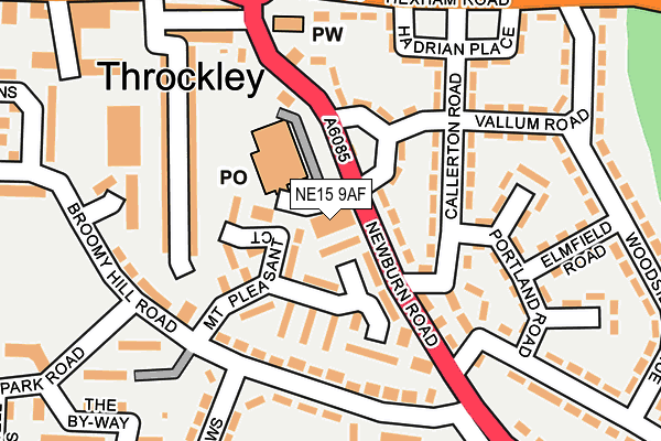
NE15 9AF is located in the Callerton & Throckley electoral ward, within the metropolitan district of Newcastle upon Tyne and the English Parliamentary constituency of Newcastle upon Tyne North. The Sub Integrated Care Board (ICB) Location is NHS North East and North Cumbria ICB - 13T and the police force is Northumbria. This postcode has been in use since January 1980.


GetTheData
Source: OS OpenMap – Local (Ordnance Survey)
Source: OS VectorMap District (Ordnance Survey)
Licence: Open Government Licence (requires attribution)
| Easting | 415898 |
| Northing | 566635 |
| Latitude | 54.994055 |
| Longitude | -1.753062 |
GetTheData
Source: Open Postcode Geo
Licence: Open Government Licence
| Country | England |
| Postcode District | NE15 |
➜ See where NE15 is on a map ➜ Where is Throckley? | |
GetTheData
Source: Land Registry Price Paid Data
Licence: Open Government Licence
Elevation or altitude of NE15 9AF as distance above sea level:
| Metres | Feet | |
|---|---|---|
| Elevation | 70m | 230ft |
Elevation is measured from the approximate centre of the postcode, to the nearest point on an OS contour line from OS Terrain 50, which has contour spacing of ten vertical metres.
➜ How high above sea level am I? Find the elevation of your current position using your device's GPS.
GetTheData
Source: Open Postcode Elevation
Licence: Open Government Licence
| Ward | Callerton & Throckley |
| Constituency | Newcastle Upon Tyne North |
GetTheData
Source: ONS Postcode Database
Licence: Open Government Licence
| Newburn Road - Sainsburys (Newburn Road) | Throckley | 63m |
| Newburn Road-appian Place (Newburn Road) | Throckley | 160m |
| Throckley Roundabout (Newburn Road) | Throckley | 162m |
| Hexham Road-hadrian Place (Hexham Road) | Throckley | 215m |
| Newburn Road-broomy Hill Road (Newburn Road) | Throckley | 233m |
| Blaydon Station | 4.1km |
| Wylam Station | 4.4km |
| Newcastle Airport Metro | 5.4km |
GetTheData
Source: NaPTAN
Licence: Open Government Licence
GetTheData
Source: ONS Postcode Database
Licence: Open Government Licence


➜ Get more ratings from the Food Standards Agency
GetTheData
Source: Food Standards Agency
Licence: FSA terms & conditions
| Last Collection | |||
|---|---|---|---|
| Location | Mon-Fri | Sat | Distance |
| Alston Gardens | 17:30 | 11:00 | 1,397m |
| Kenton Grange | 17:30 | 12:00 | 1,472m |
| Moorcroft Road | 17:30 | 11:30 | 1,983m |
GetTheData
Source: Dracos
Licence: Creative Commons Attribution-ShareAlike
The below table lists the International Territorial Level (ITL) codes (formerly Nomenclature of Territorial Units for Statistics (NUTS) codes) and Local Administrative Units (LAU) codes for NE15 9AF:
| ITL 1 Code | Name |
|---|---|
| TLC | North East (England) |
| ITL 2 Code | Name |
| TLC2 | Northumberland, and Tyne and Wear |
| ITL 3 Code | Name |
| TLC22 | Tyneside |
| LAU 1 Code | Name |
| E08000021 | Newcastle upon Tyne |
GetTheData
Source: ONS Postcode Directory
Licence: Open Government Licence
The below table lists the Census Output Area (OA), Lower Layer Super Output Area (LSOA), and Middle Layer Super Output Area (MSOA) for NE15 9AF:
| Code | Name | |
|---|---|---|
| OA | E00042621 | |
| LSOA | E01008401 | Newcastle upon Tyne 014B |
| MSOA | E02001721 | Newcastle upon Tyne 014 |
GetTheData
Source: ONS Postcode Directory
Licence: Open Government Licence
| NE15 9AD | Newburn Road | 57m |
| NE15 9AZ | Mount Pleasant Court | 62m |
| NE15 9AG | Newburn Road | 105m |
| NE15 9BN | Callerton Road | 107m |
| NE15 9AB | Newburn Road | 121m |
| NE15 9NT | Broomy Hill Road | 138m |
| NE15 9BL | Callerton Road | 140m |
| NE15 9NR | Orchard Terrace | 141m |
| NE15 9NQ | Hilda Terrace | 162m |
| NE15 9BS | Portland Road | 166m |
GetTheData
Source: Open Postcode Geo; Land Registry Price Paid Data
Licence: Open Government Licence