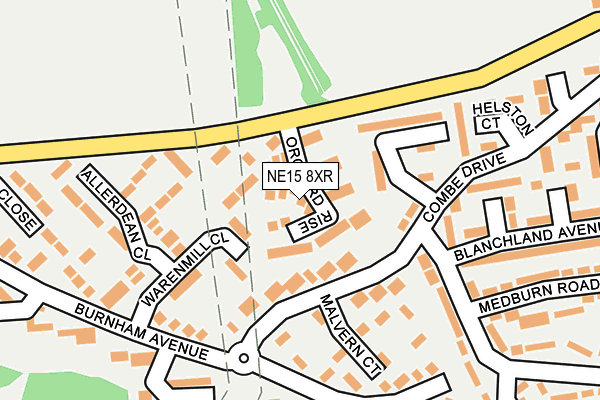
NE15 8XR lies on Orchard Rise in Newcastle Upon Tyne. NE15 8XR is located in the Lemington electoral ward, within the metropolitan district of Newcastle upon Tyne and the English Parliamentary constituency of Newcastle upon Tyne North. The Sub Integrated Care Board (ICB) Location is NHS North East and North Cumbria ICB - 13T and the police force is Northumbria. This postcode has been in use since June 2001.


GetTheData
Source: OS OpenMap – Local (Ordnance Survey)
Source: OS VectorMap District (Ordnance Survey)
Licence: Open Government Licence (requires attribution)
| Easting | 417775 |
| Northing | 565414 |
| Latitude | 54.983013 |
| Longitude | -1.723786 |
GetTheData
Source: Open Postcode Geo
Licence: Open Government Licence
| Street | Orchard Rise |
| Town/City | Newcastle Upon Tyne |
| Country | England |
| Postcode District | NE15 |
➜ See where NE15 is on a map ➜ Where is Newcastle upon Tyne? | |
GetTheData
Source: Land Registry Price Paid Data
Licence: Open Government Licence
Elevation or altitude of NE15 8XR as distance above sea level:
| Metres | Feet | |
|---|---|---|
| Elevation | 70m | 230ft |
Elevation is measured from the approximate centre of the postcode, to the nearest point on an OS contour line from OS Terrain 50, which has contour spacing of ten vertical metres.
➜ How high above sea level am I? Find the elevation of your current position using your device's GPS.
GetTheData
Source: Open Postcode Elevation
Licence: Open Government Licence
| Ward | Lemington |
| Constituency | Newcastle Upon Tyne North |
GetTheData
Source: ONS Postcode Database
Licence: Open Government Licence
| West Denton Park (Burnham Avenue) | Lemington | 181m |
| Combe Drive-hamsterley Crescent (Combe Drive) | Lemington | 191m |
| Combe Drive-tewksbury Road (Combe Drive) | Lemington | 310m |
| Combe Drive-tewksbury Road (Combe Drive) | Lemington | 345m |
| Lemington Road-keats Road (Lemington Road) | Lemington | 489m |
| Blaydon Station | 2km |
| Metrocentre Station | 4.6km |
GetTheData
Source: NaPTAN
Licence: Open Government Licence
| Percentage of properties with Next Generation Access | 100.0% |
| Percentage of properties with Superfast Broadband | 100.0% |
| Percentage of properties with Ultrafast Broadband | 0.0% |
| Percentage of properties with Full Fibre Broadband | 0.0% |
Superfast Broadband is between 30Mbps and 300Mbps
Ultrafast Broadband is > 300Mbps
| Median download speed | 40.0Mbps |
| Average download speed | 45.6Mbps |
| Maximum download speed | 77.61Mbps |
| Median upload speed | 10.0Mbps |
| Average upload speed | 11.7Mbps |
| Maximum upload speed | 20.00Mbps |
| Percentage of properties unable to receive 2Mbps | 0.0% |
| Percentage of properties unable to receive 5Mbps | 0.0% |
| Percentage of properties unable to receive 10Mbps | 0.0% |
| Percentage of properties unable to receive 30Mbps | 0.0% |
GetTheData
Source: Ofcom
Licence: Ofcom Terms of Use (requires attribution)
Estimated total energy consumption in NE15 8XR by fuel type, 2015.
| Consumption (kWh) | 509,531 |
|---|---|
| Meter count | 34 |
| Mean (kWh/meter) | 14,986 |
| Median (kWh/meter) | 15,234 |
| Consumption (kWh) | 124,981 |
|---|---|
| Meter count | 34 |
| Mean (kWh/meter) | 3,676 |
| Median (kWh/meter) | 3,693 |
GetTheData
Source: Postcode level gas estimates: 2015 (experimental)
Source: Postcode level electricity estimates: 2015 (experimental)
Licence: Open Government Licence
GetTheData
Source: ONS Postcode Database
Licence: Open Government Licence

➜ Get more ratings from the Food Standards Agency
GetTheData
Source: Food Standards Agency
Licence: FSA terms & conditions
| Last Collection | |||
|---|---|---|---|
| Location | Mon-Fri | Sat | Distance |
| Moorcroft Road | 17:30 | 11:30 | 522m |
| Chapel House Drive | 17:30 | 11:00 | 1,117m |
| Chapel House Post Office | 17:45 | 12:15 | 1,413m |
GetTheData
Source: Dracos
Licence: Creative Commons Attribution-ShareAlike
The below table lists the International Territorial Level (ITL) codes (formerly Nomenclature of Territorial Units for Statistics (NUTS) codes) and Local Administrative Units (LAU) codes for NE15 8XR:
| ITL 1 Code | Name |
|---|---|
| TLC | North East (England) |
| ITL 2 Code | Name |
| TLC2 | Northumberland, and Tyne and Wear |
| ITL 3 Code | Name |
| TLC22 | Tyneside |
| LAU 1 Code | Name |
| E08000021 | Newcastle upon Tyne |
GetTheData
Source: ONS Postcode Directory
Licence: Open Government Licence
The below table lists the Census Output Area (OA), Lower Layer Super Output Area (LSOA), and Middle Layer Super Output Area (MSOA) for NE15 8XR:
| Code | Name | |
|---|---|---|
| OA | E00042522 | |
| LSOA | E01008381 | Newcastle upon Tyne 021A |
| MSOA | E02001728 | Newcastle upon Tyne 021 |
GetTheData
Source: ONS Postcode Directory
Licence: Open Government Licence
| NE15 8XH | Warenmill Close | 69m |
| NE15 8XD | Combe Drive | 85m |
| NE15 8XB | Combe Drive | 114m |
| NE15 8UG | Combe Drive | 129m |
| NE15 8UQ | Hamsterley Crescent | 132m |
| NE15 8XW | Allerdean Close | 136m |
| NE15 8XE | Malvern Court | 143m |
| NE15 8UB | Valley View | 147m |
| NE15 8UD | Valley View | 152m |
| NE15 8XG | Burnham Avenue | 171m |
GetTheData
Source: Open Postcode Geo; Land Registry Price Paid Data
Licence: Open Government Licence