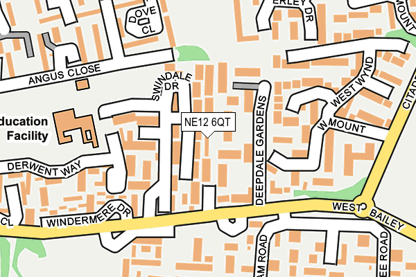
NE12 6QT lies on Martindale Walk in Newcastle Upon Tyne. NE12 6QT is located in the Camperdown electoral ward, within the metropolitan district of North Tyneside and the English Parliamentary constituency of North Tyneside. The Sub Integrated Care Board (ICB) Location is NHS North East and North Cumbria ICB - 99C and the police force is Northumbria. This postcode has been in use since June 1999.


GetTheData
Source: OS OpenMap – Local (Ordnance Survey)
Source: OS VectorMap District (Ordnance Survey)
Licence: Open Government Licence (requires attribution)
| Easting | 427327 |
| Northing | 571346 |
| Latitude | 55.035887 |
| Longitude | -1.573970 |
GetTheData
Source: Open Postcode Geo
Licence: Open Government Licence
| Street | Martindale Walk |
| Town/City | Newcastle Upon Tyne |
| Country | England |
| Postcode District | NE12 |
➜ See where NE12 is on a map ➜ Where is Killingworth? | |
GetTheData
Source: Land Registry Price Paid Data
Licence: Open Government Licence
Elevation or altitude of NE12 6QT as distance above sea level:
| Metres | Feet | |
|---|---|---|
| Elevation | 60m | 197ft |
Elevation is measured from the approximate centre of the postcode, to the nearest point on an OS contour line from OS Terrain 50, which has contour spacing of ten vertical metres.
➜ How high above sea level am I? Find the elevation of your current position using your device's GPS.
GetTheData
Source: Open Postcode Elevation
Licence: Open Government Licence
| Ward | Camperdown |
| Constituency | North Tyneside |
GetTheData
Source: ONS Postcode Database
Licence: Open Government Licence
| West Bailey-garth 4 (West Bailey) | Killingworth | 132m |
| West Bailey-turning Circle (West Bailey) | Killingworth | 136m |
| West Bailey-garth 4 (West Bailey) | Killingworth | 165m |
| Citadel West (Citadel West) | Killingworth | 250m |
| Citadel West - West Mount Estate (Citadel West) | Killingworth | 267m |
GetTheData
Source: NaPTAN
Licence: Open Government Licence
| Percentage of properties with Next Generation Access | 100.0% |
| Percentage of properties with Superfast Broadband | 100.0% |
| Percentage of properties with Ultrafast Broadband | 0.0% |
| Percentage of properties with Full Fibre Broadband | 0.0% |
Superfast Broadband is between 30Mbps and 300Mbps
Ultrafast Broadband is > 300Mbps
| Median download speed | 26.8Mbps |
| Average download speed | 27.4Mbps |
| Maximum download speed | 56.54Mbps |
| Median upload speed | 5.0Mbps |
| Average upload speed | 4.9Mbps |
| Maximum upload speed | 12.82Mbps |
| Percentage of properties unable to receive 2Mbps | 0.0% |
| Percentage of properties unable to receive 5Mbps | 0.0% |
| Percentage of properties unable to receive 10Mbps | 0.0% |
| Percentage of properties unable to receive 30Mbps | 0.0% |
GetTheData
Source: Ofcom
Licence: Ofcom Terms of Use (requires attribution)
Estimated total energy consumption in NE12 6QT by fuel type, 2015.
| Consumption (kWh) | 302,368 |
|---|---|
| Meter count | 27 |
| Mean (kWh/meter) | 11,199 |
| Median (kWh/meter) | 12,969 |
| Consumption (kWh) | 89,572 |
|---|---|
| Meter count | 28 |
| Mean (kWh/meter) | 3,199 |
| Median (kWh/meter) | 2,846 |
GetTheData
Source: Postcode level gas estimates: 2015 (experimental)
Source: Postcode level electricity estimates: 2015 (experimental)
Licence: Open Government Licence
GetTheData
Source: ONS Postcode Database
Licence: Open Government Licence


➜ Get more ratings from the Food Standards Agency
GetTheData
Source: Food Standards Agency
Licence: FSA terms & conditions
| Last Collection | |||
|---|---|---|---|
| Location | Mon-Fri | Sat | Distance |
| Bolam Road | 17:30 | 12:00 | 131m |
| West Bailey | 17:30 | 12:00 | 302m |
| Killingworth Post Office | 17:30 | 12:00 | 478m |
GetTheData
Source: Dracos
Licence: Creative Commons Attribution-ShareAlike
The below table lists the International Territorial Level (ITL) codes (formerly Nomenclature of Territorial Units for Statistics (NUTS) codes) and Local Administrative Units (LAU) codes for NE12 6QT:
| ITL 1 Code | Name |
|---|---|
| TLC | North East (England) |
| ITL 2 Code | Name |
| TLC2 | Northumberland, and Tyne and Wear |
| ITL 3 Code | Name |
| TLC22 | Tyneside |
| LAU 1 Code | Name |
| E08000022 | North Tyneside |
GetTheData
Source: ONS Postcode Directory
Licence: Open Government Licence
The below table lists the Census Output Area (OA), Lower Layer Super Output Area (LSOA), and Middle Layer Super Output Area (MSOA) for NE12 6QT:
| Code | Name | |
|---|---|---|
| OA | E00043027 | |
| LSOA | E01008477 | North Tyneside 008C |
| MSOA | E02001745 | North Tyneside 008 |
GetTheData
Source: ONS Postcode Directory
Licence: Open Government Licence
| NE12 6QS | Deepdale Gardens | 32m |
| NE12 6QU | Swindale Drive | 48m |
| NE12 6TR | Buttermere Close | 104m |
| NE12 6TS | Grasmere Court | 114m |
| NE12 6FR | West Mount | 148m |
| NE12 6TA | Rothbury Close | 174m |
| NE12 6UF | Hallington Mews | 175m |
| NE12 6YE | Wallington Court | 187m |
| NE12 6YH | Bolam Road | 188m |
| NE12 6FP | West Wynd | 189m |
GetTheData
Source: Open Postcode Geo; Land Registry Price Paid Data
Licence: Open Government Licence