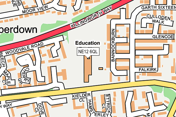
NE12 6QL is located in the Camperdown electoral ward, within the metropolitan district of North Tyneside and the English Parliamentary constituency of North Tyneside. The Sub Integrated Care Board (ICB) Location is NHS North East and North Cumbria ICB - 99C and the police force is Northumbria. This postcode has been in use since June 1999.


GetTheData
Source: OS OpenMap – Local (Ordnance Survey)
Source: OS VectorMap District (Ordnance Survey)
Licence: Open Government Licence (requires attribution)
| Easting | 427440 |
| Northing | 571702 |
| Latitude | 55.039087 |
| Longitude | -1.572182 |
GetTheData
Source: Open Postcode Geo
Licence: Open Government Licence
| Country | England |
| Postcode District | NE12 |
➜ See where NE12 is on a map ➜ Where is Killingworth? | |
GetTheData
Source: Land Registry Price Paid Data
Licence: Open Government Licence
Elevation or altitude of NE12 6QL as distance above sea level:
| Metres | Feet | |
|---|---|---|
| Elevation | 70m | 230ft |
Elevation is measured from the approximate centre of the postcode, to the nearest point on an OS contour line from OS Terrain 50, which has contour spacing of ten vertical metres.
➜ How high above sea level am I? Find the elevation of your current position using your device's GPS.
GetTheData
Source: Open Postcode Elevation
Licence: Open Government Licence
| Ward | Camperdown |
| Constituency | North Tyneside |
GetTheData
Source: ONS Postcode Database
Licence: Open Government Licence
| West Bailey-school (West Bailey) | Killingworth | 88m |
| West Bailey-garth 12 (West Bailey) | Killingworth | 175m |
| West Bailey-garth 15 (West Bailey) | Killingworth | 227m |
| West Bailey-garth 15 (West Bailey) | Killingworth | 236m |
| Greenhills Estate (Greenhills) | Burradon | 301m |
GetTheData
Source: NaPTAN
Licence: Open Government Licence
GetTheData
Source: ONS Postcode Database
Licence: Open Government Licence


➜ Get more ratings from the Food Standards Agency
GetTheData
Source: Food Standards Agency
Licence: FSA terms & conditions
| Last Collection | |||
|---|---|---|---|
| Location | Mon-Fri | Sat | Distance |
| West Bailey | 17:30 | 12:00 | 76m |
| Allanville | 16:00 | 12:00 | 412m |
| Killingworth Post Office | 17:30 | 12:00 | 432m |
GetTheData
Source: Dracos
Licence: Creative Commons Attribution-ShareAlike
The below table lists the International Territorial Level (ITL) codes (formerly Nomenclature of Territorial Units for Statistics (NUTS) codes) and Local Administrative Units (LAU) codes for NE12 6QL:
| ITL 1 Code | Name |
|---|---|
| TLC | North East (England) |
| ITL 2 Code | Name |
| TLC2 | Northumberland, and Tyne and Wear |
| ITL 3 Code | Name |
| TLC22 | Tyneside |
| LAU 1 Code | Name |
| E08000022 | North Tyneside |
GetTheData
Source: ONS Postcode Directory
Licence: Open Government Licence
The below table lists the Census Output Area (OA), Lower Layer Super Output Area (LSOA), and Middle Layer Super Output Area (MSOA) for NE12 6QL:
| Code | Name | |
|---|---|---|
| OA | E00043025 | |
| LSOA | E01008479 | North Tyneside 008D |
| MSOA | E02001745 | North Tyneside 008 |
GetTheData
Source: ONS Postcode Directory
Licence: Open Government Licence
| NE12 6QJ | Bannockburn | 51m |
| NE12 6QH | Agincourt | 83m |
| NE12 6TD | Ettrick Close | 128m |
| NE12 6QG | Blenheim | 141m |
| NE12 6TE | Kielder Close | 153m |
| NE12 6TB | Hamsterley Drive | 173m |
| NE12 6SL | Cypress Gardens | 176m |
| NE12 6QA | Falkirk | 178m |
| NE12 6SD | Willow Gardens | 182m |
| NE12 6TF | Guillemot Row | 194m |
GetTheData
Source: Open Postcode Geo; Land Registry Price Paid Data
Licence: Open Government Licence