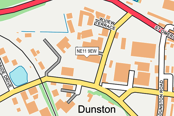
NE11 9EW lies on Parker Court in Dunston, Gateshead. NE11 9EW is located in the Dunston and Teams electoral ward, within the metropolitan district of Gateshead and the English Parliamentary constituency of Gateshead. The Sub Integrated Care Board (ICB) Location is NHS North East and North Cumbria ICB - 13T and the police force is Northumbria. This postcode has been in use since August 1992.


GetTheData
Source: OS OpenMap – Local (Ordnance Survey)
Source: OS VectorMap District (Ordnance Survey)
Licence: Open Government Licence (requires attribution)
| Easting | 422412 |
| Northing | 562555 |
| Latitude | 54.957136 |
| Longitude | -1.651554 |
GetTheData
Source: Open Postcode Geo
Licence: Open Government Licence
| Street | Parker Court |
| Locality | Dunston |
| Town/City | Gateshead |
| Country | England |
| Postcode District | NE11 |
➜ See where NE11 is on a map ➜ Where is Gateshead? | |
GetTheData
Source: Land Registry Price Paid Data
Licence: Open Government Licence
Elevation or altitude of NE11 9EW as distance above sea level:
| Metres | Feet | |
|---|---|---|
| Elevation | 10m | 33ft |
Elevation is measured from the approximate centre of the postcode, to the nearest point on an OS contour line from OS Terrain 50, which has contour spacing of ten vertical metres.
➜ How high above sea level am I? Find the elevation of your current position using your device's GPS.
GetTheData
Source: Open Postcode Elevation
Licence: Open Government Licence
| Ward | Dunston And Teams |
| Constituency | Gateshead |
GetTheData
Source: ONS Postcode Database
Licence: Open Government Licence
1, PARKER COURT, DUNSTON, GATESHEAD, NE11 9EW 2005 28 APR £225,000 |
1, PARKER COURT, DUNSTON, GATESHEAD, NE11 9EW 2003 14 AUG £185,000 |
GetTheData
Source: HM Land Registry Price Paid Data
Licence: Contains HM Land Registry data © Crown copyright and database right 2025. This data is licensed under the Open Government Licence v3.0.
| St Omers Road | Dunston | 81m |
| Wellington Road-st Omers Road (Wellingotn Road) | Dunston | 81m |
| St Omers Road | Dunston | 86m |
| Wellington Road-st Omers Road (Wellington Road) | Dunston | 110m |
| Wellington Road-nelson Street (Wellington Road) | Dunston | 233m |
| Metrocentre Station | 0.9km |
| Dunston Station | 1km |
| Newcastle Station | 2.5km |
GetTheData
Source: NaPTAN
Licence: Open Government Licence
GetTheData
Source: ONS Postcode Database
Licence: Open Government Licence


➜ Get more ratings from the Food Standards Agency
GetTheData
Source: Food Standards Agency
Licence: FSA terms & conditions
| Last Collection | |||
|---|---|---|---|
| Location | Mon-Fri | Sat | Distance |
| Meadow Lane | 18:15 | 11:30 | 422m |
| Dunston Industrial Estate | 18:00 | 11:30 | 449m |
| Wellington Road | 18:00 | 11:30 | 470m |
GetTheData
Source: Dracos
Licence: Creative Commons Attribution-ShareAlike
The below table lists the International Territorial Level (ITL) codes (formerly Nomenclature of Territorial Units for Statistics (NUTS) codes) and Local Administrative Units (LAU) codes for NE11 9EW:
| ITL 1 Code | Name |
|---|---|
| TLC | North East (England) |
| ITL 2 Code | Name |
| TLC2 | Northumberland, and Tyne and Wear |
| ITL 3 Code | Name |
| TLC22 | Tyneside |
| LAU 1 Code | Name |
| E08000037 | Gateshead |
GetTheData
Source: ONS Postcode Directory
Licence: Open Government Licence
The below table lists the Census Output Area (OA), Lower Layer Super Output Area (LSOA), and Middle Layer Super Output Area (MSOA) for NE11 9EW:
| Code | Name | |
|---|---|---|
| OA | E00170012 | |
| LSOA | E01008209 | Gateshead 007A |
| MSOA | E02001688 | Gateshead 007 |
GetTheData
Source: ONS Postcode Directory
Licence: Open Government Licence
| NE11 9EP | Lloyd Court | 57m |
| NE11 9EL | West View Terrace | 112m |
| NE11 9EE | Dunston Road | 248m |
| NE11 9PN | Meadow Lane | 270m |
| NE11 9EF | Whitegate Close | 296m |
| NE11 9EH | Dunston Road | 304m |
| NE11 9PQ | Meadow Close | 323m |
| NE11 9HA | Baker Gardens | 369m |
| NE11 9JT | Halifax Court | 378m |
| NE11 9JW | Halifax Road | 381m |
GetTheData
Source: Open Postcode Geo; Land Registry Price Paid Data
Licence: Open Government Licence