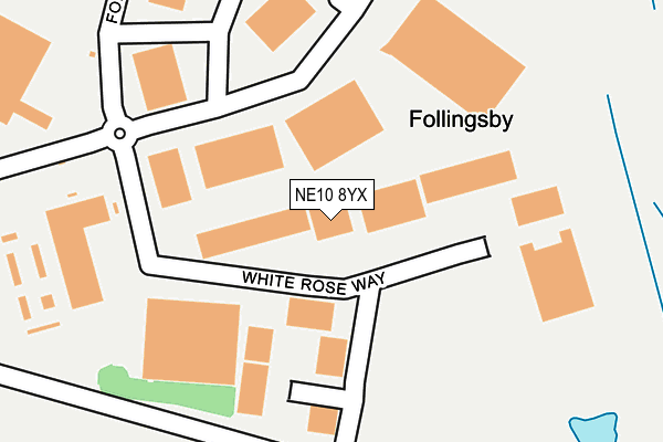
NE10 8YX lies on White Rose Way in Gateshead. NE10 8YX is located in the Wardley and Leam Lane electoral ward, within the metropolitan district of Gateshead and the English Parliamentary constituency of Jarrow. The Sub Integrated Care Board (ICB) Location is NHS North East and North Cumbria ICB - 13T and the police force is Northumbria. This postcode has been in use since December 2001.


GetTheData
Source: OS OpenMap – Local (Ordnance Survey)
Source: OS VectorMap District (Ordnance Survey)
Licence: Open Government Licence (requires attribution)
| Easting | 431021 |
| Northing | 560323 |
| Latitude | 54.936628 |
| Longitude | -1.517377 |
GetTheData
Source: Open Postcode Geo
Licence: Open Government Licence
| Street | White Rose Way |
| Town/City | Gateshead |
| Country | England |
| Postcode District | NE10 |
➜ See where NE10 is on a map ➜ Where is Follingsby? | |
GetTheData
Source: Land Registry Price Paid Data
Licence: Open Government Licence
Elevation or altitude of NE10 8YX as distance above sea level:
| Metres | Feet | |
|---|---|---|
| Elevation | 50m | 164ft |
Elevation is measured from the approximate centre of the postcode, to the nearest point on an OS contour line from OS Terrain 50, which has contour spacing of ten vertical metres.
➜ How high above sea level am I? Find the elevation of your current position using your device's GPS.
GetTheData
Source: Open Postcode Elevation
Licence: Open Government Licence
| Ward | Wardley And Leam Lane |
| Constituency | Jarrow |
GetTheData
Source: ONS Postcode Database
Licence: Open Government Licence
| Follingsby Park (Follingsby Avenue) | Follingsby | 200m |
| Follingsby Park (Follingsby Avenue) | Follingsby | 356m |
| Follingsby Park (Follingsby Way) | Follingsby | 374m |
| Follingsby Park (Follingsby Way) | Follingsby | 513m |
| Follingsby Roundabout (A195) | Follingsby | 746m |
| Heworth Station | 3km |
| Brockley Whins Station | 4.4km |
GetTheData
Source: NaPTAN
Licence: Open Government Licence
GetTheData
Source: ONS Postcode Database
Licence: Open Government Licence


➜ Get more ratings from the Food Standards Agency
GetTheData
Source: Food Standards Agency
Licence: FSA terms & conditions
| Last Collection | |||
|---|---|---|---|
| Location | Mon-Fri | Sat | Distance |
| Follingsby Avenue | 16:15 | 11:30 | 255m |
| Lanchester Close | 16:30 | 10:30 | 1,006m |
| Wardley Lane | 18:15 | 11:30 | 1,238m |
GetTheData
Source: Dracos
Licence: Creative Commons Attribution-ShareAlike
The below table lists the International Territorial Level (ITL) codes (formerly Nomenclature of Territorial Units for Statistics (NUTS) codes) and Local Administrative Units (LAU) codes for NE10 8YX:
| ITL 1 Code | Name |
|---|---|
| TLC | North East (England) |
| ITL 2 Code | Name |
| TLC2 | Northumberland, and Tyne and Wear |
| ITL 3 Code | Name |
| TLC22 | Tyneside |
| LAU 1 Code | Name |
| E08000037 | Gateshead |
GetTheData
Source: ONS Postcode Directory
Licence: Open Government Licence
The below table lists the Census Output Area (OA), Lower Layer Super Output Area (LSOA), and Middle Layer Super Output Area (MSOA) for NE10 8YX:
| Code | Name | |
|---|---|---|
| OA | E00042026 | |
| LSOA | E01008283 | Gateshead 014A |
| MSOA | E02001695 | Gateshead 014 |
GetTheData
Source: ONS Postcode Directory
Licence: Open Government Licence
| NE36 0BZ | Follonsby Terrace | 926m |
| NE10 8UF | Bradbury Close | 943m |
| NE10 8SZ | Sherburn Way | 958m |
| NE10 8TW | Slaley Close | 1004m |
| NE10 8TF | Sherburn Way | 1019m |
| NE10 8SW | Whalton Close | 1024m |
| NE10 8SP | Thropton Close | 1034m |
| NE10 8SQ | Sherburn Way | 1036m |
| NE10 8RG | Sherburn Way | 1042m |
| NE10 8UG | Bowburn Close | 1042m |
GetTheData
Source: Open Postcode Geo; Land Registry Price Paid Data
Licence: Open Government Licence