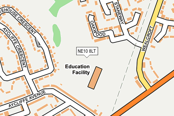
NE10 8LT is located in the Windy Nook and Whitehills electoral ward, within the metropolitan district of Gateshead and the English Parliamentary constituency of Gateshead. The Sub Integrated Care Board (ICB) Location is NHS North East and North Cumbria ICB - 13T and the police force is Northumbria. This postcode has been in use since December 1999.


GetTheData
Source: OS OpenMap – Local (Ordnance Survey)
Source: OS VectorMap District (Ordnance Survey)
Licence: Open Government Licence (requires attribution)
| Easting | 428446 |
| Northing | 559687 |
| Latitude | 54.931065 |
| Longitude | -1.557627 |
GetTheData
Source: Open Postcode Geo
Licence: Open Government Licence
| Country | England |
| Postcode District | NE10 |
➜ See where NE10 is on a map ➜ Where is Gateshead? | |
GetTheData
Source: Land Registry Price Paid Data
Licence: Open Government Licence
Elevation or altitude of NE10 8LT as distance above sea level:
| Metres | Feet | |
|---|---|---|
| Elevation | 130m | 427ft |
Elevation is measured from the approximate centre of the postcode, to the nearest point on an OS contour line from OS Terrain 50, which has contour spacing of ten vertical metres.
➜ How high above sea level am I? Find the elevation of your current position using your device's GPS.
GetTheData
Source: Open Postcode Elevation
Licence: Open Government Licence
| Ward | Windy Nook And Whitehills |
| Constituency | Gateshead |
GetTheData
Source: ONS Postcode Database
Licence: Open Government Licence
| Aycliffe Ave-wallace Gdns (Aycliffe Avenue) | Springwell Estate | 116m |
| Aycliffe Avenue | Springwell Estate | 119m |
| Aycliffe Avenue | Springwell Estate | 174m |
| Wealcroft | Leam Lane | 178m |
| Staneway-wealcroft (Staneway) | Leam Lane | 182m |
| Heworth Station | 2.3km |
| Manors Station | 5.5km |
| Newcastle Station | 5.6km |
GetTheData
Source: NaPTAN
Licence: Open Government Licence
GetTheData
Source: ONS Postcode Database
Licence: Open Government Licence


➜ Get more ratings from the Food Standards Agency
GetTheData
Source: Food Standards Agency
Licence: FSA terms & conditions
| Last Collection | |||
|---|---|---|---|
| Location | Mon-Fri | Sat | Distance |
| Aycliffe Avenue Post Office | 17:15 | 12:00 | 274m |
| Staneway | 17:30 | 10:30 | 481m |
| Leam Lane | 17:30 | 12:15 | 507m |
GetTheData
Source: Dracos
Licence: Creative Commons Attribution-ShareAlike
The below table lists the International Territorial Level (ITL) codes (formerly Nomenclature of Territorial Units for Statistics (NUTS) codes) and Local Administrative Units (LAU) codes for NE10 8LT:
| ITL 1 Code | Name |
|---|---|
| TLC | North East (England) |
| ITL 2 Code | Name |
| TLC2 | Northumberland, and Tyne and Wear |
| ITL 3 Code | Name |
| TLC22 | Tyneside |
| LAU 1 Code | Name |
| E08000037 | Gateshead |
GetTheData
Source: ONS Postcode Directory
Licence: Open Government Licence
The below table lists the Census Output Area (OA), Lower Layer Super Output Area (LSOA), and Middle Layer Super Output Area (MSOA) for NE10 8LT:
| Code | Name | |
|---|---|---|
| OA | E00041743 | |
| LSOA | E01008227 | Gateshead 021E |
| MSOA | E02001702 | Gateshead 021 |
GetTheData
Source: ONS Postcode Directory
Licence: Open Government Licence
| NE9 7BU | Aycliffe Avenue | 103m |
| NE10 8LQ | Hawksfeld | 210m |
| NE9 7BS | Wallace Gardens | 215m |
| NE9 7DJ | Whitehouse Crescent | 233m |
| NE10 8QQ | Wealcroft | 236m |
| NE10 8LU | Oakwood | 262m |
| NE9 7BT | Wallace Gardens | 269m |
| NE9 7AN | Lanchester Avenue | 286m |
| NE10 8LP | Pontdyke | 286m |
| NE9 7DH | Aycliffe Crescent | 293m |
GetTheData
Source: Open Postcode Geo; Land Registry Price Paid Data
Licence: Open Government Licence