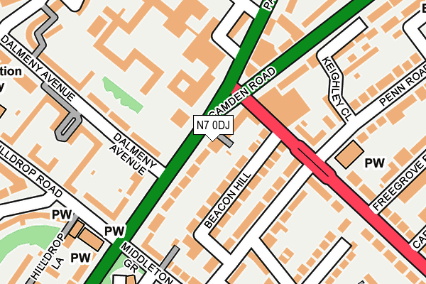
N7 0DJ is located in the Holloway electoral ward, within the London borough of Islington and the English Parliamentary constituency of Islington South and Finsbury. The Sub Integrated Care Board (ICB) Location is NHS North Central London ICB - 93C and the police force is Metropolitan Police. This postcode has been in use since September 2009.


GetTheData
Source: OS OpenMap – Local (Ordnance Survey)
Source: OS VectorMap District (Ordnance Survey)
Licence: Open Government Licence (requires attribution)
| Easting | 530156 |
| Northing | 185424 |
| Latitude | 51.552698 |
| Longitude | -0.124105 |
GetTheData
Source: Open Postcode Geo
Licence: Open Government Licence
| Country | England |
| Postcode District | N7 |
➜ See where N7 is on a map ➜ Where is London? | |
GetTheData
Source: Land Registry Price Paid Data
Licence: Open Government Licence
Elevation or altitude of N7 0DJ as distance above sea level:
| Metres | Feet | |
|---|---|---|
| Elevation | 40m | 131ft |
Elevation is measured from the approximate centre of the postcode, to the nearest point on an OS contour line from OS Terrain 50, which has contour spacing of ten vertical metres.
➜ How high above sea level am I? Find the elevation of your current position using your device's GPS.
GetTheData
Source: Open Postcode Elevation
Licence: Open Government Licence
| Ward | Holloway |
| Constituency | Islington South And Finsbury |
GetTheData
Source: ONS Postcode Database
Licence: Open Government Licence
| H M Prison Holloway (Camden Road) | Lower Holloway | 65m |
| Camden Road H M Prison Holloway (Hillmarton Road) | Lower Holloway | 74m |
| Hillmarton Road H M Prison Holloway | Lower Holloway | 151m |
| Hilldrop Road | Lower Holloway | 250m |
| Hilldrop Road (Camden Road) | Lower Holloway | 258m |
| Caledonian Road Underground Station | Caledonian Road | 606m |
| Holloway Road Underground Station | Holloway Road | 753m |
| Tufnell Park Underground Station | Tufnell Park | 1,094m |
| Kentish Town Underground Station | Kentish Town | 1,183m |
| Arsenal Underground Station | Arsenal | 1,331m |
| Kentish Town Station | 1.2km |
| Caledonian Road & Barnsbury Station | 1.2km |
| Upper Holloway Station | 1.3km |
GetTheData
Source: NaPTAN
Licence: Open Government Licence
GetTheData
Source: ONS Postcode Database
Licence: Open Government Licence

➜ Get more ratings from the Food Standards Agency
GetTheData
Source: Food Standards Agency
Licence: FSA terms & conditions
| Last Collection | |||
|---|---|---|---|
| Location | Mon-Fri | Sat | Distance |
| 30 Hungerford Road | 17:30 | 12:00 | 160m |
| Middleton Grove | 17:30 | 12:00 | 200m |
| Cardwell Road/Crayford Road | 17:30 | 12:00 | 337m |
GetTheData
Source: Dracos
Licence: Creative Commons Attribution-ShareAlike
The below table lists the International Territorial Level (ITL) codes (formerly Nomenclature of Territorial Units for Statistics (NUTS) codes) and Local Administrative Units (LAU) codes for N7 0DJ:
| ITL 1 Code | Name |
|---|---|
| TLI | London |
| ITL 2 Code | Name |
| TLI4 | Inner London - East |
| ITL 3 Code | Name |
| TLI43 | Haringey and Islington |
| LAU 1 Code | Name |
| E09000019 | Islington |
GetTheData
Source: ONS Postcode Directory
Licence: Open Government Licence
The below table lists the Census Output Area (OA), Lower Layer Super Output Area (LSOA), and Middle Layer Super Output Area (MSOA) for N7 0DJ:
| Code | Name | |
|---|---|---|
| OA | E00013774 | |
| LSOA | E01002764 | Islington 010A |
| MSOA | E02000563 | Islington 010 |
GetTheData
Source: ONS Postcode Directory
Licence: Open Government Licence
| N7 0LF | Camden Road | 26m |
| N7 9LY | Beacon Hill | 52m |
| N7 0LG | Camden Road | 65m |
| N7 0JN | Camden Road | 69m |
| N7 0JP | Dalmeny Avenue | 108m |
| N7 9LX | Hungerford Road | 113m |
| N7 0SJ | Camden Road | 121m |
| N7 9LA | Hungerford Road | 149m |
| N7 9JP | Hillmarton Road | 149m |
| N7 0LE | Camden Road | 160m |
GetTheData
Source: Open Postcode Geo; Land Registry Price Paid Data
Licence: Open Government Licence