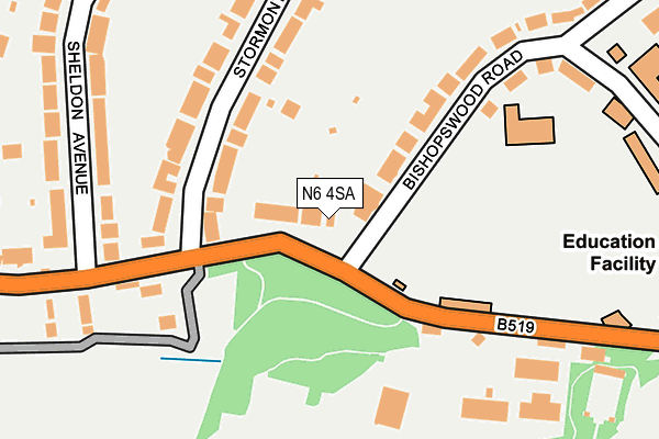
N6 4SA is located in the Highgate electoral ward, within the London borough of Haringey and the English Parliamentary constituency of Hornsey and Wood Green. The Sub Integrated Care Board (ICB) Location is NHS North Central London ICB - 93C and the police force is Metropolitan Police. This postcode has been in use since January 1980.


GetTheData
Source: OS OpenMap – Local (Ordnance Survey)
Source: OS VectorMap District (Ordnance Survey)
Licence: Open Government Licence (requires attribution)
| Easting | 527625 |
| Northing | 187623 |
| Latitude | 51.573038 |
| Longitude | -0.159793 |
GetTheData
Source: Open Postcode Geo
Licence: Open Government Licence
| Country | England |
| Postcode District | N6 |
➜ See where N6 is on a map ➜ Where is London? | |
GetTheData
Source: Land Registry Price Paid Data
Licence: Open Government Licence
Elevation or altitude of N6 4SA as distance above sea level:
| Metres | Feet | |
|---|---|---|
| Elevation | 110m | 361ft |
Elevation is measured from the approximate centre of the postcode, to the nearest point on an OS contour line from OS Terrain 50, which has contour spacing of ten vertical metres.
➜ How high above sea level am I? Find the elevation of your current position using your device's GPS.
GetTheData
Source: Open Postcode Elevation
Licence: Open Government Licence
| Ward | Highgate |
| Constituency | Hornsey And Wood Green |
GetTheData
Source: ONS Postcode Database
Licence: Open Government Licence
| Stormont Road | Highgate | 90m |
| Stormont Road | Highgate | 192m |
| Athlone House | Highgate | 210m |
| Athlone House (Hampstead Lane) | Highgate | 217m |
| Compton Avenue Kenwood House | Highgate | 375m |
| Highgate Underground Station | Highgate | 1,088m |
| Hampstead Heath Station | 2km |
| Gospel Oak Station | 2.1km |
| Upper Holloway Station | 2.3km |
GetTheData
Source: NaPTAN
Licence: Open Government Licence
GetTheData
Source: ONS Postcode Database
Licence: Open Government Licence


➜ Get more ratings from the Food Standards Agency
GetTheData
Source: Food Standards Agency
Licence: FSA terms & conditions
| Last Collection | |||
|---|---|---|---|
| Location | Mon-Fri | Sat | Distance |
| 3 Stormont Road | 17:30 | 12:00 | 119m |
| Bishopswood Road | 17:30 | 12:00 | 279m |
| Sheldon Avenue | 17:30 | 12:00 | 313m |
GetTheData
Source: Dracos
Licence: Creative Commons Attribution-ShareAlike
The below table lists the International Territorial Level (ITL) codes (formerly Nomenclature of Territorial Units for Statistics (NUTS) codes) and Local Administrative Units (LAU) codes for N6 4SA:
| ITL 1 Code | Name |
|---|---|
| TLI | London |
| ITL 2 Code | Name |
| TLI4 | Inner London - East |
| ITL 3 Code | Name |
| TLI43 | Haringey and Islington |
| LAU 1 Code | Name |
| E09000014 | Haringey |
GetTheData
Source: ONS Postcode Directory
Licence: Open Government Licence
The below table lists the Census Output Area (OA), Lower Layer Super Output Area (LSOA), and Middle Layer Super Output Area (MSOA) for N6 4SA:
| Code | Name | |
|---|---|---|
| OA | E00010064 | |
| LSOA | E01002008 | Haringey 030B |
| MSOA | E02000426 | Haringey 030 |
GetTheData
Source: ONS Postcode Directory
Licence: Open Government Licence
| N6 4NX | Hampstead Lane | 39m |
| N6 4NS | Stormont Road | 120m |
| N6 4NL | Stormont Road | 166m |
| N6 4NY | 182m | |
| N6 4JT | Sheldon Avenue | 256m |
| N6 4RU | Hampstead Lane | 256m |
| N6 4LA | Hampstead Lane | 285m |
| N6 4NR | Stormont Road | 290m |
| N6 4JS | Sheldon Avenue | 309m |
| N6 4NP | Stormont Road | 314m |
GetTheData
Source: Open Postcode Geo; Land Registry Price Paid Data
Licence: Open Government Licence