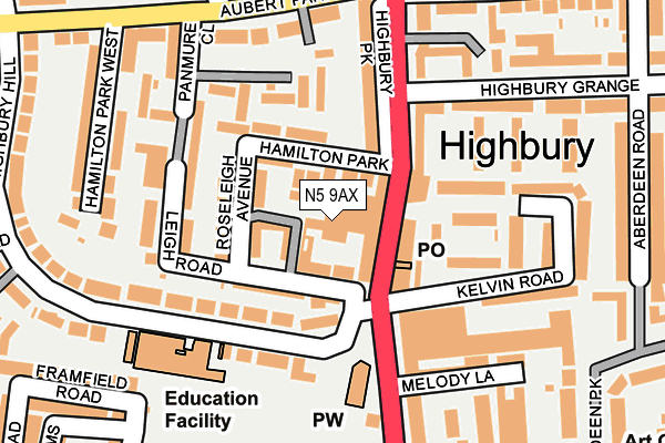
N5 9AX is located in the Highbury electoral ward, within the London borough of Islington and the English Parliamentary constituency of Islington North. The Sub Integrated Care Board (ICB) Location is NHS North Central London ICB - 93C and the police force is Metropolitan Police. This postcode has been in use since August 2009.


GetTheData
Source: OS OpenMap – Local (Ordnance Survey)
Source: OS VectorMap District (Ordnance Survey)
Licence: Open Government Licence (requires attribution)
| Easting | 531892 |
| Northing | 185595 |
| Latitude | 51.553832 |
| Longitude | -0.099017 |
GetTheData
Source: Open Postcode Geo
Licence: Open Government Licence
| Country | England |
| Postcode District | N5 |
➜ See where N5 is on a map ➜ Where is London? | |
GetTheData
Source: Land Registry Price Paid Data
Licence: Open Government Licence
Elevation or altitude of N5 9AX as distance above sea level:
| Metres | Feet | |
|---|---|---|
| Elevation | 40m | 131ft |
Elevation is measured from the approximate centre of the postcode, to the nearest point on an OS contour line from OS Terrain 50, which has contour spacing of ten vertical metres.
➜ How high above sea level am I? Find the elevation of your current position using your device's GPS.
GetTheData
Source: Open Postcode Elevation
Licence: Open Government Licence
| Ward | Highbury |
| Constituency | Islington North |
GetTheData
Source: ONS Postcode Database
Licence: Open Government Licence
| Highbury Barn (Highbury Park) | Highbury | 66m |
| Highbury Barn | Highbury | 101m |
| Highbury Barn (Highbury Grove) | Highbury | 119m |
| Highbury Grange | Highbury | 150m |
| Joan Of Arc School (Highbury Park) | Highbury | 297m |
| Arsenal Underground Station | Arsenal | 794m |
| Highbury & Islington Underground Station | Highbury & Islington | 884m |
| Holloway Road Underground Station | Holloway Road | 995m |
| Finsbury Park Underground Station | Finsbury Park | 1,270m |
| Caledonian Road Underground Station | Caledonian Road | 1,474m |
| Drayton Park Station | 0.5km |
| Canonbury Station | 0.7km |
| Highbury & Islington Station | 0.9km |
GetTheData
Source: NaPTAN
Licence: Open Government Licence
GetTheData
Source: ONS Postcode Database
Licence: Open Government Licence


➜ Get more ratings from the Food Standards Agency
GetTheData
Source: Food Standards Agency
Licence: FSA terms & conditions
| Last Collection | |||
|---|---|---|---|
| Location | Mon-Fri | Sat | Distance |
| 12 Highbury Park | 17:30 | 12:00 | 68m |
| Panmore Close | 17:30 | 12:00 | 174m |
| 74 Aubert Park | 17:30 | 12:00 | 193m |
GetTheData
Source: Dracos
Licence: Creative Commons Attribution-ShareAlike
The below table lists the International Territorial Level (ITL) codes (formerly Nomenclature of Territorial Units for Statistics (NUTS) codes) and Local Administrative Units (LAU) codes for N5 9AX:
| ITL 1 Code | Name |
|---|---|
| TLI | London |
| ITL 2 Code | Name |
| TLI4 | Inner London - East |
| ITL 3 Code | Name |
| TLI43 | Haringey and Islington |
| LAU 1 Code | Name |
| E09000019 | Islington |
GetTheData
Source: ONS Postcode Directory
Licence: Open Government Licence
The below table lists the Census Output Area (OA), Lower Layer Super Output Area (LSOA), and Middle Layer Super Output Area (MSOA) for N5 9AX:
| Code | Name | |
|---|---|---|
| OA | E00013689 | |
| LSOA | E01002745 | Islington 013C |
| MSOA | E02000566 | Islington 013 |
GetTheData
Source: ONS Postcode Directory
Licence: Open Government Licence
| N5 1SB | De Barowe Mews | 25m |
| N5 1QJ | Highbury Park | 39m |
| N5 1SS | Leigh Road | 43m |
| N5 1SH | Hamilton Park | 46m |
| N5 2AB | Highbury Park | 66m |
| N5 1ST | Leigh Road | 75m |
| N5 2AA | Highbury Park | 77m |
| N5 1SJ | Hamilton Park | 86m |
| N5 1SP | Roseleigh Avenue | 99m |
| N5 1SN | Hamilton Park | 105m |
GetTheData
Source: Open Postcode Geo; Land Registry Price Paid Data
Licence: Open Government Licence