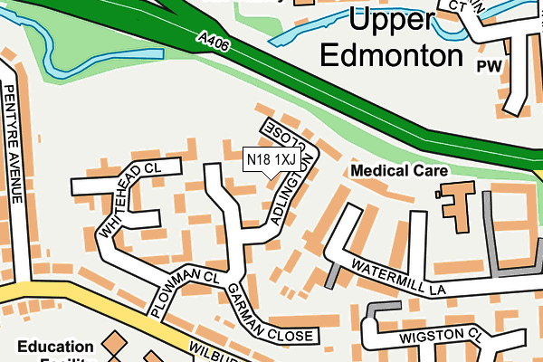
N18 1XJ lies on Adlington Close in London. N18 1XJ is located in the Upper Edmonton electoral ward, within the London borough of Enfield and the English Parliamentary constituency of Edmonton. The Sub Integrated Care Board (ICB) Location is NHS North Central London ICB - 93C and the police force is Metropolitan Police. This postcode has been in use since January 1995.


GetTheData
Source: OS OpenMap – Local (Ordnance Survey)
Source: OS VectorMap District (Ordnance Survey)
Licence: Open Government Licence (requires attribution)
| Easting | 532982 |
| Northing | 192326 |
| Latitude | 51.614063 |
| Longitude | -0.080757 |
GetTheData
Source: Open Postcode Geo
Licence: Open Government Licence
| Street | Adlington Close |
| Town/City | London |
| Country | England |
| Postcode District | N18 |
➜ See where N18 is on a map ➜ Where is Edmonton? | |
GetTheData
Source: Land Registry Price Paid Data
Licence: Open Government Licence
Elevation or altitude of N18 1XJ as distance above sea level:
| Metres | Feet | |
|---|---|---|
| Elevation | 20m | 66ft |
Elevation is measured from the approximate centre of the postcode, to the nearest point on an OS contour line from OS Terrain 50, which has contour spacing of ten vertical metres.
➜ How high above sea level am I? Find the elevation of your current position using your device's GPS.
GetTheData
Source: Open Postcode Elevation
Licence: Open Government Licence
| Ward | Upper Edmonton |
| Constituency | Edmonton |
GetTheData
Source: ONS Postcode Database
Licence: Open Government Licence
| Plowman Close Wilbury Primar (Wilbury Way) | Edmonton | 235m |
| Plowman Close Wilbury Primar (Wilbury Way) | Edmonton | 239m |
| Millfield Theatre (Silver Street) | Edmonton | 287m |
| North Middlesex Hospiotal Lopen Road | Edmonton | 307m |
| Wigston Close (Wilbury Way) | Edmonton | 316m |
| Silver Street Station | 0.9km |
| White Hart Lane Station | 1.2km |
| Edmonton Green Station | 1.8km |
GetTheData
Source: NaPTAN
Licence: Open Government Licence
| Percentage of properties with Next Generation Access | 100.0% |
| Percentage of properties with Superfast Broadband | 100.0% |
| Percentage of properties with Ultrafast Broadband | 100.0% |
| Percentage of properties with Full Fibre Broadband | 0.0% |
Superfast Broadband is between 30Mbps and 300Mbps
Ultrafast Broadband is > 300Mbps
| Median download speed | 78.1Mbps |
| Average download speed | 76.1Mbps |
| Maximum download speed | 200.00Mbps |
| Median upload speed | 19.5Mbps |
| Average upload speed | 13.5Mbps |
| Maximum upload speed | 20.00Mbps |
| Percentage of properties unable to receive 2Mbps | 0.0% |
| Percentage of properties unable to receive 5Mbps | 0.0% |
| Percentage of properties unable to receive 10Mbps | 0.0% |
| Percentage of properties unable to receive 30Mbps | 0.0% |
GetTheData
Source: Ofcom
Licence: Ofcom Terms of Use (requires attribution)
Estimated total energy consumption in N18 1XJ by fuel type, 2015.
| Consumption (kWh) | 191,136 |
|---|---|
| Meter count | 15 |
| Mean (kWh/meter) | 12,742 |
| Median (kWh/meter) | 12,293 |
| Consumption (kWh) | 43,758 |
|---|---|
| Meter count | 12 |
| Mean (kWh/meter) | 3,646 |
| Median (kWh/meter) | 3,433 |
GetTheData
Source: Postcode level gas estimates: 2015 (experimental)
Source: Postcode level electricity estimates: 2015 (experimental)
Licence: Open Government Licence
GetTheData
Source: ONS Postcode Database
Licence: Open Government Licence


➜ Get more ratings from the Food Standards Agency
GetTheData
Source: Food Standards Agency
Licence: FSA terms & conditions
| Last Collection | |||
|---|---|---|---|
| Location | Mon-Fri | Sat | Distance |
| 77 Weir Hall Road | 17:30 | 12:00 | 395m |
| 19 Kendall Parade | 17:30 | 12:00 | 398m |
| Wilbury Way/Pasteur Gardens | 17:30 | 12:00 | 412m |
GetTheData
Source: Dracos
Licence: Creative Commons Attribution-ShareAlike
The below table lists the International Territorial Level (ITL) codes (formerly Nomenclature of Territorial Units for Statistics (NUTS) codes) and Local Administrative Units (LAU) codes for N18 1XJ:
| ITL 1 Code | Name |
|---|---|
| TLI | London |
| ITL 2 Code | Name |
| TLI5 | Outer London - East and North East |
| ITL 3 Code | Name |
| TLI54 | Enfield |
| LAU 1 Code | Name |
| E09000010 | Enfield |
GetTheData
Source: ONS Postcode Directory
Licence: Open Government Licence
The below table lists the Census Output Area (OA), Lower Layer Super Output Area (LSOA), and Middle Layer Super Output Area (MSOA) for N18 1XJ:
| Code | Name | |
|---|---|---|
| OA | E00007723 | |
| LSOA | E01001562 | Enfield 037D |
| MSOA | E02006793 | Enfield 037 |
GetTheData
Source: ONS Postcode Directory
Licence: Open Government Licence
| N18 1XA | Plowman Close | 58m |
| N18 1XB | Plowman Close | 82m |
| N18 1FD | Watermill Lane | 128m |
| N18 1XD | Plowman Close | 131m |
| N18 1UZ | Whitehead Close | 154m |
| N18 1UY | Whitehead Close | 156m |
| N18 1BX | Wilbury Way | 192m |
| N18 1BU | Wilbury Way | 227m |
| N18 1QS | Strand Place | 229m |
| N18 1BZ | Wilbury Way | 247m |
GetTheData
Source: Open Postcode Geo; Land Registry Price Paid Data
Licence: Open Government Licence