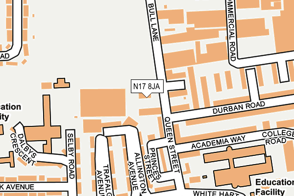
N17 8JA lies on Queen Street in London. N17 8JA is located in the Bruce Castle electoral ward, within the London borough of Haringey and the English Parliamentary constituency of Tottenham. The Sub Integrated Care Board (ICB) Location is NHS North Central London ICB - 93C and the police force is Metropolitan Police. This postcode has been in use since March 1988.


GetTheData
Source: OS OpenMap – Local (Ordnance Survey)
Source: OS VectorMap District (Ordnance Survey)
Licence: Open Government Licence (requires attribution)
| Easting | 533329 |
| Northing | 191655 |
| Latitude | 51.607952 |
| Longitude | -0.076004 |
GetTheData
Source: Open Postcode Geo
Licence: Open Government Licence
| Street | Queen Street |
| Town/City | London |
| Country | England |
| Postcode District | N17 |
➜ See where N17 is on a map | |
GetTheData
Source: Land Registry Price Paid Data
Licence: Open Government Licence
Elevation or altitude of N17 8JA as distance above sea level:
| Metres | Feet | |
|---|---|---|
| Elevation | 20m | 66ft |
Elevation is measured from the approximate centre of the postcode, to the nearest point on an OS contour line from OS Terrain 50, which has contour spacing of ten vertical metres.
➜ How high above sea level am I? Find the elevation of your current position using your device's GPS.
GetTheData
Source: Open Postcode Elevation
Licence: Open Government Licence
| Ward | Bruce Castle |
| Constituency | Tottenham |
GetTheData
Source: ONS Postcode Database
Licence: Open Government Licence
| Trafalgar Avenue White Hart Lane | Tottenham | 234m |
| Selby Road White Hart Lane | Tottenham | 302m |
| Selby Road White Hart Lane | Tottenham | 317m |
| Haringey Sixth Form Centre | Tottenham | 333m |
| Haringey Sixth Form Centre (Creighton Road) | Tottenham | 367m |
| White Hart Lane Station | 0.5km |
| Silver Street Station | 1km |
| Bruce Grove Station | 1.6km |
GetTheData
Source: NaPTAN
Licence: Open Government Licence
GetTheData
Source: ONS Postcode Database
Licence: Open Government Licence

➜ Get more ratings from the Food Standards Agency
GetTheData
Source: Food Standards Agency
Licence: FSA terms & conditions
| Last Collection | |||
|---|---|---|---|
| Location | Mon-Fri | Sat | Distance |
| Queen Street | 17:30 | 12:00 | 95m |
| White Hart Lane/Trafalger Ave | 17:30 | 12:00 | 229m |
| Commercial Road/Bridport Road | 17:30 | 12:00 | 458m |
GetTheData
Source: Dracos
Licence: Creative Commons Attribution-ShareAlike
The below table lists the International Territorial Level (ITL) codes (formerly Nomenclature of Territorial Units for Statistics (NUTS) codes) and Local Administrative Units (LAU) codes for N17 8JA:
| ITL 1 Code | Name |
|---|---|
| TLI | London |
| ITL 2 Code | Name |
| TLI4 | Inner London - East |
| ITL 3 Code | Name |
| TLI43 | Haringey and Islington |
| LAU 1 Code | Name |
| E09000014 | Haringey |
GetTheData
Source: ONS Postcode Directory
Licence: Open Government Licence
The below table lists the Census Output Area (OA), Lower Layer Super Output Area (LSOA), and Middle Layer Super Output Area (MSOA) for N17 8JA:
| Code | Name | |
|---|---|---|
| OA | E00010495 | |
| LSOA | E01002092 | Haringey 006B |
| MSOA | E02000402 | Haringey 006 |
GetTheData
Source: ONS Postcode Directory
Licence: Open Government Licence
| N17 8HU | Queen Street | 59m |
| N17 8JB | Princes Street | 79m |
| N17 8HY | Queen Street | 84m |
| N17 8HX | Queen Street | 105m |
| N17 8JE | Allington Avenue | 118m |
| N18 1RA | Bull Lane | 126m |
| N17 8HE | Academia Way | 150m |
| N17 8HQ | Academia Way | 150m |
| N18 1SX | Bull Lane | 167m |
| N17 8JG | Trafalgar Avenue | 168m |
GetTheData
Source: Open Postcode Geo; Land Registry Price Paid Data
Licence: Open Government Licence