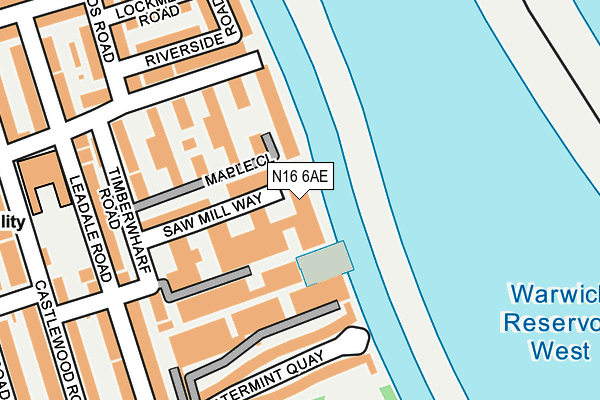
N16 6AE lies on Saw Mill Way in London. N16 6AE is located in the Springfield electoral ward, within the London borough of Hackney and the English Parliamentary constituency of Hackney North and Stoke Newington. The Sub Integrated Care Board (ICB) Location is NHS North East London ICB - A3A8R and the police force is Metropolitan Police. This postcode has been in use since May 2009.


GetTheData
Source: OS OpenMap – Local (Ordnance Survey)
Source: OS VectorMap District (Ordnance Survey)
Licence: Open Government Licence (requires attribution)
| Easting | 534453 |
| Northing | 188182 |
| Latitude | 51.576476 |
| Longitude | -0.061111 |
GetTheData
Source: Open Postcode Geo
Licence: Open Government Licence
| Street | Saw Mill Way |
| Town/City | London |
| Country | England |
| Postcode District | N16 |
➜ See where N16 is on a map ➜ Where is London? | |
GetTheData
Source: Land Registry Price Paid Data
Licence: Open Government Licence
Elevation or altitude of N16 6AE as distance above sea level:
| Metres | Feet | |
|---|---|---|
| Elevation | 10m | 33ft |
Elevation is measured from the approximate centre of the postcode, to the nearest point on an OS contour line from OS Terrain 50, which has contour spacing of ten vertical metres.
➜ How high above sea level am I? Find the elevation of your current position using your device's GPS.
GetTheData
Source: Open Postcode Elevation
Licence: Open Government Licence
| Ward | Springfield |
| Constituency | Hackney North And Stoke Newington |
GetTheData
Source: ONS Postcode Database
Licence: Open Government Licence
| Grovelands Road South Tottenham | South Tottenham | 215m |
| Egerton Road (N15) | South Tottenham | 242m |
| Rookwood Road | Stamford Hill | 521m |
| Rookwood Road | Stamford Hill | 553m |
| Clapton Common | Stamford Hill | 654m |
| Seven Sisters Underground Station | Seven Sisters | 1,102m |
| Tottenham Hale Underground Station | Tottenham Hale | 1,295m |
| Blackhorse Road Underground Station | Blackhorse Road | 1,806m |
| South Tottenham Station | 0.9km |
| Stamford Hill Station | 1.1km |
| Seven Sisters Station | 1.2km |
GetTheData
Source: NaPTAN
Licence: Open Government Licence
| Percentage of properties with Next Generation Access | 100.0% |
| Percentage of properties with Superfast Broadband | 100.0% |
| Percentage of properties with Ultrafast Broadband | 0.0% |
| Percentage of properties with Full Fibre Broadband | 0.0% |
Superfast Broadband is between 30Mbps and 300Mbps
Ultrafast Broadband is > 300Mbps
| Median download speed | 32.4Mbps |
| Average download speed | 29.2Mbps |
| Maximum download speed | 50.14Mbps |
| Median upload speed | 9.3Mbps |
| Average upload speed | 7.3Mbps |
| Maximum upload speed | 11.26Mbps |
| Percentage of properties unable to receive 2Mbps | 0.0% |
| Percentage of properties unable to receive 5Mbps | 0.0% |
| Percentage of properties unable to receive 10Mbps | 0.0% |
| Percentage of properties unable to receive 30Mbps | 0.0% |
GetTheData
Source: Ofcom
Licence: Ofcom Terms of Use (requires attribution)
Estimated total energy consumption in N16 6AE by fuel type, 2015.
| Consumption (kWh) | 111,975 |
|---|---|
| Meter count | 27 |
| Mean (kWh/meter) | 4,147 |
| Median (kWh/meter) | 4,255 |
| Consumption (kWh) | 55,819 |
|---|---|
| Meter count | 27 |
| Mean (kWh/meter) | 2,067 |
| Median (kWh/meter) | 1,511 |
GetTheData
Source: Postcode level gas estimates: 2015 (experimental)
Source: Postcode level electricity estimates: 2015 (experimental)
Licence: Open Government Licence
GetTheData
Source: ONS Postcode Database
Licence: Open Government Licence

➜ Get more ratings from the Food Standards Agency
GetTheData
Source: Food Standards Agency
Licence: FSA terms & conditions
| Last Collection | |||
|---|---|---|---|
| Location | Mon-Fri | Sat | Distance |
| Craven Park Road/Castlewood Road | 17:30 | 12:00 | 287m |
| Castlewood Road/Mountfield Road | 17:30 | 12:00 | 382m |
| Ravensdale Road/Rookwood Road | 17:30 | 12:00 | 496m |
GetTheData
Source: Dracos
Licence: Creative Commons Attribution-ShareAlike
The below table lists the International Territorial Level (ITL) codes (formerly Nomenclature of Territorial Units for Statistics (NUTS) codes) and Local Administrative Units (LAU) codes for N16 6AE:
| ITL 1 Code | Name |
|---|---|
| TLI | London |
| ITL 2 Code | Name |
| TLI4 | Inner London - East |
| ITL 3 Code | Name |
| TLI41 | Hackney and Newham |
| LAU 1 Code | Name |
| E09000012 | Hackney |
GetTheData
Source: ONS Postcode Directory
Licence: Open Government Licence
The below table lists the Census Output Area (OA), Lower Layer Super Output Area (LSOA), and Middle Layer Super Output Area (MSOA) for N16 6AE:
| Code | Name | |
|---|---|---|
| OA | E00009088 | |
| LSOA | E01001823 | Hackney 001D |
| MSOA | E02000345 | Hackney 001 |
GetTheData
Source: ONS Postcode Directory
Licence: Open Government Licence
| N16 6DF | Maple Close | 83m |
| N16 6DB | Timberwharf Road | 97m |
| N15 6AN | Craven Park Road | 114m |
| N15 6AG | Craven Park Road | 128m |
| N16 6DN | Watermint Quay | 138m |
| N15 6AE | Craven Park Road | 153m |
| N16 6DD | Watermint Quay | 187m |
| N15 6DA | Riverside Road | 198m |
| N16 6DG | Leadale Road | 199m |
| N15 6BS | Grovelands Road | 203m |
GetTheData
Source: Open Postcode Geo; Land Registry Price Paid Data
Licence: Open Government Licence