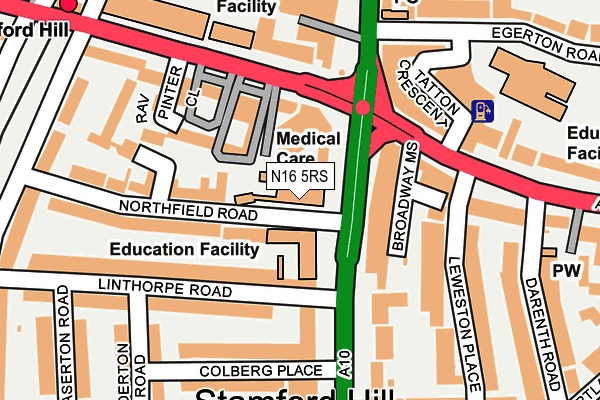
N16 5RS is located in the Springfield electoral ward, within the London borough of Hackney and the English Parliamentary constituency of Hackney North and Stoke Newington. The Sub Integrated Care Board (ICB) Location is NHS North East London ICB - A3A8R and the police force is Metropolitan Police. This postcode has been in use since January 1980.


GetTheData
Source: OS OpenMap – Local (Ordnance Survey)
Source: OS VectorMap District (Ordnance Survey)
Licence: Open Government Licence (requires attribution)
| Easting | 533613 |
| Northing | 187732 |
| Latitude | 51.572631 |
| Longitude | -0.073397 |
GetTheData
Source: Open Postcode Geo
Licence: Open Government Licence
| Country | England |
| Postcode District | N16 |
➜ See where N16 is on a map ➜ Where is London? | |
GetTheData
Source: Land Registry Price Paid Data
Licence: Open Government Licence
Elevation or altitude of N16 5RS as distance above sea level:
| Metres | Feet | |
|---|---|---|
| Elevation | 30m | 98ft |
Elevation is measured from the approximate centre of the postcode, to the nearest point on an OS contour line from OS Terrain 50, which has contour spacing of ten vertical metres.
➜ How high above sea level am I? Find the elevation of your current position using your device's GPS.
GetTheData
Source: Open Postcode Elevation
Licence: Open Government Licence
| Ward | Springfield |
| Constituency | Hackney North And Stoke Newington |
GetTheData
Source: ONS Postcode Database
Licence: Open Government Licence
| Stamford Hill Broadway | Stamford Hill | 42m |
| Stamford Hill Broadway (Stamford Hill) | Stamford Hill | 50m |
| Stamford Hill Broadway | Stamford Hill | 63m |
| Stamford Hill Broadway | Stamford Hill | 70m |
| Stamford Hill Station | Stamford Hill | 121m |
| Seven Sisters Underground Station | Seven Sisters | 1,191m |
| Stamford Hill Station | 0.3km |
| Stoke Newington Station | 0.8km |
| South Tottenham Station | 0.9km |
GetTheData
Source: NaPTAN
Licence: Open Government Licence
GetTheData
Source: ONS Postcode Database
Licence: Open Government Licence


➜ Get more ratings from the Food Standards Agency
GetTheData
Source: Food Standards Agency
Licence: FSA terms & conditions
| Last Collection | |||
|---|---|---|---|
| Location | Mon-Fri | Sat | Distance |
| 149 Clapton Common | 17:00 | 11:30 | 146m |
| Linthorpe Road/Wilderton Road | 17:30 | 12:00 | 178m |
| 250-252 Stamford Hill | 17:30 | 12:00 | 198m |
GetTheData
Source: Dracos
Licence: Creative Commons Attribution-ShareAlike
The below table lists the International Territorial Level (ITL) codes (formerly Nomenclature of Territorial Units for Statistics (NUTS) codes) and Local Administrative Units (LAU) codes for N16 5RS:
| ITL 1 Code | Name |
|---|---|
| TLI | London |
| ITL 2 Code | Name |
| TLI4 | Inner London - East |
| ITL 3 Code | Name |
| TLI41 | Hackney and Newham |
| LAU 1 Code | Name |
| E09000012 | Hackney |
GetTheData
Source: ONS Postcode Directory
Licence: Open Government Licence
The below table lists the Census Output Area (OA), Lower Layer Super Output Area (LSOA), and Middle Layer Super Output Area (MSOA) for N16 5RS:
| Code | Name | |
|---|---|---|
| OA | E00009022 | |
| LSOA | E01001809 | Hackney 001B |
| MSOA | E02000345 | Hackney 001 |
GetTheData
Source: ONS Postcode Directory
Licence: Open Government Licence
| N16 5RY | Stamford Hill | 42m |
| N16 6QX | Stamford Hill | 81m |
| N16 5RW | Stamford Hill | 82m |
| N16 5LS | Amhurst Park | 86m |
| N16 5LT | Amhurst Park | 86m |
| N16 6RA | Stamford Hill | 92m |
| N16 5LP | Amhurst Park | 97m |
| N16 5LU | Amhurst Park | 124m |
| N16 5RN | Northfield Road | 131m |
| N16 5RE | Linthorpe Road | 140m |
GetTheData
Source: Open Postcode Geo; Land Registry Price Paid Data
Licence: Open Government Licence