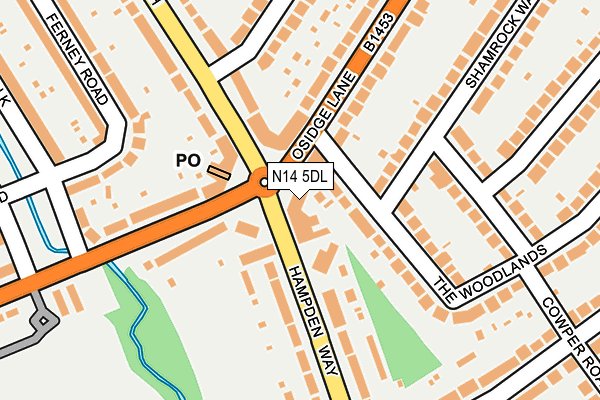
N14 5DL is located in the Brunswick Park electoral ward, within the London borough of Barnet and the English Parliamentary constituency of Chipping Barnet. The Sub Integrated Care Board (ICB) Location is NHS North Central London ICB - 93C and the police force is Metropolitan Police. This postcode has been in use since January 1980.


GetTheData
Source: OS OpenMap – Local (Ordnance Survey)
Source: OS VectorMap District (Ordnance Survey)
Licence: Open Government Licence (requires attribution)
| Easting | 528657 |
| Northing | 194216 |
| Latitude | 51.632055 |
| Longitude | -0.142467 |
GetTheData
Source: Open Postcode Geo
Licence: Open Government Licence
| Country | England |
| Postcode District | N14 |
➜ See where N14 is on a map ➜ Where is London? | |
GetTheData
Source: Land Registry Price Paid Data
Licence: Open Government Licence
Elevation or altitude of N14 5DL as distance above sea level:
| Metres | Feet | |
|---|---|---|
| Elevation | 50m | 164ft |
Elevation is measured from the approximate centre of the postcode, to the nearest point on an OS contour line from OS Terrain 50, which has contour spacing of ten vertical metres.
➜ How high above sea level am I? Find the elevation of your current position using your device's GPS.
GetTheData
Source: Open Postcode Elevation
Licence: Open Government Licence
| Ward | Brunswick Park |
| Constituency | Chipping Barnet |
GetTheData
Source: ONS Postcode Database
Licence: Open Government Licence
| Hampden Way | Osidge | 36m |
| Hampden Square (Brookside South) | Osidge | 64m |
| Hampden Square | Osidge | 65m |
| Hampden Square (Hampden Way) | Osidge | 73m |
| Exeter Road Brookside South | Osidge | 193m |
| Southgate Underground Station | Southgate | 1,016m |
| Oakleigh Park Station | 1.8km |
| New Southgate Station | 2km |
| Palmers Green Station | 2.7km |
GetTheData
Source: NaPTAN
Licence: Open Government Licence
| Percentage of properties with Next Generation Access | 100.0% |
| Percentage of properties with Superfast Broadband | 100.0% |
| Percentage of properties with Ultrafast Broadband | 100.0% |
| Percentage of properties with Full Fibre Broadband | 100.0% |
Superfast Broadband is between 30Mbps and 300Mbps
Ultrafast Broadband is > 300Mbps
| Percentage of properties unable to receive 2Mbps | 0.0% |
| Percentage of properties unable to receive 5Mbps | 0.0% |
| Percentage of properties unable to receive 10Mbps | 0.0% |
| Percentage of properties unable to receive 30Mbps | 0.0% |
GetTheData
Source: Ofcom
Licence: Ofcom Terms of Use (requires attribution)
GetTheData
Source: ONS Postcode Database
Licence: Open Government Licence


➜ Get more ratings from the Food Standards Agency
GetTheData
Source: Food Standards Agency
Licence: FSA terms & conditions
| Last Collection | |||
|---|---|---|---|
| Location | Mon-Fri | Sat | Distance |
| 12 Hampden Square | 17:30 | 12:00 | 69m |
| Oakdale/Manor Drive | 17:30 | 12:00 | 378m |
| Arlington Road/Cowper Road | 17:30 | 12:00 | 403m |
GetTheData
Source: Dracos
Licence: Creative Commons Attribution-ShareAlike
The below table lists the International Territorial Level (ITL) codes (formerly Nomenclature of Territorial Units for Statistics (NUTS) codes) and Local Administrative Units (LAU) codes for N14 5DL:
| ITL 1 Code | Name |
|---|---|
| TLI | London |
| ITL 2 Code | Name |
| TLI7 | Outer London - West and North West |
| ITL 3 Code | Name |
| TLI71 | Barnet |
| LAU 1 Code | Name |
| E09000003 | Barnet |
GetTheData
Source: ONS Postcode Directory
Licence: Open Government Licence
The below table lists the Census Output Area (OA), Lower Layer Super Output Area (LSOA), and Middle Layer Super Output Area (MSOA) for N14 5DL:
| Code | Name | |
|---|---|---|
| OA | E00000616 | |
| LSOA | E01000116 | Barnet 009B |
| MSOA | E02000032 | Barnet 009 |
GetTheData
Source: ONS Postcode Directory
Licence: Open Government Licence
| N14 5JP | Hampden Square | 12m |
| N14 5JN | Onslow Parade | 63m |
| N14 5JR | Hampden Square | 85m |
| N14 5DS | Osidge Lane | 111m |
| N14 5DJ | Hampden Way | 131m |
| N14 5RX | The Woodlands | 137m |
| N14 5RU | The Woodlands | 139m |
| N14 5DN | Osidge Lane | 150m |
| N14 5DT | Osidge Lane | 154m |
| N14 5DX | Hampden Way | 164m |
GetTheData
Source: Open Postcode Geo; Land Registry Price Paid Data
Licence: Open Government Licence