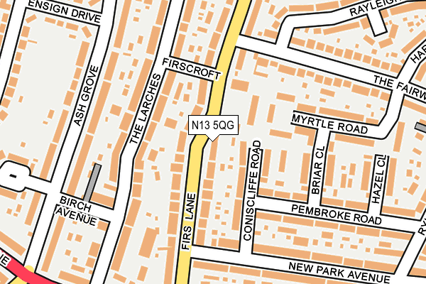
N13 5QG lies on Firs Lane in London. N13 5QG is located in the Highfield electoral ward, within the London borough of Enfield and the English Parliamentary constituency of Enfield, Southgate. The Sub Integrated Care Board (ICB) Location is NHS North Central London ICB - 93C and the police force is Metropolitan Police. This postcode has been in use since January 1980.


GetTheData
Source: OS OpenMap – Local (Ordnance Survey)
Source: OS VectorMap District (Ordnance Survey)
Licence: Open Government Licence (requires attribution)
| Easting | 532296 |
| Northing | 193207 |
| Latitude | 51.622142 |
| Longitude | -0.090327 |
GetTheData
Source: Open Postcode Geo
Licence: Open Government Licence
| Street | Firs Lane |
| Town/City | London |
| Country | England |
| Postcode District | N13 |
➜ See where N13 is on a map ➜ Where is London? | |
GetTheData
Source: Land Registry Price Paid Data
Licence: Open Government Licence
Elevation or altitude of N13 5QG as distance above sea level:
| Metres | Feet | |
|---|---|---|
| Elevation | 20m | 66ft |
Elevation is measured from the approximate centre of the postcode, to the nearest point on an OS contour line from OS Terrain 50, which has contour spacing of ten vertical metres.
➜ How high above sea level am I? Find the elevation of your current position using your device's GPS.
GetTheData
Source: Open Postcode Elevation
Licence: Open Government Licence
| Ward | Highfield |
| Constituency | Enfield, Southgate |
GetTheData
Source: ONS Postcode Database
Licence: Open Government Licence
| Hedge Lane | Palmers Green | 340m |
| Hedge Lane | Palmers Green | 458m |
| Westerham Avenue | Edmonton | 528m |
| Hedge Lane Taplow Road | Palmers Green | 531m |
| The Fairway (N18) | Edmonton | 550m |
| Palmers Green Station | 1.5km |
| Winchmore Hill Station | 1.5km |
| Silver Street Station | 1.8km |
GetTheData
Source: NaPTAN
Licence: Open Government Licence
| Percentage of properties with Next Generation Access | 100.0% |
| Percentage of properties with Superfast Broadband | 100.0% |
| Percentage of properties with Ultrafast Broadband | 100.0% |
| Percentage of properties with Full Fibre Broadband | 0.0% |
Superfast Broadband is between 30Mbps and 300Mbps
Ultrafast Broadband is > 300Mbps
| Percentage of properties unable to receive 2Mbps | 0.0% |
| Percentage of properties unable to receive 5Mbps | 0.0% |
| Percentage of properties unable to receive 10Mbps | 0.0% |
| Percentage of properties unable to receive 30Mbps | 0.0% |
GetTheData
Source: Ofcom
Licence: Ofcom Terms of Use (requires attribution)
GetTheData
Source: ONS Postcode Database
Licence: Open Government Licence


➜ Get more ratings from the Food Standards Agency
GetTheData
Source: Food Standards Agency
Licence: FSA terms & conditions
| Last Collection | |||
|---|---|---|---|
| Location | Mon-Fri | Sat | Distance |
| Harlow Road/The Fairway | 17:30 | 12:00 | 291m |
| Hedge Lane/Ash Grove | 17:30 | 12:00 | 299m |
| Rylston Road | 17:30 | 12:00 | 320m |
GetTheData
Source: Dracos
Licence: Creative Commons Attribution-ShareAlike
The below table lists the International Territorial Level (ITL) codes (formerly Nomenclature of Territorial Units for Statistics (NUTS) codes) and Local Administrative Units (LAU) codes for N13 5QG:
| ITL 1 Code | Name |
|---|---|
| TLI | London |
| ITL 2 Code | Name |
| TLI5 | Outer London - East and North East |
| ITL 3 Code | Name |
| TLI54 | Enfield |
| LAU 1 Code | Name |
| E09000010 | Enfield |
GetTheData
Source: ONS Postcode Directory
Licence: Open Government Licence
The below table lists the Census Output Area (OA), Lower Layer Super Output Area (LSOA), and Middle Layer Super Output Area (MSOA) for N13 5QG:
| Code | Name | |
|---|---|---|
| OA | E00007458 | |
| LSOA | E01001494 | Enfield 026C |
| MSOA | E02000302 | Enfield 026 |
GetTheData
Source: ONS Postcode Directory
Licence: Open Government Licence
| N13 5QF | Firs Lane | 52m |
| N13 5NP | Coniscliffe Road | 72m |
| N13 5LY | Firs Lane | 77m |
| N13 5NW | Coniscliffe Road | 80m |
| N13 5QQ | Firs Lane | 90m |
| N13 5AX | The Larches | 93m |
| N13 5NN | Pembroke Road | 119m |
| N13 5LX | Firs Lane | 121m |
| N13 5AU | The Larches | 124m |
| N13 5QX | Myrtle Road | 164m |
GetTheData
Source: Open Postcode Geo; Land Registry Price Paid Data
Licence: Open Government Licence