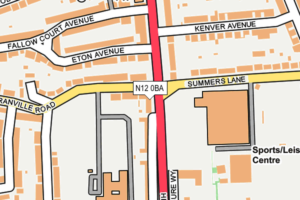
N12 0BA lies on High Road in London. N12 0BA is located in the West Finchley electoral ward, within the London borough of Barnet and the English Parliamentary constituency of Finchley and Golders Green. The Sub Integrated Care Board (ICB) Location is NHS North Central London ICB - 93C and the police force is Metropolitan Police. This postcode has been in use since May 2005.


GetTheData
Source: OS OpenMap – Local (Ordnance Survey)
Source: OS VectorMap District (Ordnance Survey)
Licence: Open Government Licence (requires attribution)
| Easting | 526455 |
| Northing | 191389 |
| Latitude | 51.607148 |
| Longitude | -0.175285 |
GetTheData
Source: Open Postcode Geo
Licence: Open Government Licence
| Street | High Road |
| Town/City | London |
| Country | England |
| Postcode District | N12 |
➜ See where N12 is on a map ➜ Where is Finchley? | |
GetTheData
Source: Land Registry Price Paid Data
Licence: Open Government Licence
Elevation or altitude of N12 0BA as distance above sea level:
| Metres | Feet | |
|---|---|---|
| Elevation | 80m | 262ft |
Elevation is measured from the approximate centre of the postcode, to the nearest point on an OS contour line from OS Terrain 50, which has contour spacing of ten vertical metres.
➜ How high above sea level am I? Find the elevation of your current position using your device's GPS.
GetTheData
Source: Open Postcode Elevation
Licence: Open Government Licence
| Ward | West Finchley |
| Constituency | Finchley And Golders Green |
GetTheData
Source: ONS Postcode Database
Licence: Open Government Licence
| Granville Rd High Rd Finchley (North Finchley High Road) | North Finchley | 86m |
| Granville Rd High Rd Finchley (North Finchley High Road) | North Finchley | 93m |
| Granville Rd High Rd Finchley (Summers Lane) | North Finchley | 121m |
| Granville Rd High Rd Finchley (Summers Lane) | North Finchley | 123m |
| Leisure Way (North Finchley High Road) | North Finchley | 154m |
| West Finchley Underground Station | West Finchley | 939m |
| Finchley Central Underground Station | Finchley Central | 1,379m |
| Woodside Park Underground Station | Woodside Park | 1,397m |
| New Southgate Station | 2.4km |
| Oakleigh Park Station | 3.5km |
| Bowes Park Station | 3.8km |
GetTheData
Source: NaPTAN
Licence: Open Government Licence
GetTheData
Source: ONS Postcode Database
Licence: Open Government Licence


➜ Get more ratings from the Food Standards Agency
GetTheData
Source: Food Standards Agency
Licence: FSA terms & conditions
| Last Collection | |||
|---|---|---|---|
| Location | Mon-Fri | Sat | Distance |
| High Road Post Office | 17:30 | 12:00 | 151m |
| Granville Road | 17:30 | 12:00 | 209m |
| Eaton Avenue | 17:30 | 12:00 | 233m |
GetTheData
Source: Dracos
Licence: Creative Commons Attribution-ShareAlike
The below table lists the International Territorial Level (ITL) codes (formerly Nomenclature of Territorial Units for Statistics (NUTS) codes) and Local Administrative Units (LAU) codes for N12 0BA:
| ITL 1 Code | Name |
|---|---|
| TLI | London |
| ITL 2 Code | Name |
| TLI7 | Outer London - West and North West |
| ITL 3 Code | Name |
| TLI71 | Barnet |
| LAU 1 Code | Name |
| E09000003 | Barnet |
GetTheData
Source: ONS Postcode Directory
Licence: Open Government Licence
The below table lists the Census Output Area (OA), Lower Layer Super Output Area (LSOA), and Middle Layer Super Output Area (MSOA) for N12 0BA:
| Code | Name | |
|---|---|---|
| OA | E00001541 | |
| LSOA | E01000316 | Barnet 027E |
| MSOA | E02000050 | Barnet 027 |
GetTheData
Source: ONS Postcode Directory
Licence: Open Government Licence
| N12 0JD | Granville Road | 46m |
| N12 0AY | High Road | 65m |
| N12 0AD | High Road | 100m |
| N12 0JG | Granville Road | 114m |
| N12 0DY | High Road | 149m |
| N12 0BD | Eton Avenue | 150m |
| N12 0BB | Eton Avenue | 160m |
| N12 0AX | High Road | 168m |
| N12 0EA | Fallow Court Avenue | 193m |
| N12 0AB | High Road | 202m |
GetTheData
Source: Open Postcode Geo; Land Registry Price Paid Data
Licence: Open Government Licence