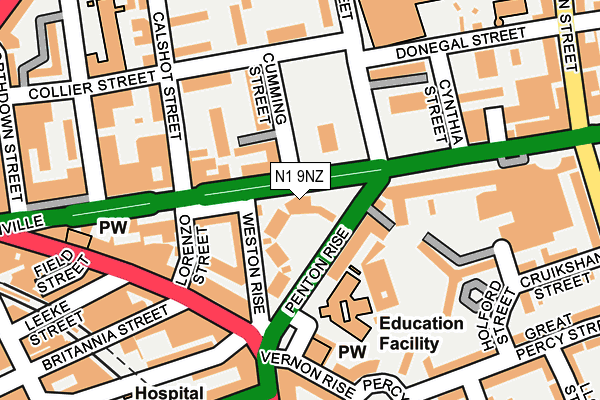
N1 9NZ is located in the Clerkenwell electoral ward, within the London borough of Islington and the English Parliamentary constituency of Islington South and Finsbury. The Sub Integrated Care Board (ICB) Location is NHS North Central London ICB - 93C and the police force is Metropolitan Police. This postcode has been in use since June 1997.


GetTheData
Source: OS OpenMap – Local (Ordnance Survey)
Source: OS VectorMap District (Ordnance Survey)
Licence: Open Government Licence (requires attribution)
| Easting | 530828 |
| Northing | 183039 |
| Latitude | 51.531110 |
| Longitude | -0.115304 |
GetTheData
Source: Open Postcode Geo
Licence: Open Government Licence
| Country | England |
| Postcode District | N1 |
➜ See where N1 is on a map ➜ Where is London? | |
GetTheData
Source: Land Registry Price Paid Data
Licence: Open Government Licence
Elevation or altitude of N1 9NZ as distance above sea level:
| Metres | Feet | |
|---|---|---|
| Elevation | 20m | 66ft |
Elevation is measured from the approximate centre of the postcode, to the nearest point on an OS contour line from OS Terrain 50, which has contour spacing of ten vertical metres.
➜ How high above sea level am I? Find the elevation of your current position using your device's GPS.
GetTheData
Source: Open Postcode Elevation
Licence: Open Government Licence
| Ward | Clerkenwell |
| Constituency | Islington South And Finsbury |
GetTheData
Source: ONS Postcode Database
Licence: Open Government Licence
| Penton Rise (Pentonville Road) | Pentonville | 11m |
| Penton Rise (Pentonville Road) | Pentonville | 39m |
| Penton Rise | Pentonville | 65m |
| King's Cross Rdpentonville Rd | Pentonville | 223m |
| Kings Cross Road | Pentonville | 226m |
| King's Cross St. Pancras Underground Station | King's Cross | 550m |
| Angel Underground Station | Angel | 674m |
| Russell Square Underground Station | Russell Square | 1,090m |
| Euston Underground Station | Euston | 1,328m |
| Farringdon Underground Station | Farringdon | 1,407m |
| London Kings Cross Station | 0.5km |
| London St Pancras International Station | 0.8km |
| London St Pancras International LL Station | 0.8km |
GetTheData
Source: NaPTAN
Licence: Open Government Licence
GetTheData
Source: ONS Postcode Database
Licence: Open Government Licence


➜ Get more ratings from the Food Standards Agency
GetTheData
Source: Food Standards Agency
Licence: FSA terms & conditions
| Last Collection | |||
|---|---|---|---|
| Location | Mon-Fri | Sat | Distance |
| Kings Cross Road (Britannia St) | 18:30 | 12:00 | 150m |
| 192 Pentonville Road | 18:30 | 12:00 | 152m |
| Amwell Street (O/S Tso) | 18:30 | 12:00 | 364m |
GetTheData
Source: Dracos
Licence: Creative Commons Attribution-ShareAlike
The below table lists the International Territorial Level (ITL) codes (formerly Nomenclature of Territorial Units for Statistics (NUTS) codes) and Local Administrative Units (LAU) codes for N1 9NZ:
| ITL 1 Code | Name |
|---|---|
| TLI | London |
| ITL 2 Code | Name |
| TLI4 | Inner London - East |
| ITL 3 Code | Name |
| TLI43 | Haringey and Islington |
| LAU 1 Code | Name |
| E09000019 | Islington |
GetTheData
Source: ONS Postcode Directory
Licence: Open Government Licence
The below table lists the Census Output Area (OA), Lower Layer Super Output Area (LSOA), and Middle Layer Super Output Area (MSOA) for N1 9NZ:
| Code | Name | |
|---|---|---|
| OA | E00013543 | |
| LSOA | E01002728 | Islington 021D |
| MSOA | E02000574 | Islington 021 |
GetTheData
Source: ONS Postcode Directory
Licence: Open Government Licence
| WC1X 9EF | Penton Rise | 11m |
| WC1X 9EG | Penton Rise | 28m |
| WC1X 9ED | Penton Rise | 35m |
| N1 9JL | Pentonville Road | 43m |
| WC1X 9EB | Penton Rise | 60m |
| N1 9HW | Cumming Street | 71m |
| WC1X 9EA | Penton Rise | 79m |
| N1 9JW | Calshot Street | 110m |
| N1 9JP | Pentonville Road | 111m |
| N1 9JA | Cumming Street | 115m |
GetTheData
Source: Open Postcode Geo; Land Registry Price Paid Data
Licence: Open Government Licence