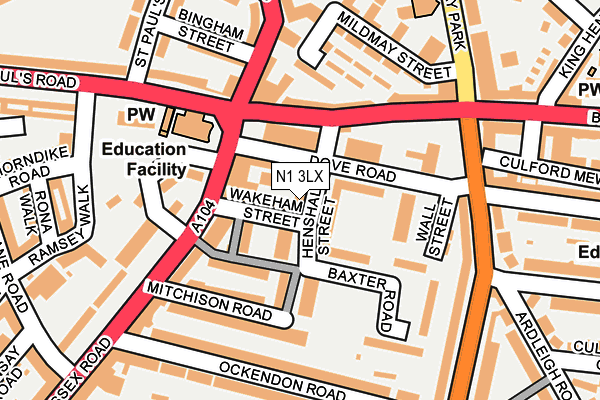
N1 3LX lies on Henshall Street in London. N1 3LX is located in the Canonbury electoral ward, within the London borough of Islington and the English Parliamentary constituency of Islington South and Finsbury. The Sub Integrated Care Board (ICB) Location is NHS North Central London ICB - 93C and the police force is Metropolitan Police. This postcode has been in use since January 1980.


GetTheData
Source: OS OpenMap – Local (Ordnance Survey)
Source: OS VectorMap District (Ordnance Survey)
Licence: Open Government Licence (requires attribution)
| Easting | 532801 |
| Northing | 184726 |
| Latitude | 51.545810 |
| Longitude | -0.086241 |
GetTheData
Source: Open Postcode Geo
Licence: Open Government Licence
| Street | Henshall Street |
| Town/City | London |
| Country | England |
| Postcode District | N1 |
➜ See where N1 is on a map ➜ Where is London? | |
GetTheData
Source: Land Registry Price Paid Data
Licence: Open Government Licence
Elevation or altitude of N1 3LX as distance above sea level:
| Metres | Feet | |
|---|---|---|
| Elevation | 20m | 66ft |
Elevation is measured from the approximate centre of the postcode, to the nearest point on an OS contour line from OS Terrain 50, which has contour spacing of ten vertical metres.
➜ How high above sea level am I? Find the elevation of your current position using your device's GPS.
GetTheData
Source: Open Postcode Elevation
Licence: Open Government Licence
| Ward | Canonbury |
| Constituency | Islington South And Finsbury |
GetTheData
Source: ONS Postcode Database
Licence: Open Government Licence
| Essex Road Newington Green Rd (Balls Pond Road) | Canonbury | 77m |
| Essex Road Marquess Road | Canonbury | 103m |
| Newington Green Balls Pond Rd (Newington Green Road) | Canonbury | 119m |
| St Paul's Road Ramsey Walk (St Paul's Road) | Canonbury | 132m |
| Newington Green Road Essex Rd (St Paul's Road) | Canonbury | 149m |
| Highbury & Islington Underground Station | Highbury & Islington | 1,186m |
| Canonbury Station | 0.5km |
| Dalston Junction Station | 0.8km |
| Dalston Kingsland Station | 0.8km |
GetTheData
Source: NaPTAN
Licence: Open Government Licence
| Percentage of properties with Next Generation Access | 100.0% |
| Percentage of properties with Superfast Broadband | 100.0% |
| Percentage of properties with Ultrafast Broadband | 75.0% |
| Percentage of properties with Full Fibre Broadband | 0.0% |
Superfast Broadband is between 30Mbps and 300Mbps
Ultrafast Broadband is > 300Mbps
| Percentage of properties unable to receive 2Mbps | 0.0% |
| Percentage of properties unable to receive 5Mbps | 0.0% |
| Percentage of properties unable to receive 10Mbps | 0.0% |
| Percentage of properties unable to receive 30Mbps | 0.0% |
GetTheData
Source: Ofcom
Licence: Ofcom Terms of Use (requires attribution)
Estimated total energy consumption in N1 3LX by fuel type, 2015.
| Consumption (kWh) | 21,200 |
|---|---|
| Meter count | 6 |
| Mean (kWh/meter) | 3,533 |
| Median (kWh/meter) | 3,509 |
GetTheData
Source: Postcode level gas estimates: 2015 (experimental)
Source: Postcode level electricity estimates: 2015 (experimental)
Licence: Open Government Licence
GetTheData
Source: ONS Postcode Database
Licence: Open Government Licence


➜ Get more ratings from the Food Standards Agency
GetTheData
Source: Food Standards Agency
Licence: FSA terms & conditions
| Last Collection | |||
|---|---|---|---|
| Location | Mon-Fri | Sat | Distance |
| Essex Road/St Pauls Road | 18:30 | 12:00 | 105m |
| 192 Southgate Road | 18:30 | 12:00 | 195m |
| Ockendonroad | 18:30 | 12:00 | 221m |
GetTheData
Source: Dracos
Licence: Creative Commons Attribution-ShareAlike
The below table lists the International Territorial Level (ITL) codes (formerly Nomenclature of Territorial Units for Statistics (NUTS) codes) and Local Administrative Units (LAU) codes for N1 3LX:
| ITL 1 Code | Name |
|---|---|
| TLI | London |
| ITL 2 Code | Name |
| TLI4 | Inner London - East |
| ITL 3 Code | Name |
| TLI43 | Haringey and Islington |
| LAU 1 Code | Name |
| E09000019 | Islington |
GetTheData
Source: ONS Postcode Directory
Licence: Open Government Licence
The below table lists the Census Output Area (OA), Lower Layer Super Output Area (LSOA), and Middle Layer Super Output Area (MSOA) for N1 3LX:
| Code | Name | |
|---|---|---|
| OA | E00013525 | |
| LSOA | E01002716 | Islington 014A |
| MSOA | E02000567 | Islington 014 |
GetTheData
Source: ONS Postcode Directory
Licence: Open Government Licence
| N1 3HP | Wakeham Street | 33m |
| N1 3HS | Baxter Road | 37m |
| N1 3QB | Callaby Terrace | 39m |
| N1 3PL | Dove Road | 58m |
| N1 3QE | Tilney Gardens | 65m |
| N1 3PJ | Essex Road | 68m |
| N1 3GH | Essex Road | 81m |
| N1 3QF | Tilney Gardens | 84m |
| N1 4AA | Balls Pond Road | 96m |
| N1 3QD | Greenhills Terrace | 97m |
GetTheData
Source: Open Postcode Geo; Land Registry Price Paid Data
Licence: Open Government Licence