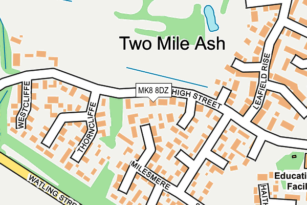
MK8 8DZ lies on The High Street in Two Mile Ash, Milton Keynes. MK8 8DZ is located in the Bradwell electoral ward, within the unitary authority of Milton Keynes and the English Parliamentary constituency of Milton Keynes South. The Sub Integrated Care Board (ICB) Location is NHS Bedfordshire, Luton and Milton Keynes ICB - M1J4Y and the police force is Thames Valley. This postcode has been in use since March 1982.


GetTheData
Source: OS OpenMap – Local (Ordnance Survey)
Source: OS VectorMap District (Ordnance Survey)
Licence: Open Government Licence (requires attribution)
| Easting | 481749 |
| Northing | 238539 |
| Latitude | 52.039235 |
| Longitude | -0.809585 |
GetTheData
Source: Open Postcode Geo
Licence: Open Government Licence
| Street | The High Street |
| Locality | Two Mile Ash |
| Town/City | Milton Keynes |
| Country | England |
| Postcode District | MK8 |
➜ See where MK8 is on a map ➜ Where is Milton Keynes? | |
GetTheData
Source: Land Registry Price Paid Data
Licence: Open Government Licence
Elevation or altitude of MK8 8DZ as distance above sea level:
| Metres | Feet | |
|---|---|---|
| Elevation | 90m | 295ft |
Elevation is measured from the approximate centre of the postcode, to the nearest point on an OS contour line from OS Terrain 50, which has contour spacing of ten vertical metres.
➜ How high above sea level am I? Find the elevation of your current position using your device's GPS.
GetTheData
Source: Open Postcode Elevation
Licence: Open Government Licence
| Ward | Bradwell |
| Constituency | Milton Keynes South |
GetTheData
Source: ONS Postcode Database
Licence: Open Government Licence
2023 28 APR £630,000 |
2015 24 JUL £420,000 |
18, THE HIGH STREET, TWO MILE ASH, MILTON KEYNES, MK8 8DZ 2006 10 MAR £292,000 |
2002 20 DEC £250,000 |
GetTheData
Source: HM Land Registry Price Paid Data
Licence: Contains HM Land Registry data © Crown copyright and database right 2025. This data is licensed under the Open Government Licence v3.0.
| The High Street West (The High Street (N)) | Two Mile Ash | 127m |
| The High Street West (The High Street (N)) | Two Mile Ash | 135m |
| Fairways | Two Mile Ash | 478m |
| Fairways | Two Mile Ash | 488m |
| Shorham Rise (Clay Hill) | Two Mile Ash | 501m |
| Milton Keynes Central Station | 2.5km |
| Wolverton Station | 3km |
GetTheData
Source: NaPTAN
Licence: Open Government Licence
| Percentage of properties with Next Generation Access | 100.0% |
| Percentage of properties with Superfast Broadband | 100.0% |
| Percentage of properties with Ultrafast Broadband | 100.0% |
| Percentage of properties with Full Fibre Broadband | 100.0% |
Superfast Broadband is between 30Mbps and 300Mbps
Ultrafast Broadband is > 300Mbps
| Percentage of properties unable to receive 2Mbps | 0.0% |
| Percentage of properties unable to receive 5Mbps | 0.0% |
| Percentage of properties unable to receive 10Mbps | 0.0% |
| Percentage of properties unable to receive 30Mbps | 0.0% |
GetTheData
Source: Ofcom
Licence: Ofcom Terms of Use (requires attribution)
GetTheData
Source: ONS Postcode Database
Licence: Open Government Licence


➜ Get more ratings from the Food Standards Agency
GetTheData
Source: Food Standards Agency
Licence: FSA terms & conditions
| Last Collection | |||
|---|---|---|---|
| Location | Mon-Fri | Sat | Distance |
| High Street | 17:30 | 12:00 | 30m |
| Badgemore Court | 17:15 | 12:00 | 496m |
| Post Office High Street | 17:00 | 12:00 | 540m |
GetTheData
Source: Dracos
Licence: Creative Commons Attribution-ShareAlike
The below table lists the International Territorial Level (ITL) codes (formerly Nomenclature of Territorial Units for Statistics (NUTS) codes) and Local Administrative Units (LAU) codes for MK8 8DZ:
| ITL 1 Code | Name |
|---|---|
| TLJ | South East (England) |
| ITL 2 Code | Name |
| TLJ1 | Berkshire, Buckinghamshire and Oxfordshire |
| ITL 3 Code | Name |
| TLJ12 | Milton Keynes |
| LAU 1 Code | Name |
| E06000042 | Milton Keynes |
GetTheData
Source: ONS Postcode Directory
Licence: Open Government Licence
The below table lists the Census Output Area (OA), Lower Layer Super Output Area (LSOA), and Middle Layer Super Output Area (MSOA) for MK8 8DZ:
| Code | Name | |
|---|---|---|
| OA | E00084824 | |
| LSOA | E01016816 | Milton Keynes 015D |
| MSOA | E02003473 | Milton Keynes 015 |
GetTheData
Source: ONS Postcode Directory
Licence: Open Government Licence
| MK8 8DS | Sedgemere | 58m |
| MK8 8DR | Littlemere | 105m |
| MK8 8EA | The High Street | 110m |
| MK8 8DJ | Stone Hill | 114m |
| MK8 8BZ | Cambron | 143m |
| MK8 8DP | Milesmere | 154m |
| MK8 8DH | Stone Hill | 157m |
| MK8 8DT | Thorncliffe | 164m |
| MK8 8DY | The High Street | 179m |
| MK8 8DQ | Fennymere | 181m |
GetTheData
Source: Open Postcode Geo; Land Registry Price Paid Data
Licence: Open Government Licence