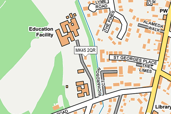
MK45 2QR is located in the Ampthill electoral ward, within the unitary authority of Central Bedfordshire and the English Parliamentary constituency of Mid Bedfordshire. The Sub Integrated Care Board (ICB) Location is NHS Bedfordshire, Luton and Milton Keynes ICB - M1J4Y and the police force is Bedfordshire. This postcode has been in use since January 1980.


GetTheData
Source: OS OpenMap – Local (Ordnance Survey)
Source: OS VectorMap District (Ordnance Survey)
Licence: Open Government Licence (requires attribution)
| Easting | 503082 |
| Northing | 237664 |
| Latitude | 52.027820 |
| Longitude | -0.498936 |
GetTheData
Source: Open Postcode Geo
Licence: Open Government Licence
| Country | England |
| Postcode District | MK45 |
➜ See where MK45 is on a map ➜ Where is Ampthill? | |
GetTheData
Source: Land Registry Price Paid Data
Licence: Open Government Licence
Elevation or altitude of MK45 2QR as distance above sea level:
| Metres | Feet | |
|---|---|---|
| Elevation | 90m | 295ft |
Elevation is measured from the approximate centre of the postcode, to the nearest point on an OS contour line from OS Terrain 50, which has contour spacing of ten vertical metres.
➜ How high above sea level am I? Find the elevation of your current position using your device's GPS.
GetTheData
Source: Open Postcode Elevation
Licence: Open Government Licence
| Ward | Ampthill |
| Constituency | Mid Bedfordshire |
GetTheData
Source: ONS Postcode Database
Licence: Open Government Licence
| Alameda Walk (Dunstable Street) | Ampthill | 277m |
| Lavender Court (Flitwick Road) | Ampthill | 289m |
| Sidney Road (Flitwick Road) | Ampthill | 292m |
| Alameda Walk (Dunstable Street) | Ampthill | 311m |
| Arthur Street (Oliver Street) | Ampthill | 354m |
| Flitwick Station | 2.7km |
| Millbrook (Beds) Station | 3.7km |
| Lidlington Station | 4.4km |
GetTheData
Source: NaPTAN
Licence: Open Government Licence
GetTheData
Source: ONS Postcode Database
Licence: Open Government Licence


➜ Get more ratings from the Food Standards Agency
GetTheData
Source: Food Standards Agency
Licence: FSA terms & conditions
| Last Collection | |||
|---|---|---|---|
| Location | Mon-Fri | Sat | Distance |
| Bedford Street | 17:30 | 10:20 | 637m |
| Post Office Church Street | 18:10 | 10:30 | 665m |
| Russell Drive | 17:30 | 10:45 | 686m |
GetTheData
Source: Dracos
Licence: Creative Commons Attribution-ShareAlike
The below table lists the International Territorial Level (ITL) codes (formerly Nomenclature of Territorial Units for Statistics (NUTS) codes) and Local Administrative Units (LAU) codes for MK45 2QR:
| ITL 1 Code | Name |
|---|---|
| TLH | East |
| ITL 2 Code | Name |
| TLH2 | Bedfordshire and Hertfordshire |
| ITL 3 Code | Name |
| TLH25 | Central Bedfordshire |
| LAU 1 Code | Name |
| E06000056 | Central Bedfordshire |
GetTheData
Source: ONS Postcode Directory
Licence: Open Government Licence
The below table lists the Census Output Area (OA), Lower Layer Super Output Area (LSOA), and Middle Layer Super Output Area (MSOA) for MK45 2QR:
| Code | Name | |
|---|---|---|
| OA | E00087750 | |
| LSOA | E01017375 | Central Bedfordshire 012E |
| MSOA | E02003610 | Central Bedfordshire 012 |
GetTheData
Source: ONS Postcode Directory
Licence: Open Government Licence
| MK45 2LQ | The Pines | 114m |
| MK45 2QP | Station Road | 151m |
| MK45 2GJ | Dunstable Street | 162m |
| MK45 2LA | Alameda Road | 165m |
| MK45 2LB | Lyme Road | 166m |
| MK45 2LH | Briar Close | 234m |
| MK45 2JX | Alameda Walk | 242m |
| MK45 2JT | Dunstable Street | 255m |
| MK45 2QU | Station Road | 267m |
| MK45 2JN | Manyweathers Court | 271m |
GetTheData
Source: Open Postcode Geo; Land Registry Price Paid Data
Licence: Open Government Licence