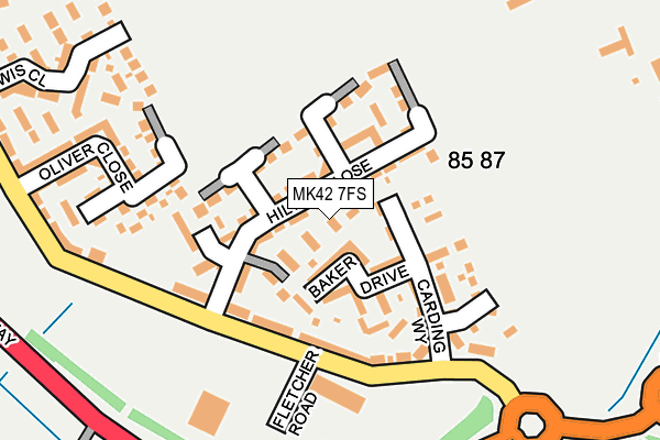
MK42 7FS lies on Hilton Close in Kempston, Bedford. MK42 7FS is located in the Kempston West electoral ward, within the unitary authority of Bedford and the English Parliamentary constituency of Bedford. The Sub Integrated Care Board (ICB) Location is NHS Bedfordshire, Luton and Milton Keynes ICB - M1J4Y and the police force is Bedfordshire. This postcode has been in use since July 2012.


GetTheData
Source: OS OpenMap – Local (Ordnance Survey)
Source: OS VectorMap District (Ordnance Survey)
Licence: Open Government Licence (requires attribution)
| Easting | 502354 |
| Northing | 246418 |
| Latitude | 52.106632 |
| Longitude | -0.506921 |
GetTheData
Source: Open Postcode Geo
Licence: Open Government Licence
| Street | Hilton Close |
| Locality | Kempston |
| Town/City | Bedford |
| Country | England |
| Postcode District | MK42 |
➜ See where MK42 is on a map ➜ Where is Kempston? | |
GetTheData
Source: Land Registry Price Paid Data
Licence: Open Government Licence
Elevation or altitude of MK42 7FS as distance above sea level:
| Metres | Feet | |
|---|---|---|
| Elevation | 30m | 98ft |
Elevation is measured from the approximate centre of the postcode, to the nearest point on an OS contour line from OS Terrain 50, which has contour spacing of ten vertical metres.
➜ How high above sea level am I? Find the elevation of your current position using your device's GPS.
GetTheData
Source: Open Postcode Elevation
Licence: Open Government Licence
| Ward | Kempston West |
| Constituency | Bedford |
GetTheData
Source: ONS Postcode Database
Licence: Open Government Licence
45, HILTON CLOSE, KEMPSTON, BEDFORD, MK42 7FS 2013 28 MAR £198,500 |
GetTheData
Source: HM Land Registry Price Paid Data
Licence: Contains HM Land Registry data © Crown copyright and database right 2025. This data is licensed under the Open Government Licence v3.0.
| Williamson Road Shops (Williamson Road) | Kempston | 512m |
| Williamson Road Shops (Williamson Road) | Kempston | 521m |
| Marsh Leys | Kempston | 527m |
| Hastings Road (Williamson Road) | Kempston | 602m |
| Hastings Road (Williamson Road) | Kempston | 627m |
| Kempston Hardwick Station | 1.6km |
| Bedford St Johns Station | 3.7km |
| Bedford Station | 3.8km |
GetTheData
Source: NaPTAN
Licence: Open Government Licence
| Percentage of properties with Next Generation Access | 98.1% |
| Percentage of properties with Superfast Broadband | 98.1% |
| Percentage of properties with Ultrafast Broadband | 98.1% |
| Percentage of properties with Full Fibre Broadband | 98.1% |
Superfast Broadband is between 30Mbps and 300Mbps
Ultrafast Broadband is > 300Mbps
| Median download speed | 7.2Mbps |
| Average download speed | 6.9Mbps |
| Maximum download speed | 9.73Mbps |
| Median upload speed | 0.8Mbps |
| Average upload speed | 0.8Mbps |
| Maximum upload speed | 1.15Mbps |
| Percentage of properties unable to receive 2Mbps | 0.0% |
| Percentage of properties unable to receive 5Mbps | 0.0% |
| Percentage of properties unable to receive 10Mbps | 1.9% |
| Percentage of properties unable to receive 30Mbps | 1.9% |
GetTheData
Source: Ofcom
Licence: Ofcom Terms of Use (requires attribution)
Estimated total energy consumption in MK42 7FS by fuel type, 2015.
| Consumption (kWh) | 434,923 |
|---|---|
| Meter count | 52 |
| Mean (kWh/meter) | 8,364 |
| Median (kWh/meter) | 6,668 |
| Consumption (kWh) | 95,096 |
|---|---|
| Meter count | 33 |
| Mean (kWh/meter) | 2,882 |
| Median (kWh/meter) | 2,331 |
GetTheData
Source: Postcode level gas estimates: 2015 (experimental)
Source: Postcode level electricity estimates: 2015 (experimental)
Licence: Open Government Licence
GetTheData
Source: ONS Postcode Database
Licence: Open Government Licence


➜ Get more ratings from the Food Standards Agency
GetTheData
Source: Food Standards Agency
Licence: FSA terms & conditions
| Last Collection | |||
|---|---|---|---|
| Location | Mon-Fri | Sat | Distance |
| Williamson Road | 18:05 | 11:35 | 494m |
| Singer Way | 18:45 | 11:55 | 666m |
| Singer Way | 18:15 | 01:00 | 685m |
GetTheData
Source: Dracos
Licence: Creative Commons Attribution-ShareAlike
The below table lists the International Territorial Level (ITL) codes (formerly Nomenclature of Territorial Units for Statistics (NUTS) codes) and Local Administrative Units (LAU) codes for MK42 7FS:
| ITL 1 Code | Name |
|---|---|
| TLH | East |
| ITL 2 Code | Name |
| TLH2 | Bedfordshire and Hertfordshire |
| ITL 3 Code | Name |
| TLH24 | Bedford |
| LAU 1 Code | Name |
| E06000055 | Bedford |
GetTheData
Source: ONS Postcode Directory
Licence: Open Government Licence
The below table lists the Census Output Area (OA), Lower Layer Super Output Area (LSOA), and Middle Layer Super Output Area (MSOA) for MK42 7FS:
| Code | Name | |
|---|---|---|
| OA | E00088425 | |
| LSOA | E01017516 | Bedford 018D |
| MSOA | E02003633 | Bedford 018 |
GetTheData
Source: ONS Postcode Directory
Licence: Open Government Licence
| MK42 7FT | Hilton Close | 43m |
| MK42 7GY | Baker Drive | 63m |
| MK42 7JZ | Carding Way | 94m |
| MK42 7GW | Walford Grove | 118m |
| MK42 7GZ | Crouch Gardens | 148m |
| MK42 7GX | Townsend Walk | 180m |
| MK42 7FW | Oliver Close | 204m |
| MK42 7HN | Haylock Close | 268m |
| MK42 7FX | Lewis Close | 279m |
| MK42 7HG | Dennis Road | 344m |
GetTheData
Source: Open Postcode Geo; Land Registry Price Paid Data
Licence: Open Government Licence