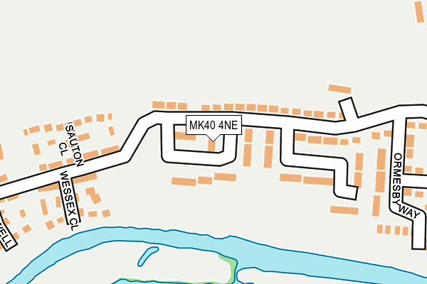
MK40 4NE lies on Wroxham Way in Bedford. MK40 4NE is located in the Queens Park electoral ward, within the unitary authority of Bedford and the English Parliamentary constituency of Bedford. The Sub Integrated Care Board (ICB) Location is NHS Bedfordshire, Luton and Milton Keynes ICB - M1J4Y and the police force is Bedfordshire. This postcode has been in use since January 1980.


GetTheData
Source: OS OpenMap – Local (Ordnance Survey)
Source: OS VectorMap District (Ordnance Survey)
Licence: Open Government Licence (requires attribution)
| Easting | 502903 |
| Northing | 249236 |
| Latitude | 52.131869 |
| Longitude | -0.498036 |
GetTheData
Source: Open Postcode Geo
Licence: Open Government Licence
| Street | Wroxham Way |
| Town/City | Bedford |
| Country | England |
| Postcode District | MK40 |
➜ See where MK40 is on a map ➜ Where is Bedford? | |
GetTheData
Source: Land Registry Price Paid Data
Licence: Open Government Licence
Elevation or altitude of MK40 4NE as distance above sea level:
| Metres | Feet | |
|---|---|---|
| Elevation | 30m | 98ft |
Elevation is measured from the approximate centre of the postcode, to the nearest point on an OS contour line from OS Terrain 50, which has contour spacing of ten vertical metres.
➜ How high above sea level am I? Find the elevation of your current position using your device's GPS.
GetTheData
Source: Open Postcode Elevation
Licence: Open Government Licence
| Ward | Queens Park |
| Constituency | Bedford |
GetTheData
Source: ONS Postcode Database
Licence: Open Government Licence
| Wroxham Way (Old Ford End Road) | Queens Park | 27m |
| Wroxham Way (Old Ford End Road) | Queens Park | 47m |
| Ormesby Way (Old Ford End Road) | Queens Park | 214m |
| Sauton Close (Greenkeepers Road) | Great Denham | 278m |
| Sauton Close (Greenkeepers Road) | Great Denham | 285m |
| Bedford Station | 1.4km |
| Bedford St Johns Station | 2.1km |
| Kempston Hardwick Station | 4.4km |
GetTheData
Source: NaPTAN
Licence: Open Government Licence
| Percentage of properties with Next Generation Access | 100.0% |
| Percentage of properties with Superfast Broadband | 100.0% |
| Percentage of properties with Ultrafast Broadband | 100.0% |
| Percentage of properties with Full Fibre Broadband | 0.0% |
Superfast Broadband is between 30Mbps and 300Mbps
Ultrafast Broadband is > 300Mbps
| Percentage of properties unable to receive 2Mbps | 0.0% |
| Percentage of properties unable to receive 5Mbps | 0.0% |
| Percentage of properties unable to receive 10Mbps | 0.0% |
| Percentage of properties unable to receive 30Mbps | 0.0% |
GetTheData
Source: Ofcom
Licence: Ofcom Terms of Use (requires attribution)
Estimated total energy consumption in MK40 4NE by fuel type, 2015.
| Consumption (kWh) | 45,478 |
|---|---|
| Meter count | 7 |
| Mean (kWh/meter) | 6,497 |
| Median (kWh/meter) | 4,759 |
GetTheData
Source: Postcode level gas estimates: 2015 (experimental)
Source: Postcode level electricity estimates: 2015 (experimental)
Licence: Open Government Licence
GetTheData
Source: ONS Postcode Database
Licence: Open Government Licence


➜ Get more ratings from the Food Standards Agency
GetTheData
Source: Food Standards Agency
Licence: FSA terms & conditions
| Last Collection | |||
|---|---|---|---|
| Location | Mon-Fri | Sat | Distance |
| Old Ford End Road | 18:00 | 12:30 | 219m |
| Hill Grounds Road | 17:30 | 11:30 | 584m |
| Biddenham Turn | 17:30 | 10:45 | 807m |
GetTheData
Source: Dracos
Licence: Creative Commons Attribution-ShareAlike
The below table lists the International Territorial Level (ITL) codes (formerly Nomenclature of Territorial Units for Statistics (NUTS) codes) and Local Administrative Units (LAU) codes for MK40 4NE:
| ITL 1 Code | Name |
|---|---|
| TLH | East |
| ITL 2 Code | Name |
| TLH2 | Bedfordshire and Hertfordshire |
| ITL 3 Code | Name |
| TLH24 | Bedford |
| LAU 1 Code | Name |
| E06000055 | Bedford |
GetTheData
Source: ONS Postcode Directory
Licence: Open Government Licence
The below table lists the Census Output Area (OA), Lower Layer Super Output Area (LSOA), and Middle Layer Super Output Area (MSOA) for MK40 4NE:
| Code | Name | |
|---|---|---|
| OA | E00088535 | |
| LSOA | E01017537 | Bedford 013C |
| MSOA | E02003628 | Bedford 013 |
GetTheData
Source: ONS Postcode Directory
Licence: Open Government Licence
| MK40 4NG | Old Ford End Road | 41m |
| MK40 4ND | Martham Close | 50m |
| MK40 4NB | Ranworth Walk | 59m |
| MK40 4NQ | Old Ford End Road | 76m |
| MK40 4NF | Old Ford End Road | 174m |
| MK40 4GY | Saunton Close | 193m |
| MK40 4RS | Wessex Close | 231m |
| MK40 4NA | Hickling Close | 244m |
| MK40 4RQ | Greenkeepers Road | 290m |
| MK40 4GW | Greenkeepers Road | 295m |
GetTheData
Source: Open Postcode Geo; Land Registry Price Paid Data
Licence: Open Government Licence