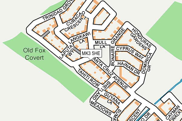
MK3 5HE lies on Santa Cruz Avenue in Newton Leys, Milton Keynes. MK3 5HE is located in the Bletchley East electoral ward, within the unitary authority of Milton Keynes and the English Parliamentary constituency of Milton Keynes South. The Sub Integrated Care Board (ICB) Location is NHS Bedfordshire, Luton and Milton Keynes ICB - M1J4Y and the police force is Thames Valley. This postcode has been in use since May 2015.


GetTheData
Source: OS OpenMap – Local (Ordnance Survey)
Source: OS VectorMap District (Ordnance Survey)
Licence: Open Government Licence (requires attribution)
| Easting | 486411 |
| Northing | 231305 |
| Latitude | 51.973516 |
| Longitude | -0.743435 |
GetTheData
Source: Open Postcode Geo
Licence: Open Government Licence
| Street | Santa Cruz Avenue |
| Locality | Newton Leys |
| Town/City | Milton Keynes |
| Country | England |
| Postcode District | MK3 |
➜ See where MK3 is on a map ➜ Where is Bletchley? | |
GetTheData
Source: Land Registry Price Paid Data
Licence: Open Government Licence
Elevation or altitude of MK3 5HE as distance above sea level:
| Metres | Feet | |
|---|---|---|
| Elevation | 90m | 295ft |
Elevation is measured from the approximate centre of the postcode, to the nearest point on an OS contour line from OS Terrain 50, which has contour spacing of ten vertical metres.
➜ How high above sea level am I? Find the elevation of your current position using your device's GPS.
GetTheData
Source: Open Postcode Elevation
Licence: Open Government Licence
| Ward | Bletchley East |
| Constituency | Milton Keynes South |
GetTheData
Source: ONS Postcode Database
Licence: Open Government Licence
73, SANTA CRUZ AVENUE, NEWTON LEYS, MILTON KEYNES, MK3 5HE 2023 27 SEP £491,000 |
79, SANTA CRUZ AVENUE, NEWTON LEYS, MILTON KEYNES, MK3 5HE 2023 14 SEP £515,000 |
59, SANTA CRUZ AVENUE, NEWTON LEYS, MILTON KEYNES, MK3 5HE 2017 26 JUN £335,000 |
GetTheData
Source: HM Land Registry Price Paid Data
Licence: Contains HM Land Registry data © Crown copyright and database right 2025. This data is licensed under the Open Government Licence v3.0.
| St Helena Avenue | Newton Leys | 688m |
| Tulla Court (Fern Grove) | Bletchley | 1,088m |
| Lomond Drive | Bletchley | 1,163m |
| Fern Grove | Bletchley | 1,315m |
| Sir Herbert Leon School (Fern Grove) | Bletchley | 1,415m |
| Bletchley Station | 2.5km |
| Fenny Stratford Station | 3.5km |
| Bow Brickhill Station | 4.7km |
GetTheData
Source: NaPTAN
Licence: Open Government Licence
| Percentage of properties with Next Generation Access | 81.7% |
| Percentage of properties with Superfast Broadband | 81.7% |
| Percentage of properties with Ultrafast Broadband | 81.7% |
| Percentage of properties with Full Fibre Broadband | 81.7% |
Superfast Broadband is between 30Mbps and 300Mbps
Ultrafast Broadband is > 300Mbps
| Percentage of properties unable to receive 2Mbps | 0.0% |
| Percentage of properties unable to receive 5Mbps | 18.3% |
| Percentage of properties unable to receive 10Mbps | 18.3% |
| Percentage of properties unable to receive 30Mbps | 18.3% |
GetTheData
Source: Ofcom
Licence: Ofcom Terms of Use (requires attribution)
Estimated total energy consumption in MK3 5HE by fuel type, 2015.
| Consumption (kWh) | 233,346 |
|---|---|
| Meter count | 30 |
| Mean (kWh/meter) | 7,778 |
| Median (kWh/meter) | 9,388 |
| Consumption (kWh) | 74,298 |
|---|---|
| Meter count | 40 |
| Mean (kWh/meter) | 1,857 |
| Median (kWh/meter) | 1,851 |
GetTheData
Source: Postcode level gas estimates: 2015 (experimental)
Source: Postcode level electricity estimates: 2015 (experimental)
Licence: Open Government Licence
GetTheData
Source: ONS Postcode Database
Licence: Open Government Licence


➜ Get more ratings from the Food Standards Agency
GetTheData
Source: Food Standards Agency
Licence: FSA terms & conditions
| Last Collection | |||
|---|---|---|---|
| Location | Mon-Fri | Sat | Distance |
| St. Lucia Crescent | 17:30 | 12:00 | 722m |
| Serpentine Court | 17:30 | 12:00 | 1,442m |
| Barton Road | 17:30 | 12:00 | 1,583m |
GetTheData
Source: Dracos
Licence: Creative Commons Attribution-ShareAlike
The below table lists the International Territorial Level (ITL) codes (formerly Nomenclature of Territorial Units for Statistics (NUTS) codes) and Local Administrative Units (LAU) codes for MK3 5HE:
| ITL 1 Code | Name |
|---|---|
| TLJ | South East (England) |
| ITL 2 Code | Name |
| TLJ1 | Berkshire, Buckinghamshire and Oxfordshire |
| ITL 3 Code | Name |
| TLJ12 | Milton Keynes |
| LAU 1 Code | Name |
| E06000042 | Milton Keynes |
GetTheData
Source: ONS Postcode Directory
Licence: Open Government Licence
The below table lists the Census Output Area (OA), Lower Layer Super Output Area (LSOA), and Middle Layer Super Output Area (MSOA) for MK3 5HE:
| Code | Name | |
|---|---|---|
| OA | E00175381 | |
| LSOA | E01016743 | Milton Keynes 032B |
| MSOA | E02003490 | Milton Keynes 032 |
GetTheData
Source: ONS Postcode Directory
Licence: Open Government Licence
| MK3 5PS | Langkawi Lane | 42m |
| MK3 5PW | Laputa Way | 53m |
| MK3 5LB | Trinidad Grove | 69m |
| MK3 5PT | Curacao Crescent | 79m |
| MK3 5GP | Bonaire Grange | 102m |
| MK3 5LG | Tahiti Row | 107m |
| MK3 5PL | Trinidad Grove | 127m |
| MK3 5GQ | Cyprus Way | 153m |
| MK3 5GL | Santa Cruz Avenue | 190m |
| MK3 5GR | Dominica Grove | 202m |
GetTheData
Source: Open Postcode Geo; Land Registry Price Paid Data
Licence: Open Government Licence