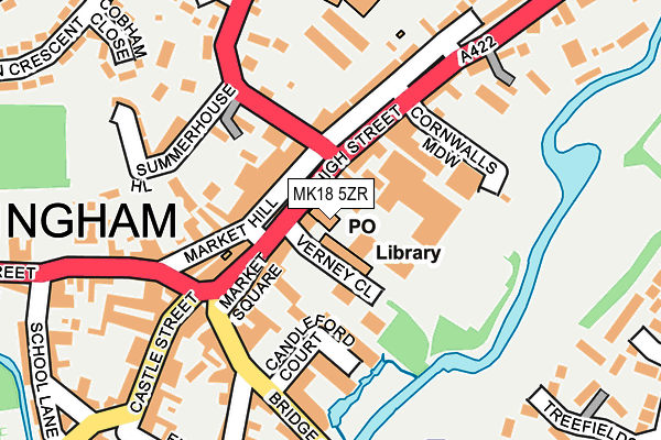
MK18 5ZR is located in the Buckingham East electoral ward, within the unitary authority of Buckinghamshire and the English Parliamentary constituency of Buckingham. The Sub Integrated Care Board (ICB) Location is NHS Buckinghamshire, Oxfordshire and Berkshire West ICB - 14Y and the police force is Thames Valley. This postcode has been in use since May 2004.


GetTheData
Source: OS OpenMap – Local (Ordnance Survey)
Source: OS VectorMap District (Ordnance Survey)
Licence: Open Government Licence (requires attribution)
| Easting | 469691 |
| Northing | 234045 |
| Latitude | 52.000482 |
| Longitude | -0.986261 |
GetTheData
Source: Open Postcode Geo
Licence: Open Government Licence
| Country | England |
| Postcode District | MK18 |
➜ See where MK18 is on a map ➜ Where is Buckingham? | |
GetTheData
Source: Land Registry Price Paid Data
Licence: Open Government Licence
Elevation or altitude of MK18 5ZR as distance above sea level:
| Metres | Feet | |
|---|---|---|
| Elevation | 80m | 262ft |
Elevation is measured from the approximate centre of the postcode, to the nearest point on an OS contour line from OS Terrain 50, which has contour spacing of ten vertical metres.
➜ How high above sea level am I? Find the elevation of your current position using your device's GPS.
GetTheData
Source: Open Postcode Elevation
Licence: Open Government Licence
| Ward | Buckingham East |
| Constituency | Buckingham |
GetTheData
Source: ONS Postcode Database
Licence: Open Government Licence
| Market Hill (Moreton Road) | Buckingham | 98m |
| Market Hill (Moreton Road) | Buckingham | 100m |
| High Street | Buckingham | 147m |
| Chandos Road (London Road) | Buckingham | 399m |
| Overn Avenue (Overn Ave) | Buckingham | 407m |
GetTheData
Source: NaPTAN
Licence: Open Government Licence
GetTheData
Source: ONS Postcode Database
Licence: Open Government Licence


➜ Get more ratings from the Food Standards Agency
GetTheData
Source: Food Standards Agency
Licence: FSA terms & conditions
| Last Collection | |||
|---|---|---|---|
| Location | Mon-Fri | Sat | Distance |
| Buckingham Delivery Office | 18:00 | 12:00 | 18m |
| Post Office Market Hill | 18:00 | 12:45 | 103m |
| Post Office Market Hill | 18:00 | 12:45 | 105m |
GetTheData
Source: Dracos
Licence: Creative Commons Attribution-ShareAlike
The below table lists the International Territorial Level (ITL) codes (formerly Nomenclature of Territorial Units for Statistics (NUTS) codes) and Local Administrative Units (LAU) codes for MK18 5ZR:
| ITL 1 Code | Name |
|---|---|
| TLJ | South East (England) |
| ITL 2 Code | Name |
| TLJ1 | Berkshire, Buckinghamshire and Oxfordshire |
| ITL 3 Code | Name |
| TLJ13 | Buckinghamshire |
| LAU 1 Code | Name |
| E06000060 | Buckinghamshire |
GetTheData
Source: ONS Postcode Directory
Licence: Open Government Licence
The below table lists the Census Output Area (OA), Lower Layer Super Output Area (LSOA), and Middle Layer Super Output Area (MSOA) for MK18 5ZR:
| Code | Name | |
|---|---|---|
| OA | E00089077 | |
| LSOA | E01017645 | Aylesbury Vale 002B |
| MSOA | E02003653 | Aylesbury Vale 002 |
GetTheData
Source: ONS Postcode Directory
Licence: Open Government Licence
| MK18 1UJ | Riverside Mews | 78m |
| MK18 1JX | Market Hill | 79m |
| MK18 1NJ | Market Square | 84m |
| MK18 1SB | Cornwall Place | 86m |
| MK18 1NW | Market Square | 100m |
| MK18 1GD | Candleford Court | 104m |
| MK18 1NT | High Street | 107m |
| MK18 1XG | Market Square | 110m |
| MK18 1NG | The Chewars | 113m |
| MK18 1NU | High Street | 129m |
GetTheData
Source: Open Postcode Geo; Land Registry Price Paid Data
Licence: Open Government Licence