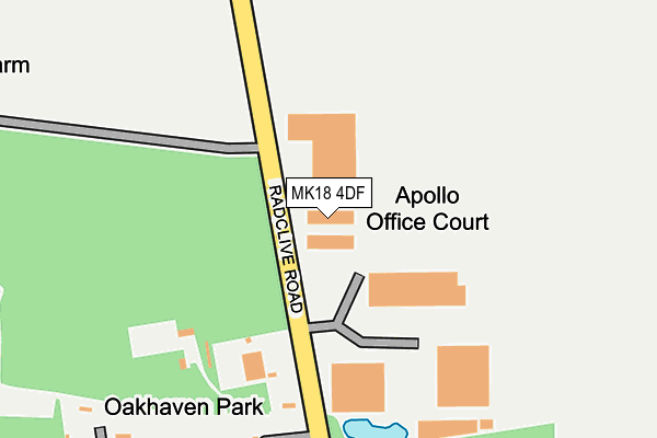
MK18 4DF lies on Radclive Road in Gawcott, Buckingham. MK18 4DF is located in the Buckingham West electoral ward, within the unitary authority of Buckinghamshire and the English Parliamentary constituency of Buckingham. The Sub Integrated Care Board (ICB) Location is NHS Buckinghamshire, Oxfordshire and Berkshire West ICB - 14Y and the police force is Thames Valley. This postcode has been in use since January 2008.


GetTheData
Source: OS OpenMap – Local (Ordnance Survey)
Source: OS VectorMap District (Ordnance Survey)
Licence: Open Government Licence (requires attribution)
| Easting | 467967 |
| Northing | 232849 |
| Latitude | 51.989944 |
| Longitude | -1.011606 |
GetTheData
Source: Open Postcode Geo
Licence: Open Government Licence
| Street | Radclive Road |
| Locality | Gawcott |
| Town/City | Buckingham |
| Country | England |
| Postcode District | MK18 |
➜ See where MK18 is on a map | |
GetTheData
Source: Land Registry Price Paid Data
Licence: Open Government Licence
Elevation or altitude of MK18 4DF as distance above sea level:
| Metres | Feet | |
|---|---|---|
| Elevation | 110m | 361ft |
Elevation is measured from the approximate centre of the postcode, to the nearest point on an OS contour line from OS Terrain 50, which has contour spacing of ten vertical metres.
➜ How high above sea level am I? Find the elevation of your current position using your device's GPS.
GetTheData
Source: Open Postcode Elevation
Licence: Open Government Licence
| Ward | Buckingham West |
| Constituency | Buckingham |
GetTheData
Source: ONS Postcode Database
Licence: Open Government Licence
| Post Office (Main Street) | Gawcott | 969m |
| Post Office (Main Street) | Gawcott | 976m |
| Village Hall (Buckingham Road) | Gawcott | 985m |
| Village Hall (Buckingham Road) | Gawcott | 991m |
| Primrose Way (Embleton Way) | Mount Pleasant | 1,173m |
GetTheData
Source: NaPTAN
Licence: Open Government Licence
GetTheData
Source: ONS Postcode Database
Licence: Open Government Licence


➜ Get more ratings from the Food Standards Agency
GetTheData
Source: Food Standards Agency
Licence: FSA terms & conditions
| Last Collection | |||
|---|---|---|---|
| Location | Mon-Fri | Sat | Distance |
| Buckingham Road | 16:00 | 09:45 | 1,042m |
| Back Street | 16:30 | 09:45 | 1,052m |
| Radclive | 16:30 | 06:45 | 1,247m |
GetTheData
Source: Dracos
Licence: Creative Commons Attribution-ShareAlike
The below table lists the International Territorial Level (ITL) codes (formerly Nomenclature of Territorial Units for Statistics (NUTS) codes) and Local Administrative Units (LAU) codes for MK18 4DF:
| ITL 1 Code | Name |
|---|---|
| TLJ | South East (England) |
| ITL 2 Code | Name |
| TLJ1 | Berkshire, Buckinghamshire and Oxfordshire |
| ITL 3 Code | Name |
| TLJ13 | Buckinghamshire |
| LAU 1 Code | Name |
| E06000060 | Buckinghamshire |
GetTheData
Source: ONS Postcode Directory
Licence: Open Government Licence
The below table lists the Census Output Area (OA), Lower Layer Super Output Area (LSOA), and Middle Layer Super Output Area (MSOA) for MK18 4DF:
| Code | Name | |
|---|---|---|
| OA | E00089402 | |
| LSOA | E01017718 | Aylesbury Vale 004F |
| MSOA | E02003655 | Aylesbury Vale 004 |
GetTheData
Source: ONS Postcode Directory
Licence: Open Government Licence
| MK18 4JB | Radclive Road | 287m |
| MK18 4AE | Tingewick Road | 754m |
| MK18 1TN | Gawcott Road | 786m |
| MK18 4JH | Old Barn Close | 906m |
| MK18 4HU | Hillside | 908m |
| MK18 4HX | Main Street | 939m |
| MK18 4JD | Buckingham Road | 966m |
| MK18 4HZ | Main Street | 970m |
| MK18 4FG | Leyland Close | 979m |
| MK18 1TL | Gawcott Fields | 980m |
GetTheData
Source: Open Postcode Geo; Land Registry Price Paid Data
Licence: Open Government Licence