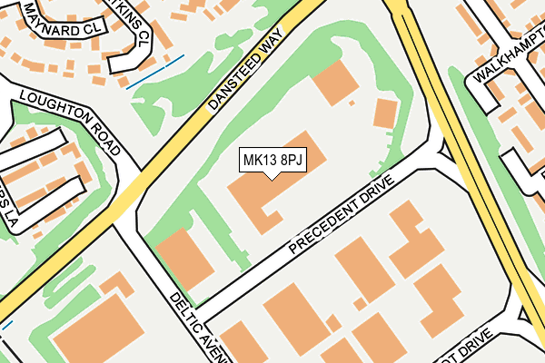
MK13 8PJ lies on Precedent Drive in Rooksley, Milton Keynes. MK13 8PJ is located in the Central Milton Keynes electoral ward, within the unitary authority of Milton Keynes and the English Parliamentary constituency of Milton Keynes North. The Sub Integrated Care Board (ICB) Location is NHS Bedfordshire, Luton and Milton Keynes ICB - M1J4Y and the police force is Thames Valley. This postcode has been in use since January 1992.


GetTheData
Source: OS OpenMap – Local (Ordnance Survey)
Source: OS VectorMap District (Ordnance Survey)
Licence: Open Government Licence (requires attribution)
| Easting | 483707 |
| Northing | 239062 |
| Latitude | 52.043645 |
| Longitude | -0.780918 |
GetTheData
Source: Open Postcode Geo
Licence: Open Government Licence
| Street | Precedent Drive |
| Locality | Rooksley |
| Town/City | Milton Keynes |
| Country | England |
| Postcode District | MK13 |
➜ See where MK13 is on a map ➜ Where is Milton Keynes? | |
GetTheData
Source: Land Registry Price Paid Data
Licence: Open Government Licence
Elevation or altitude of MK13 8PJ as distance above sea level:
| Metres | Feet | |
|---|---|---|
| Elevation | 90m | 295ft |
Elevation is measured from the approximate centre of the postcode, to the nearest point on an OS contour line from OS Terrain 50, which has contour spacing of ten vertical metres.
➜ How high above sea level am I? Find the elevation of your current position using your device's GPS.
GetTheData
Source: Open Postcode Elevation
Licence: Open Government Licence
| Ward | Central Milton Keynes |
| Constituency | Milton Keynes North |
GetTheData
Source: ONS Postcode Database
Licence: Open Government Licence
| Deltic Avenue (Dansteed Way H4) | Rooksley | 99m |
| Deltic Avenue (Dansteed Way H4) | Rooksley | 117m |
| Rooksley Roundabout South (Grafton Street V6) | Rooksley | 195m |
| Rooksley Roundabout South (Grafton Street V6) | Rooksley | 228m |
| Rooksley Roundabout North (Grafton Street V6) | Rooksley | 376m |
| Milton Keynes Central Station | 1.1km |
| Wolverton Station | 2.9km |
| Fenny Stratford Station | 6.6km |
GetTheData
Source: NaPTAN
Licence: Open Government Licence
GetTheData
Source: ONS Postcode Database
Licence: Open Government Licence


➜ Get more ratings from the Food Standards Agency
GetTheData
Source: Food Standards Agency
Licence: FSA terms & conditions
| Last Collection | |||
|---|---|---|---|
| Location | Mon-Fri | Sat | Distance |
| P | 18:30 | 157m | |
| Loughton Road | 17:00 | 12:00 | 318m |
| Bradwell Common Boulevard | 17:30 | 12:00 | 507m |
GetTheData
Source: Dracos
Licence: Creative Commons Attribution-ShareAlike
The below table lists the International Territorial Level (ITL) codes (formerly Nomenclature of Territorial Units for Statistics (NUTS) codes) and Local Administrative Units (LAU) codes for MK13 8PJ:
| ITL 1 Code | Name |
|---|---|
| TLJ | South East (England) |
| ITL 2 Code | Name |
| TLJ1 | Berkshire, Buckinghamshire and Oxfordshire |
| ITL 3 Code | Name |
| TLJ12 | Milton Keynes |
| LAU 1 Code | Name |
| E06000042 | Milton Keynes |
GetTheData
Source: ONS Postcode Directory
Licence: Open Government Licence
The below table lists the Census Output Area (OA), Lower Layer Super Output Area (LSOA), and Middle Layer Super Output Area (MSOA) for MK13 8PJ:
| Code | Name | |
|---|---|---|
| OA | E00084374 | |
| LSOA | E01016724 | Milton Keynes 013D |
| MSOA | E02003471 | Milton Keynes 013 |
GetTheData
Source: ONS Postcode Directory
Licence: Open Government Licence
| MK13 9HZ | Fosters Lane | 239m |
| MK13 9HT | Atkins Close | 241m |
| MK13 9HN | Ramsay Close | 254m |
| MK13 8ND | Walkhampton Avenue | 266m |
| MK13 8LU | Brill Place | 281m |
| MK13 9HS | Maynard Close | 282m |
| MK13 8NQ | Forrabury Avenue | 288m |
| MK13 8LT | Brill Place | 297m |
| MK13 9HH | Quinton Drive | 298m |
| MK13 9HW | Quinton Drive | 300m |
GetTheData
Source: Open Postcode Geo; Land Registry Price Paid Data
Licence: Open Government Licence