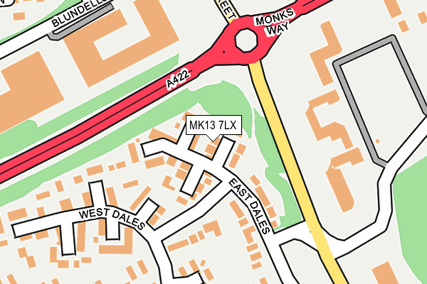
MK13 7LX lies on Dyersdale in Heelands, Milton Keynes. MK13 7LX is located in the Bradwell electoral ward, within the unitary authority of Milton Keynes and the English Parliamentary constituency of Milton Keynes North. The Sub Integrated Care Board (ICB) Location is NHS Bedfordshire, Luton and Milton Keynes ICB - M1J4Y and the police force is Thames Valley. This postcode has been in use since June 1981.


GetTheData
Source: OS OpenMap – Local (Ordnance Survey)
Source: OS VectorMap District (Ordnance Survey)
Licence: Open Government Licence (requires attribution)
| Easting | 484179 |
| Northing | 240484 |
| Latitude | 52.056355 |
| Longitude | -0.773688 |
GetTheData
Source: Open Postcode Geo
Licence: Open Government Licence
| Street | Dyersdale |
| Locality | Heelands |
| Town/City | Milton Keynes |
| Country | England |
| Postcode District | MK13 |
➜ See where MK13 is on a map ➜ Where is Milton Keynes? | |
GetTheData
Source: Land Registry Price Paid Data
Licence: Open Government Licence
Elevation or altitude of MK13 7LX as distance above sea level:
| Metres | Feet | |
|---|---|---|
| Elevation | 100m | 328ft |
Elevation is measured from the approximate centre of the postcode, to the nearest point on an OS contour line from OS Terrain 50, which has contour spacing of ten vertical metres.
➜ How high above sea level am I? Find the elevation of your current position using your device's GPS.
GetTheData
Source: Open Postcode Elevation
Licence: Open Government Licence
| Ward | Bradwell |
| Constituency | Milton Keynes North |
GetTheData
Source: ONS Postcode Database
Licence: Open Government Licence
| Stantonbury Roundabout South (Saxon Street V7) | Stantonbury | 82m |
| Stantonbury Roundabout West (Monks Way H3) | Stantonbury | 87m |
| Stantonbury Roundabout South (Saxon Street V7) | Stantonbury | 98m |
| Stantonbury Roundabout West (Monks Way H3) | Stantonbury | 120m |
| East Dales | Heelands | 161m |
| Wolverton Station | 2.3km |
| Milton Keynes Central Station | 2.5km |
GetTheData
Source: NaPTAN
Licence: Open Government Licence
| Percentage of properties with Next Generation Access | 100.0% |
| Percentage of properties with Superfast Broadband | 86.7% |
| Percentage of properties with Ultrafast Broadband | 0.0% |
| Percentage of properties with Full Fibre Broadband | 0.0% |
Superfast Broadband is between 30Mbps and 300Mbps
Ultrafast Broadband is > 300Mbps
| Median download speed | 25.1Mbps |
| Average download speed | 23.0Mbps |
| Maximum download speed | 35.00Mbps |
| Median upload speed | 5.3Mbps |
| Average upload speed | 4.9Mbps |
| Maximum upload speed | 8.44Mbps |
| Percentage of properties unable to receive 2Mbps | 0.0% |
| Percentage of properties unable to receive 5Mbps | 0.0% |
| Percentage of properties unable to receive 10Mbps | 0.0% |
| Percentage of properties unable to receive 30Mbps | 13.3% |
GetTheData
Source: Ofcom
Licence: Ofcom Terms of Use (requires attribution)
Estimated total energy consumption in MK13 7LX by fuel type, 2015.
| Consumption (kWh) | 240,067 |
|---|---|
| Meter count | 15 |
| Mean (kWh/meter) | 16,004 |
| Median (kWh/meter) | 14,928 |
| Consumption (kWh) | 47,580 |
|---|---|
| Meter count | 13 |
| Mean (kWh/meter) | 3,660 |
| Median (kWh/meter) | 3,553 |
GetTheData
Source: Postcode level gas estimates: 2015 (experimental)
Source: Postcode level electricity estimates: 2015 (experimental)
Licence: Open Government Licence
GetTheData
Source: ONS Postcode Database
Licence: Open Government Licence


➜ Get more ratings from the Food Standards Agency
GetTheData
Source: Food Standards Agency
Licence: FSA terms & conditions
| Last Collection | |||
|---|---|---|---|
| Location | Mon-Fri | Sat | Distance |
| Arncliffe Drive | 17:00 | 12:00 | 186m |
| Langcliffe Drive | 17:00 | 12:00 | 421m |
| Mercers Drive | 17:15 | 12:00 | 516m |
GetTheData
Source: Dracos
Licence: Creative Commons Attribution-ShareAlike
The below table lists the International Territorial Level (ITL) codes (formerly Nomenclature of Territorial Units for Statistics (NUTS) codes) and Local Administrative Units (LAU) codes for MK13 7LX:
| ITL 1 Code | Name |
|---|---|
| TLJ | South East (England) |
| ITL 2 Code | Name |
| TLJ1 | Berkshire, Buckinghamshire and Oxfordshire |
| ITL 3 Code | Name |
| TLJ12 | Milton Keynes |
| LAU 1 Code | Name |
| E06000042 | Milton Keynes |
GetTheData
Source: ONS Postcode Directory
Licence: Open Government Licence
The below table lists the Census Output Area (OA), Lower Layer Super Output Area (LSOA), and Middle Layer Super Output Area (MSOA) for MK13 7LX:
| Code | Name | |
|---|---|---|
| OA | E00084381 | |
| LSOA | E01016717 | Milton Keynes 013A |
| MSOA | E02003471 | Milton Keynes 013 |
GetTheData
Source: ONS Postcode Directory
Licence: Open Government Licence
| MK13 7LY | Deepdale | 23m |
| MK13 7NA | Bleasdale | 68m |
| MK13 7LZ | Coverdale | 84m |
| MK13 7PJ | East Dales | 110m |
| MK13 7NB | Stockdale | 133m |
| MK13 7PQ | Arncliffe Drive | 142m |
| MK13 7PH | East Dales | 144m |
| MK13 7ND | Scardale | 159m |
| MK13 7NQ | Gordale | 205m |
| MK13 7LE | Arncliffe Drive | 240m |
GetTheData
Source: Open Postcode Geo; Land Registry Price Paid Data
Licence: Open Government Licence