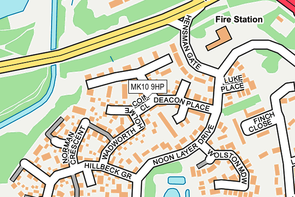
MK10 9HP lies on Coin Close in Middleton, Milton Keynes. MK10 9HP is located in the Broughton electoral ward, within the unitary authority of Milton Keynes and the English Parliamentary constituency of Milton Keynes North. The Sub Integrated Care Board (ICB) Location is NHS Bedfordshire, Luton and Milton Keynes ICB - M1J4Y and the police force is Thames Valley. This postcode has been in use since December 2001.


GetTheData
Source: OS OpenMap – Local (Ordnance Survey)
Source: OS VectorMap District (Ordnance Survey)
Licence: Open Government Licence (requires attribution)
| Easting | 488516 |
| Northing | 239449 |
| Latitude | 52.046377 |
| Longitude | -0.710719 |
GetTheData
Source: Open Postcode Geo
Licence: Open Government Licence
| Street | Coin Close |
| Locality | Middleton |
| Town/City | Milton Keynes |
| Country | England |
| Postcode District | MK10 |
➜ See where MK10 is on a map ➜ Where is Milton Keynes? | |
GetTheData
Source: Land Registry Price Paid Data
Licence: Open Government Licence
Elevation or altitude of MK10 9HP as distance above sea level:
| Metres | Feet | |
|---|---|---|
| Elevation | 60m | 197ft |
Elevation is measured from the approximate centre of the postcode, to the nearest point on an OS contour line from OS Terrain 50, which has contour spacing of ten vertical metres.
➜ How high above sea level am I? Find the elevation of your current position using your device's GPS.
GetTheData
Source: Open Postcode Elevation
Licence: Open Government Licence
| Ward | Broughton |
| Constituency | Milton Keynes North |
GetTheData
Source: ONS Postcode Database
Licence: Open Government Licence
| Fox Milne Roundabout West (Childs Way H6) | Fox Milne | 220m |
| Fox Milne Roundabout West (Childs Way H6) | Fox Milne | 221m |
| Bressingham Gate (Childs Way H6) | Northfield | 517m |
| Noon Layer Drive (Brickhill Street) | Middleton | 557m |
| Noon Layer Drive (Brickhill Street) | Middleton | 597m |
| Milton Keynes Central Station | 4.6km |
| Bow Brickhill Station | 4.8km |
| Woburn Sands Station | 5km |
GetTheData
Source: NaPTAN
Licence: Open Government Licence
| Percentage of properties with Next Generation Access | 100.0% |
| Percentage of properties with Superfast Broadband | 100.0% |
| Percentage of properties with Ultrafast Broadband | 100.0% |
| Percentage of properties with Full Fibre Broadband | 100.0% |
Superfast Broadband is between 30Mbps and 300Mbps
Ultrafast Broadband is > 300Mbps
| Percentage of properties unable to receive 2Mbps | 0.0% |
| Percentage of properties unable to receive 5Mbps | 0.0% |
| Percentage of properties unable to receive 10Mbps | 0.0% |
| Percentage of properties unable to receive 30Mbps | 0.0% |
GetTheData
Source: Ofcom
Licence: Ofcom Terms of Use (requires attribution)
GetTheData
Source: ONS Postcode Database
Licence: Open Government Licence


➜ Get more ratings from the Food Standards Agency
GetTheData
Source: Food Standards Agency
Licence: FSA terms & conditions
| Last Collection | |||
|---|---|---|---|
| Location | Mon-Fri | Sat | Distance |
| Noon Layer Drive | 17:30 | 12:00 | 140m |
| Opal Court, Opal Drive | 18:00 | 382m | |
| Milton Keynes Village | 17:00 | 12:45 | 631m |
GetTheData
Source: Dracos
Licence: Creative Commons Attribution-ShareAlike
The below table lists the International Territorial Level (ITL) codes (formerly Nomenclature of Territorial Units for Statistics (NUTS) codes) and Local Administrative Units (LAU) codes for MK10 9HP:
| ITL 1 Code | Name |
|---|---|
| TLJ | South East (England) |
| ITL 2 Code | Name |
| TLJ1 | Berkshire, Buckinghamshire and Oxfordshire |
| ITL 3 Code | Name |
| TLJ12 | Milton Keynes |
| LAU 1 Code | Name |
| E06000042 | Milton Keynes |
GetTheData
Source: ONS Postcode Directory
Licence: Open Government Licence
The below table lists the Census Output Area (OA), Lower Layer Super Output Area (LSOA), and Middle Layer Super Output Area (MSOA) for MK10 9HP:
| Code | Name | |
|---|---|---|
| OA | E00175413 | |
| LSOA | E01033503 | Milton Keynes 017F |
| MSOA | E02003475 | Milton Keynes 017 |
GetTheData
Source: ONS Postcode Directory
Licence: Open Government Licence
| MK10 9HN | Coin Close | 23m |
| MK10 9FS | Deacon Place | 48m |
| MK10 9FR | Deacon Place | 61m |
| MK10 9JR | Wadworth Holme | 80m |
| MK10 9FT | Deacon Place | 103m |
| MK10 9FQ | Noon Layer Drive | 104m |
| MK10 9FP | Noon Layer Drive | 126m |
| MK10 9JN | Norman Crescent | 138m |
| MK10 9BT | Noon Layer Drive | 164m |
| MK10 9JW | Savage Croft | 197m |
GetTheData
Source: Open Postcode Geo; Land Registry Price Paid Data
Licence: Open Government Licence