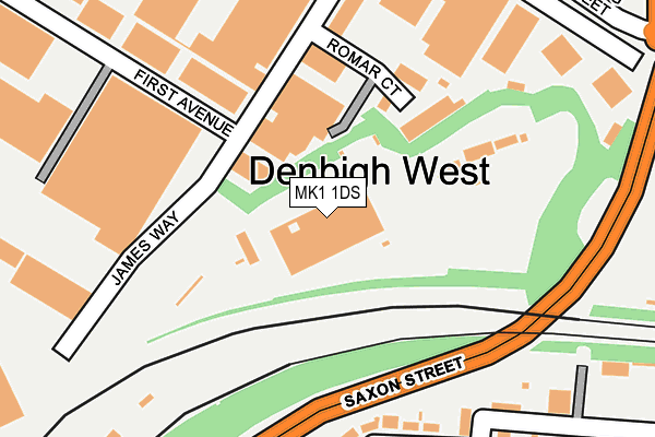
MK1 1DS is located in the Bletchley Park electoral ward, within the unitary authority of Milton Keynes and the English Parliamentary constituency of Milton Keynes South. The Sub Integrated Care Board (ICB) Location is NHS Bedfordshire, Luton and Milton Keynes ICB - M1J4Y and the police force is Thames Valley. This postcode has been in use since January 1980.


GetTheData
Source: OS OpenMap – Local (Ordnance Survey)
Source: OS VectorMap District (Ordnance Survey)
Licence: Open Government Licence (requires attribution)
| Easting | 487223 |
| Northing | 234404 |
| Latitude | 52.001235 |
| Longitude | -0.730852 |
GetTheData
Source: Open Postcode Geo
Licence: Open Government Licence
| Country | England |
| Postcode District | MK1 |
➜ See where MK1 is on a map ➜ Where is Bletchley? | |
GetTheData
Source: Land Registry Price Paid Data
Licence: Open Government Licence
Elevation or altitude of MK1 1DS as distance above sea level:
| Metres | Feet | |
|---|---|---|
| Elevation | 80m | 262ft |
Elevation is measured from the approximate centre of the postcode, to the nearest point on an OS contour line from OS Terrain 50, which has contour spacing of ten vertical metres.
➜ How high above sea level am I? Find the elevation of your current position using your device's GPS.
GetTheData
Source: Open Postcode Elevation
Licence: Open Government Licence
| Ward | Bletchley Park |
| Constituency | Milton Keynes South |
GetTheData
Source: ONS Postcode Database
Licence: Open Government Licence
| First Avenue (Denbigh Road) | Denbigh | 287m |
| Bletchley Tesco (Saxon Street V7) | Denbigh | 304m |
| First Avenue (Denbigh Road) | Denbigh | 305m |
| Bletchley Tesco (Saxon Street V7) | Denbigh | 324m |
| Denbigh North Retail Park (Bletcham Way H10) | Denbigh North | 452m |
| Bletchley Station | 0.8km |
| Fenny Stratford Station | 1km |
| Bow Brickhill Station | 2.4km |
GetTheData
Source: NaPTAN
Licence: Open Government Licence
GetTheData
Source: ONS Postcode Database
Licence: Open Government Licence


➜ Get more ratings from the Food Standards Agency
GetTheData
Source: Food Standards Agency
Licence: FSA terms & conditions
| Last Collection | |||
|---|---|---|---|
| Location | Mon-Fri | Sat | Distance |
| Denbigh Road | 18:30 | 12:00 | 278m |
| Dukes Drive | 18:30 | 12:00 | 311m |
| Western Road | 18:30 | 12:00 | 439m |
GetTheData
Source: Dracos
Licence: Creative Commons Attribution-ShareAlike
The below table lists the International Territorial Level (ITL) codes (formerly Nomenclature of Territorial Units for Statistics (NUTS) codes) and Local Administrative Units (LAU) codes for MK1 1DS:
| ITL 1 Code | Name |
|---|---|
| TLJ | South East (England) |
| ITL 2 Code | Name |
| TLJ1 | Berkshire, Buckinghamshire and Oxfordshire |
| ITL 3 Code | Name |
| TLJ12 | Milton Keynes |
| LAU 1 Code | Name |
| E06000042 | Milton Keynes |
GetTheData
Source: ONS Postcode Directory
Licence: Open Government Licence
The below table lists the Census Output Area (OA), Lower Layer Super Output Area (LSOA), and Middle Layer Super Output Area (MSOA) for MK1 1DS:
| Code | Name | |
|---|---|---|
| OA | E00084328 | |
| LSOA | E01033498 | Milton Keynes 023F |
| MSOA | E02003481 | Milton Keynes 023 |
GetTheData
Source: ONS Postcode Directory
Licence: Open Government Licence
| MK1 1RH | Romar Court | 116m |
| MK2 2QB | The Crescent | 194m |
| MK1 1DX | First Avenue | 206m |
| MK2 2QD | The Crescent | 229m |
| MK2 2QL | North Street | 272m |
| MK2 2JP | Saxon Street | 279m |
| MK1 1ED | Second Avenue | 297m |
| MK1 1SU | James Way | 303m |
| MK2 2QA | The Crescent | 305m |
| MK2 2PY | North Street | 312m |
GetTheData
Source: Open Postcode Geo; Land Registry Price Paid Data
Licence: Open Government Licence