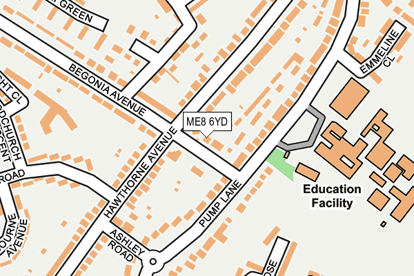
ME8 6YD lies on Begonia Avenue in Gillingham. ME8 6YD is located in the Rainham North electoral ward, within the unitary authority of Medway and the English Parliamentary constituency of Gillingham and Rainham. The Sub Integrated Care Board (ICB) Location is NHS Kent and Medway ICB - 91Q and the police force is Kent. This postcode has been in use since January 1980.


GetTheData
Source: OS OpenMap – Local (Ordnance Survey)
Source: OS VectorMap District (Ordnance Survey)
Licence: Open Government Licence (requires attribution)
| Easting | 580506 |
| Northing | 166765 |
| Latitude | 51.371251 |
| Longitude | 0.591904 |
GetTheData
Source: Open Postcode Geo
Licence: Open Government Licence
| Street | Begonia Avenue |
| Town/City | Gillingham |
| Country | England |
| Postcode District | ME8 |
➜ See where ME8 is on a map ➜ Where is Gillingham? | |
GetTheData
Source: Land Registry Price Paid Data
Licence: Open Government Licence
Elevation or altitude of ME8 6YD as distance above sea level:
| Metres | Feet | |
|---|---|---|
| Elevation | 50m | 164ft |
Elevation is measured from the approximate centre of the postcode, to the nearest point on an OS contour line from OS Terrain 50, which has contour spacing of ten vertical metres.
➜ How high above sea level am I? Find the elevation of your current position using your device's GPS.
GetTheData
Source: Open Postcode Elevation
Licence: Open Government Licence
| Ward | Rainham North |
| Constituency | Gillingham And Rainham |
GetTheData
Source: ONS Postcode Database
Licence: Open Government Licence
| Hawthorne Avenue (Begonia Avenue) | Twydall | 32m |
| Rainham Mark Grammar School (Pump Lane) | Twydall | 124m |
| Begonia Avenue | Twydall | 262m |
| Pump Lane Roundabout (Pump Lane) | Twydall | 318m |
| Beechings Green (Beechings Way) | Twydall | 370m |
| Rainham (Kent) Station | 1.5km |
| Gillingham (Kent) Station | 3.4km |
| Chatham Station | 5km |
GetTheData
Source: NaPTAN
Licence: Open Government Licence
| Percentage of properties with Next Generation Access | 100.0% |
| Percentage of properties with Superfast Broadband | 100.0% |
| Percentage of properties with Ultrafast Broadband | 100.0% |
| Percentage of properties with Full Fibre Broadband | 0.0% |
Superfast Broadband is between 30Mbps and 300Mbps
Ultrafast Broadband is > 300Mbps
| Percentage of properties unable to receive 2Mbps | 0.0% |
| Percentage of properties unable to receive 5Mbps | 0.0% |
| Percentage of properties unable to receive 10Mbps | 0.0% |
| Percentage of properties unable to receive 30Mbps | 0.0% |
GetTheData
Source: Ofcom
Licence: Ofcom Terms of Use (requires attribution)
GetTheData
Source: ONS Postcode Database
Licence: Open Government Licence


➜ Get more ratings from the Food Standards Agency
GetTheData
Source: Food Standards Agency
Licence: FSA terms & conditions
| Last Collection | |||
|---|---|---|---|
| Location | Mon-Fri | Sat | Distance |
| Pump Lane | 17:30 | 12:15 | 219m |
| Doddington Road | 17:30 | 12:00 | 321m |
| Millstead Road | 17:30 | 12:00 | 401m |
GetTheData
Source: Dracos
Licence: Creative Commons Attribution-ShareAlike
The below table lists the International Territorial Level (ITL) codes (formerly Nomenclature of Territorial Units for Statistics (NUTS) codes) and Local Administrative Units (LAU) codes for ME8 6YD:
| ITL 1 Code | Name |
|---|---|
| TLJ | South East (England) |
| ITL 2 Code | Name |
| TLJ4 | Kent |
| ITL 3 Code | Name |
| TLJ41 | Medway |
| LAU 1 Code | Name |
| E06000035 | Medway |
GetTheData
Source: ONS Postcode Directory
Licence: Open Government Licence
The below table lists the Census Output Area (OA), Lower Layer Super Output Area (LSOA), and Middle Layer Super Output Area (MSOA) for ME8 6YD:
| Code | Name | |
|---|---|---|
| OA | E00081708 | |
| LSOA | E01016166 | Medway 023C |
| MSOA | E02003336 | Medway 023 |
GetTheData
Source: ONS Postcode Directory
Licence: Open Government Licence
| ME8 6YE | Hawthorne Avenue | 57m |
| ME8 7AL | Pump Lane | 83m |
| ME8 6YA | Begonia Avenue | 96m |
| ME8 7AH | Pump Lane | 100m |
| ME8 6TU | Hawthorne Avenue | 104m |
| ME8 7AD | Pump Lane | 117m |
| ME8 6YF | Hawthorne Avenue | 155m |
| ME8 6SW | Newnham Close | 161m |
| ME8 6SN | Hollingbourne Road | 161m |
| ME8 6TT | Ashley Road | 174m |
GetTheData
Source: Open Postcode Geo; Land Registry Price Paid Data
Licence: Open Government Licence