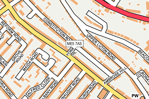
ME5 7AS lies on York Hill in Chatham. ME5 7AS is located in the Luton electoral ward, within the unitary authority of Medway and the English Parliamentary constituency of Chatham and Aylesford. The Sub Integrated Care Board (ICB) Location is NHS Kent and Medway ICB - 91Q and the police force is Kent. This postcode has been in use since June 1999.


GetTheData
Source: OS OpenMap – Local (Ordnance Survey)
Source: OS VectorMap District (Ordnance Survey)
Licence: Open Government Licence (requires attribution)
| Easting | 577059 |
| Northing | 166900 |
| Latitude | 51.373547 |
| Longitude | 0.542531 |
GetTheData
Source: Open Postcode Geo
Licence: Open Government Licence
| Street | York Hill |
| Town/City | Chatham |
| Country | England |
| Postcode District | ME5 |
➜ See where ME5 is on a map ➜ Where is Chatham? | |
GetTheData
Source: Land Registry Price Paid Data
Licence: Open Government Licence
Elevation or altitude of ME5 7AS as distance above sea level:
| Metres | Feet | |
|---|---|---|
| Elevation | 20m | 66ft |
Elevation is measured from the approximate centre of the postcode, to the nearest point on an OS contour line from OS Terrain 50, which has contour spacing of ten vertical metres.
➜ How high above sea level am I? Find the elevation of your current position using your device's GPS.
GetTheData
Source: Open Postcode Elevation
Licence: Open Government Licence
| Ward | Luton |
| Constituency | Chatham And Aylesford |
GetTheData
Source: ONS Postcode Database
Licence: Open Government Licence
| Albany Road (Luton Road) | Luton | 36m |
| Albany Road (Luton Road) | Luton | 49m |
| Luton Junior School (Luton Road) | Luton | 169m |
| Luton Junior School (Luton Road) | Luton | 225m |
| Castle Road (Luton Road) | Luton | 261m |
| Gillingham (Kent) Station | 1.5km |
| Chatham Station | 1.7km |
| Rochester Station | 2.6km |
GetTheData
Source: NaPTAN
Licence: Open Government Licence
| Percentage of properties with Next Generation Access | 100.0% |
| Percentage of properties with Superfast Broadband | 100.0% |
| Percentage of properties with Ultrafast Broadband | 100.0% |
| Percentage of properties with Full Fibre Broadband | 0.0% |
Superfast Broadband is between 30Mbps and 300Mbps
Ultrafast Broadband is > 300Mbps
| Percentage of properties unable to receive 2Mbps | 0.0% |
| Percentage of properties unable to receive 5Mbps | 0.0% |
| Percentage of properties unable to receive 10Mbps | 0.0% |
| Percentage of properties unable to receive 30Mbps | 0.0% |
GetTheData
Source: Ofcom
Licence: Ofcom Terms of Use (requires attribution)
GetTheData
Source: ONS Postcode Database
Licence: Open Government Licence


➜ Get more ratings from the Food Standards Agency
GetTheData
Source: Food Standards Agency
Licence: FSA terms & conditions
| Last Collection | |||
|---|---|---|---|
| Location | Mon-Fri | Sat | Distance |
| Edinburgh Road | 17:30 | 11:30 | 180m |
| Chatham Hill | 17:45 | 11:30 | 341m |
| Rainham Road Post Office | 17:30 | 11:30 | 486m |
GetTheData
Source: Dracos
Licence: Creative Commons Attribution-ShareAlike
The below table lists the International Territorial Level (ITL) codes (formerly Nomenclature of Territorial Units for Statistics (NUTS) codes) and Local Administrative Units (LAU) codes for ME5 7AS:
| ITL 1 Code | Name |
|---|---|
| TLJ | South East (England) |
| ITL 2 Code | Name |
| TLJ4 | Kent |
| ITL 3 Code | Name |
| TLJ41 | Medway |
| LAU 1 Code | Name |
| E06000035 | Medway |
GetTheData
Source: ONS Postcode Directory
Licence: Open Government Licence
The below table lists the Census Output Area (OA), Lower Layer Super Output Area (LSOA), and Middle Layer Super Output Area (MSOA) for ME5 7AS:
| Code | Name | |
|---|---|---|
| OA | E00081196 | |
| LSOA | E01016061 | Medway 020A |
| MSOA | E02003333 | Medway 020 |
GetTheData
Source: ONS Postcode Directory
Licence: Open Government Licence
| ME4 5BL | Luton Road | 54m |
| ME5 7BN | Merrimans View | 56m |
| ME5 7DW | Constitution Road | 57m |
| ME5 7BQ | Upper Luton Road | 81m |
| ME4 5BU | Luton Road | 84m |
| ME5 7DJ | Constitution Road | 90m |
| ME4 5BS | Luton Road | 97m |
| ME4 5BN | Luton Road | 102m |
| ME4 5BQ | Connaught Mews | 110m |
| ME5 7BW | Beacon Road | 123m |
GetTheData
Source: Open Postcode Geo; Land Registry Price Paid Data
Licence: Open Government Licence