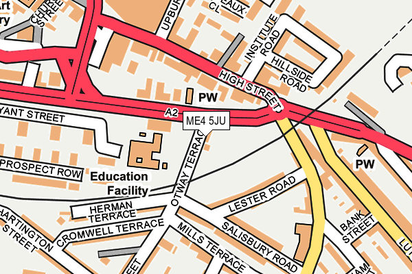
ME4 5JU lies on Otway Terrace in Chatham. ME4 5JU is located in the Chatham Central & Brompton electoral ward, within the unitary authority of Medway and the English Parliamentary constituency of Chatham and Aylesford. The Sub Integrated Care Board (ICB) Location is NHS Kent and Medway ICB - 91Q and the police force is Kent. This postcode has been in use since January 1980.


GetTheData
Source: OS OpenMap – Local (Ordnance Survey)
Source: OS VectorMap District (Ordnance Survey)
Licence: Open Government Licence (requires attribution)
| Easting | 576341 |
| Northing | 167427 |
| Latitude | 51.378505 |
| Longitude | 0.532459 |
GetTheData
Source: Open Postcode Geo
Licence: Open Government Licence
| Street | Otway Terrace |
| Town/City | Chatham |
| Country | England |
| Postcode District | ME4 |
➜ See where ME4 is on a map ➜ Where is Chatham? | |
GetTheData
Source: Land Registry Price Paid Data
Licence: Open Government Licence
Elevation or altitude of ME4 5JU as distance above sea level:
| Metres | Feet | |
|---|---|---|
| Elevation | 10m | 33ft |
Elevation is measured from the approximate centre of the postcode, to the nearest point on an OS contour line from OS Terrain 50, which has contour spacing of ten vertical metres.
➜ How high above sea level am I? Find the elevation of your current position using your device's GPS.
GetTheData
Source: Open Postcode Elevation
Licence: Open Government Licence
| Ward | Chatham Central & Brompton |
| Constituency | Chatham And Aylesford |
GetTheData
Source: ONS Postcode Database
Licence: Open Government Licence
5, OTWAY TERRACE, CHATHAM, ME4 5JU 2006 31 AUG £250,000 |
GetTheData
Source: HM Land Registry Price Paid Data
Licence: Contains HM Land Registry data © Crown copyright and database right 2025. This data is licensed under the Open Government Licence v3.0.
| Institute Road (High Street) | Chatham | 96m |
| Institute Road (High Street) | Chatham | 100m |
| High Street Gala Bingo (High Street) | Chatham | 180m |
| Newnham Street (Magpie Hall Road) | Chatham | 198m |
| Bank Street (Luton Road) | Luton | 200m |
| Chatham Station | 0.8km |
| Gillingham (Kent) Station | 1.5km |
| Rochester Station | 1.7km |
GetTheData
Source: NaPTAN
Licence: Open Government Licence
| Percentage of properties with Next Generation Access | 100.0% |
| Percentage of properties with Superfast Broadband | 100.0% |
| Percentage of properties with Ultrafast Broadband | 0.0% |
| Percentage of properties with Full Fibre Broadband | 0.0% |
Superfast Broadband is between 30Mbps and 300Mbps
Ultrafast Broadband is > 300Mbps
| Percentage of properties unable to receive 2Mbps | 0.0% |
| Percentage of properties unable to receive 5Mbps | 0.0% |
| Percentage of properties unable to receive 10Mbps | 0.0% |
| Percentage of properties unable to receive 30Mbps | 0.0% |
GetTheData
Source: Ofcom
Licence: Ofcom Terms of Use (requires attribution)
GetTheData
Source: ONS Postcode Database
Licence: Open Government Licence


➜ Get more ratings from the Food Standards Agency
GetTheData
Source: Food Standards Agency
Licence: FSA terms & conditions
| Last Collection | |||
|---|---|---|---|
| Location | Mon-Fri | Sat | Distance |
| Institute Road | 18:30 | 11:30 | 101m |
| Otway Street | 17:30 | 11:45 | 195m |
| Thorold Road | 17:45 | 11:30 | 246m |
GetTheData
Source: Dracos
Licence: Creative Commons Attribution-ShareAlike
The below table lists the International Territorial Level (ITL) codes (formerly Nomenclature of Territorial Units for Statistics (NUTS) codes) and Local Administrative Units (LAU) codes for ME4 5JU:
| ITL 1 Code | Name |
|---|---|
| TLJ | South East (England) |
| ITL 2 Code | Name |
| TLJ4 | Kent |
| ITL 3 Code | Name |
| TLJ41 | Medway |
| LAU 1 Code | Name |
| E06000035 | Medway |
GetTheData
Source: ONS Postcode Directory
Licence: Open Government Licence
The below table lists the Census Output Area (OA), Lower Layer Super Output Area (LSOA), and Middle Layer Super Output Area (MSOA) for ME4 5JU:
| Code | Name | |
|---|---|---|
| OA | E00081017 | |
| LSOA | E01016019 | Medway 015C |
| MSOA | E02003328 | Medway 015 |
GetTheData
Source: ONS Postcode Directory
Licence: Open Government Licence
| ME4 4NP | High Street | 99m |
| ME4 5NP | Lester Road | 107m |
| ME4 4QA | New Road | 111m |
| ME4 5NN | Salisbury Road | 113m |
| ME4 4NU | High Street | 121m |
| ME4 4PG | High Street | 129m |
| ME4 5NY | Mills Terrace | 155m |
| ME4 4PL | Arches View | 157m |
| ME4 4PF | Institute Road | 161m |
| ME4 5JY | Magpie Hall Road | 164m |
GetTheData
Source: Open Postcode Geo; Land Registry Price Paid Data
Licence: Open Government Licence