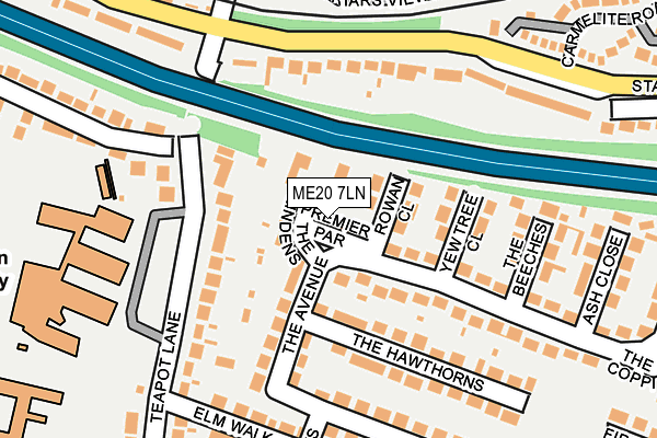
ME20 7LN lies on Premier Parade in Aylesford. ME20 7LN is located in the Aylesford South & Ditton electoral ward, within the local authority district of Tonbridge and Malling and the English Parliamentary constituency of Chatham and Aylesford. The Sub Integrated Care Board (ICB) Location is NHS Kent and Medway ICB - 91Q and the police force is Kent. This postcode has been in use since January 1980.


GetTheData
Source: OS OpenMap – Local (Ordnance Survey)
Source: OS VectorMap District (Ordnance Survey)
Licence: Open Government Licence (requires attribution)
| Easting | 572166 |
| Northing | 158487 |
| Latitude | 51.299474 |
| Longitude | 0.468209 |
GetTheData
Source: Open Postcode Geo
Licence: Open Government Licence
| Street | Premier Parade |
| Town/City | Aylesford |
| Country | England |
| Postcode District | ME20 |
➜ See where ME20 is on a map ➜ Where is Aylesford? | |
GetTheData
Source: Land Registry Price Paid Data
Licence: Open Government Licence
Elevation or altitude of ME20 7LN as distance above sea level:
| Metres | Feet | |
|---|---|---|
| Elevation | 10m | 33ft |
Elevation is measured from the approximate centre of the postcode, to the nearest point on an OS contour line from OS Terrain 50, which has contour spacing of ten vertical metres.
➜ How high above sea level am I? Find the elevation of your current position using your device's GPS.
GetTheData
Source: Open Postcode Elevation
Licence: Open Government Licence
| Ward | Aylesford South & Ditton |
| Constituency | Chatham And Aylesford |
GetTheData
Source: ONS Postcode Database
Licence: Open Government Licence
| School (Teapot Lane) | Aylesford | 183m |
| Sedley Close (Station Road) | Aylesford | 208m |
| Railway Station (Station Road) | Aylesford | 260m |
| Railway Station (Station Road) | Aylesford | 303m |
| Teapot Lane (London Road) | Aylesford | 390m |
| Aylesford Station | 0.2km |
| New Hythe Station | 1.8km |
| Barming Station | 1.8km |
GetTheData
Source: NaPTAN
Licence: Open Government Licence
GetTheData
Source: ONS Postcode Database
Licence: Open Government Licence


➜ Get more ratings from the Food Standards Agency
GetTheData
Source: Food Standards Agency
Licence: FSA terms & conditions
| Last Collection | |||
|---|---|---|---|
| Location | Mon-Fri | Sat | Distance |
| Premier Parade | 17:30 | 10:30 | 31m |
| Aylesford Station | 17:45 | 09:00 | 260m |
| Hall Road | 17:30 | 10:30 | 447m |
GetTheData
Source: Dracos
Licence: Creative Commons Attribution-ShareAlike
The below table lists the International Territorial Level (ITL) codes (formerly Nomenclature of Territorial Units for Statistics (NUTS) codes) and Local Administrative Units (LAU) codes for ME20 7LN:
| ITL 1 Code | Name |
|---|---|
| TLJ | South East (England) |
| ITL 2 Code | Name |
| TLJ4 | Kent |
| ITL 3 Code | Name |
| TLJ46 | West Kent |
| LAU 1 Code | Name |
| E07000115 | Tonbridge and Malling |
GetTheData
Source: ONS Postcode Directory
Licence: Open Government Licence
The below table lists the Census Output Area (OA), Lower Layer Super Output Area (LSOA), and Middle Layer Super Output Area (MSOA) for ME20 7LN:
| Code | Name | |
|---|---|---|
| OA | E00125470 | |
| LSOA | E01024719 | Tonbridge and Malling 001A |
| MSOA | E02005149 | Tonbridge and Malling 001 |
GetTheData
Source: ONS Postcode Directory
Licence: Open Government Licence
| ME20 7LW | Premier Parade Flats | 1m |
| ME20 7LL | The Lindens | 41m |
| ME20 7LP | Rowan Close | 75m |
| ME20 7RJ | Yew Tree Close | 107m |
| ME20 7JT | Teapot Lane | 110m |
| ME20 7LF | The Avenue | 110m |
| ME20 7LJ | The Hawthorns | 154m |
| ME20 7RQ | The Avenue | 154m |
| ME20 7RL | The Avenue | 160m |
| ME20 7JH | Station Road | 168m |
GetTheData
Source: Open Postcode Geo; Land Registry Price Paid Data
Licence: Open Government Licence