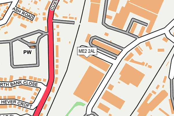
ME2 2AL is located in the Cuxton, Halling & Riverside electoral ward, within the unitary authority of Medway and the English Parliamentary constituency of Rochester and Strood. The Sub Integrated Care Board (ICB) Location is NHS Kent and Medway ICB - 91Q and the police force is Kent. This postcode has been in use since February 1990.


GetTheData
Source: OS OpenMap – Local (Ordnance Survey)
Source: OS VectorMap District (Ordnance Survey)
Licence: Open Government Licence (requires attribution)
| Easting | 573060 |
| Northing | 168508 |
| Latitude | 51.389225 |
| Longitude | 0.485888 |
GetTheData
Source: Open Postcode Geo
Licence: Open Government Licence
| Country | England |
| Postcode District | ME2 |
➜ See where ME2 is on a map ➜ Where is Rochester? | |
GetTheData
Source: Land Registry Price Paid Data
Licence: Open Government Licence
Elevation or altitude of ME2 2AL as distance above sea level:
| Metres | Feet | |
|---|---|---|
| Elevation | 20m | 66ft |
Elevation is measured from the approximate centre of the postcode, to the nearest point on an OS contour line from OS Terrain 50, which has contour spacing of ten vertical metres.
➜ How high above sea level am I? Find the elevation of your current position using your device's GPS.
GetTheData
Source: Open Postcode Elevation
Licence: Open Government Licence
| Ward | Cuxton, Halling & Riverside |
| Constituency | Rochester And Strood |
GetTheData
Source: ONS Postcode Database
Licence: Open Government Licence
| Poplar Road (Cuxton Road) | Strood | 197m |
| Hawthorn Road (Cuxton Road) | Strood | 219m |
| Poplar Road (Cuxton Road) | Strood | 226m |
| Hawthorn Road (Cuxton Road) | Strood | 253m |
| Darnley Arch (Cuxton Road) | Strood | 391m |
| Strood Station | 1.3km |
| Rochester Station | 1.7km |
| Cuxton Station | 2.4km |
GetTheData
Source: NaPTAN
Licence: Open Government Licence
GetTheData
Source: ONS Postcode Database
Licence: Open Government Licence


➜ Get more ratings from the Food Standards Agency
GetTheData
Source: Food Standards Agency
Licence: FSA terms & conditions
| Last Collection | |||
|---|---|---|---|
| Location | Mon-Fri | Sat | Distance |
| Cuxton Road | 17:30 | 12:00 | 119m |
| Medway Mail Centre | 19:15 | 11:30 | 173m |
| Medway Mail Centre | 19:15 | 11:30 | 174m |
GetTheData
Source: Dracos
Licence: Creative Commons Attribution-ShareAlike
The below table lists the International Territorial Level (ITL) codes (formerly Nomenclature of Territorial Units for Statistics (NUTS) codes) and Local Administrative Units (LAU) codes for ME2 2AL:
| ITL 1 Code | Name |
|---|---|
| TLJ | South East (England) |
| ITL 2 Code | Name |
| TLJ4 | Kent |
| ITL 3 Code | Name |
| TLJ41 | Medway |
| LAU 1 Code | Name |
| E06000035 | Medway |
GetTheData
Source: ONS Postcode Directory
Licence: Open Government Licence
The below table lists the Census Output Area (OA), Lower Layer Super Output Area (LSOA), and Middle Layer Super Output Area (MSOA) for ME2 2AL:
| Code | Name | |
|---|---|---|
| OA | E00081648 | |
| LSOA | E01016157 | Medway 011D |
| MSOA | E02003324 | Medway 011 |
GetTheData
Source: ONS Postcode Directory
Licence: Open Government Licence
| ME2 2NJ | Cuxton Road | 136m |
| ME2 2NQ | Temple Gardens | 162m |
| ME2 2LS | Knights Park Industrial Estate | 181m |
| ME2 2AW | Storway Court | 181m |
| ME2 2NH | Cuxton Road | 214m |
| ME2 2HL | Hawthorn Road | 260m |
| ME2 2JL | Ash Road | 261m |
| ME2 2NG | Temple Gardens | 272m |
| ME2 2NL | North Bank Close | 289m |
| ME2 2JJ | Cedar Road | 310m |
GetTheData
Source: Open Postcode Geo; Land Registry Price Paid Data
Licence: Open Government Licence