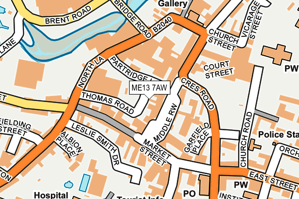
ME13 7AW is located in the Abbey electoral ward, within the local authority district of Swale and the English Parliamentary constituency of Faversham and Mid Kent. The Sub Integrated Care Board (ICB) Location is NHS Kent and Medway ICB - 91Q and the police force is Kent. This postcode has been in use since January 1980.


GetTheData
Source: OS OpenMap – Local (Ordnance Survey)
Source: OS VectorMap District (Ordnance Survey)
Licence: Open Government Licence (requires attribution)
| Easting | 601568 |
| Northing | 161448 |
| Latitude | 51.316424 |
| Longitude | 0.891097 |
GetTheData
Source: Open Postcode Geo
Licence: Open Government Licence
| Country | England |
| Postcode District | ME13 |
➜ See where ME13 is on a map | |
GetTheData
Source: Land Registry Price Paid Data
Licence: Open Government Licence
Elevation or altitude of ME13 7AW as distance above sea level:
| Metres | Feet | |
|---|---|---|
| Elevation | 10m | 33ft |
Elevation is measured from the approximate centre of the postcode, to the nearest point on an OS contour line from OS Terrain 50, which has contour spacing of ten vertical metres.
➜ How high above sea level am I? Find the elevation of your current position using your device's GPS.
GetTheData
Source: Open Postcode Elevation
Licence: Open Government Licence
| Ward | Abbey |
| Constituency | Faversham And Mid Kent |
GetTheData
Source: ONS Postcode Database
Licence: Open Government Licence
| Court Street | Faversham | 98m |
| Crescent Road | Faversham | 116m |
| North Lane | Faversham | 149m |
| East Street | Faversham | 257m |
| Newton Road Library (Newton Road) | Faversham | 267m |
| Faversham Station | 0.5km |
| Selling Station | 5.6km |
GetTheData
Source: NaPTAN
Licence: Open Government Licence
GetTheData
Source: ONS Postcode Database
Licence: Open Government Licence


➜ Get more ratings from the Food Standards Agency
GetTheData
Source: Food Standards Agency
Licence: FSA terms & conditions
| Last Collection | |||
|---|---|---|---|
| Location | Mon-Fri | Sat | Distance |
| Court Street | 17:30 | 11:15 | 56m |
| North Lane | 17:30 | 11:00 | 149m |
| East Street Post Office | 18:30 | 12:15 | 189m |
GetTheData
Source: Dracos
Licence: Creative Commons Attribution-ShareAlike
The below table lists the International Territorial Level (ITL) codes (formerly Nomenclature of Territorial Units for Statistics (NUTS) codes) and Local Administrative Units (LAU) codes for ME13 7AW:
| ITL 1 Code | Name |
|---|---|
| TLJ | South East (England) |
| ITL 2 Code | Name |
| TLJ4 | Kent |
| ITL 3 Code | Name |
| TLJ43 | Kent Thames Gateway |
| LAU 1 Code | Name |
| E07000113 | Swale |
GetTheData
Source: ONS Postcode Directory
Licence: Open Government Licence
The below table lists the Census Output Area (OA), Lower Layer Super Output Area (LSOA), and Middle Layer Super Output Area (MSOA) for ME13 7AW:
| Code | Name | |
|---|---|---|
| OA | E00124618 | |
| LSOA | E01024553 | Swale 015C |
| MSOA | E02005129 | Swale 015 |
GetTheData
Source: ONS Postcode Directory
Licence: Open Government Licence
| ME13 7AN | Court Street | 15m |
| ME13 7DX | Partridge Lane | 32m |
| ME13 7AL | Court Street | 46m |
| ME13 7AG | Market Place | 52m |
| ME13 7EN | Thomas Road | 80m |
| ME13 7JB | West Street | 89m |
| ME13 7AE | Market Place | 90m |
| ME13 7ED | Gange Mews | 92m |
| ME13 7JX | Water Lane | 93m |
| ME13 7JE | West Street | 96m |
GetTheData
Source: Open Postcode Geo; Land Registry Price Paid Data
Licence: Open Government Licence