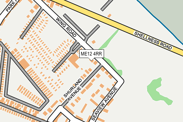
ME12 4RR lies on Wing Road in Leysdown On Sea, Sheerness. ME12 4RR is located in the Sheppey East electoral ward, within the local authority district of Swale and the English Parliamentary constituency of Sittingbourne and Sheppey. The Sub Integrated Care Board (ICB) Location is NHS Kent and Medway ICB - 91Q and the police force is Kent. This postcode has been in use since June 1981.


GetTheData
Source: OS OpenMap – Local (Ordnance Survey)
Source: OS VectorMap District (Ordnance Survey)
Licence: Open Government Licence (requires attribution)
| Easting | 603707 |
| Northing | 170210 |
| Latitude | 51.394345 |
| Longitude | 0.926762 |
GetTheData
Source: Open Postcode Geo
Licence: Open Government Licence
| Street | Wing Road |
| Locality | Leysdown On Sea |
| Town/City | Sheerness |
| Country | England |
| Postcode District | ME12 |
➜ See where ME12 is on a map ➜ Where is Leysdown-on-Sea? | |
GetTheData
Source: Land Registry Price Paid Data
Licence: Open Government Licence
Elevation or altitude of ME12 4RR as distance above sea level:
| Metres | Feet | |
|---|---|---|
| Elevation | 10m | 33ft |
Elevation is measured from the approximate centre of the postcode, to the nearest point on an OS contour line from OS Terrain 50, which has contour spacing of ten vertical metres.
➜ How high above sea level am I? Find the elevation of your current position using your device's GPS.
GetTheData
Source: Open Postcode Elevation
Licence: Open Government Licence
| Ward | Sheppey East |
| Constituency | Sittingbourne And Sheppey |
GetTheData
Source: ONS Postcode Database
Licence: Open Government Licence
| Bus Terminus (Shellness Road) | Leysdown | 293m |
| Nutts Avenue (Leysdown Road) | Leysdown | 368m |
| Rose And Crown (Leysdown Road) | Leysdown | 464m |
| Shops (Leysdown Road) | Leysdown | 598m |
| Vanity Holiday Park (Leysdown Road) | Leysdown | 844m |
GetTheData
Source: NaPTAN
Licence: Open Government Licence
| Percentage of properties with Next Generation Access | 100.0% |
| Percentage of properties with Superfast Broadband | 100.0% |
| Percentage of properties with Ultrafast Broadband | 0.0% |
| Percentage of properties with Full Fibre Broadband | 0.0% |
Superfast Broadband is between 30Mbps and 300Mbps
Ultrafast Broadband is > 300Mbps
| Percentage of properties unable to receive 2Mbps | 0.0% |
| Percentage of properties unable to receive 5Mbps | 0.0% |
| Percentage of properties unable to receive 10Mbps | 0.0% |
| Percentage of properties unable to receive 30Mbps | 0.0% |
GetTheData
Source: Ofcom
Licence: Ofcom Terms of Use (requires attribution)
GetTheData
Source: ONS Postcode Database
Licence: Open Government Licence


➜ Get more ratings from the Food Standards Agency
GetTheData
Source: Food Standards Agency
Licence: FSA terms & conditions
| Last Collection | |||
|---|---|---|---|
| Location | Mon-Fri | Sat | Distance |
| Leysdown On Sea Post Office | 16:00 | 10:45 | 530m |
| Warden Bay | 16:00 | 09:00 | 1,738m |
| Bayview Estate | 16:00 | 11:15 | 1,898m |
GetTheData
Source: Dracos
Licence: Creative Commons Attribution-ShareAlike
The below table lists the International Territorial Level (ITL) codes (formerly Nomenclature of Territorial Units for Statistics (NUTS) codes) and Local Administrative Units (LAU) codes for ME12 4RR:
| ITL 1 Code | Name |
|---|---|
| TLJ | South East (England) |
| ITL 2 Code | Name |
| TLJ4 | Kent |
| ITL 3 Code | Name |
| TLJ43 | Kent Thames Gateway |
| LAU 1 Code | Name |
| E07000113 | Swale |
GetTheData
Source: ONS Postcode Directory
Licence: Open Government Licence
The below table lists the Census Output Area (OA), Lower Layer Super Output Area (LSOA), and Middle Layer Super Output Area (MSOA) for ME12 4RR:
| Code | Name | |
|---|---|---|
| OA | E00124757 | |
| LSOA | E01024580 | Swale 006A |
| MSOA | E02005120 | Swale 006 |
GetTheData
Source: ONS Postcode Directory
Licence: Open Government Licence
| ME12 4QX | Wing Road | 42m |
| ME12 4QU | Shurland Avenue | 132m |
| ME12 4RA | Seaview Avenue | 162m |
| ME12 4RH | Shellness Road | 221m |
| ME12 4RS | James Court | 245m |
| ME12 4QR | Wing Road | 254m |
| ME12 4QP | Park Avenue Holiday Village | 308m |
| ME12 4QN | Park Avenue | 315m |
| ME12 4QJ | Park Avenue | 350m |
| ME12 4RD | Leysdown Road | 351m |
GetTheData
Source: Open Postcode Geo; Land Registry Price Paid Data
Licence: Open Government Licence