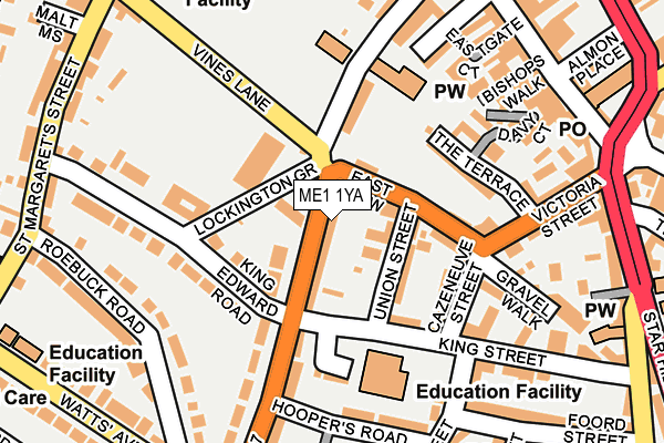
ME1 1YA lies on Pleasant Row in Rochester. ME1 1YA is located in the Rochester West & Borstal electoral ward, within the unitary authority of Medway and the English Parliamentary constituency of Rochester and Strood. The Sub Integrated Care Board (ICB) Location is NHS Kent and Medway ICB - 91Q and the police force is Kent. This postcode has been in use since January 1980.


GetTheData
Source: OS OpenMap – Local (Ordnance Survey)
Source: OS VectorMap District (Ordnance Survey)
Licence: Open Government Licence (requires attribution)
| Easting | 574336 |
| Northing | 168103 |
| Latitude | 51.385196 |
| Longitude | 0.504010 |
GetTheData
Source: Open Postcode Geo
Licence: Open Government Licence
| Street | Pleasant Row |
| Town/City | Rochester |
| Country | England |
| Postcode District | ME1 |
➜ See where ME1 is on a map ➜ Where is Rochester? | |
GetTheData
Source: Land Registry Price Paid Data
Licence: Open Government Licence
Elevation or altitude of ME1 1YA as distance above sea level:
| Metres | Feet | |
|---|---|---|
| Elevation | 20m | 66ft |
Elevation is measured from the approximate centre of the postcode, to the nearest point on an OS contour line from OS Terrain 50, which has contour spacing of ten vertical metres.
➜ How high above sea level am I? Find the elevation of your current position using your device's GPS.
GetTheData
Source: Open Postcode Elevation
Licence: Open Government Licence
| Ward | Rochester West & Borstal |
| Constituency | Rochester And Strood |
GetTheData
Source: ONS Postcode Database
Licence: Open Government Licence
IVY HOUSE, PLEASANT ROW, ROCHESTER, ME1 1YA 2002 26 JUL £205,000 |
IVY HOUSE, PLEASANT ROW, ROCHESTER, ME1 1YA 1995 15 SEP £85,000 |
GetTheData
Source: HM Land Registry Price Paid Data
Licence: Contains HM Land Registry data © Crown copyright and database right 2025. This data is licensed under the Open Government Licence v3.0.
| East Row | Rochester | 51m |
| East Row | Rochester | 98m |
| Watts Avenue (Maidstone Road) | Rochester | 209m |
| John Street | Rochester | 221m |
| Roebuck Road | Rochester | 227m |
| Rochester Station | 0.4km |
| Strood Station | 1.3km |
| Chatham Station | 1.3km |
GetTheData
Source: NaPTAN
Licence: Open Government Licence
| Percentage of properties with Next Generation Access | 100.0% |
| Percentage of properties with Superfast Broadband | 100.0% |
| Percentage of properties with Ultrafast Broadband | 0.0% |
| Percentage of properties with Full Fibre Broadband | 0.0% |
Superfast Broadband is between 30Mbps and 300Mbps
Ultrafast Broadband is > 300Mbps
| Percentage of properties unable to receive 2Mbps | 0.0% |
| Percentage of properties unable to receive 5Mbps | 0.0% |
| Percentage of properties unable to receive 10Mbps | 0.0% |
| Percentage of properties unable to receive 30Mbps | 0.0% |
GetTheData
Source: Ofcom
Licence: Ofcom Terms of Use (requires attribution)
GetTheData
Source: ONS Postcode Database
Licence: Open Government Licence


➜ Get more ratings from the Food Standards Agency
GetTheData
Source: Food Standards Agency
Licence: FSA terms & conditions
| Last Collection | |||
|---|---|---|---|
| Location | Mon-Fri | Sat | Distance |
| The Vines | 17:30 | 11:30 | 48m |
| Troy Town | 17:45 | 11:30 | 219m |
| Rochester Old Post Office | 18:30 | 11:30 | 248m |
GetTheData
Source: Dracos
Licence: Creative Commons Attribution-ShareAlike
The below table lists the International Territorial Level (ITL) codes (formerly Nomenclature of Territorial Units for Statistics (NUTS) codes) and Local Administrative Units (LAU) codes for ME1 1YA:
| ITL 1 Code | Name |
|---|---|
| TLJ | South East (England) |
| ITL 2 Code | Name |
| TLJ4 | Kent |
| ITL 3 Code | Name |
| TLJ41 | Medway |
| LAU 1 Code | Name |
| E06000035 | Medway |
GetTheData
Source: ONS Postcode Directory
Licence: Open Government Licence
The below table lists the Census Output Area (OA), Lower Layer Super Output Area (LSOA), and Middle Layer Super Output Area (MSOA) for ME1 1YA:
| Code | Name | |
|---|---|---|
| OA | E00081472 | |
| LSOA | E01016117 | Medway 014A |
| MSOA | E02003327 | Medway 014 |
GetTheData
Source: ONS Postcode Directory
Licence: Open Government Licence
| ME1 1RH | Lockington Grove | 50m |
| ME1 1XY | East Row | 56m |
| ME1 1RL | Maidstone Road | 62m |
| ME1 1XZ | Union Street | 72m |
| ME1 1BE | King Street | 110m |
| ME1 1XU | Cazeneuve Street | 118m |
| ME1 1UA | King Edward Road | 129m |
| ME1 1RJ | Maidstone Road | 142m |
| ME1 1XN | The Terrace | 142m |
| ME1 1YB | Dunnings Lane | 143m |
GetTheData
Source: Open Postcode Geo; Land Registry Price Paid Data
Licence: Open Government Licence