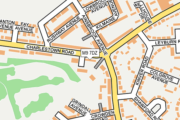
M9 7DZ is located in the Charlestown electoral ward, within the metropolitan district of Manchester and the English Parliamentary constituency of Blackley and Broughton. The Sub Integrated Care Board (ICB) Location is NHS Greater Manchester ICB - 14L and the police force is Greater Manchester. This postcode has been in use since May 1994.


GetTheData
Source: OS OpenMap – Local (Ordnance Survey)
Source: OS VectorMap District (Ordnance Survey)
Licence: Open Government Licence (requires attribution)
| Easting | 387936 |
| Northing | 402872 |
| Latitude | 53.522375 |
| Longitude | -2.183432 |
GetTheData
Source: Open Postcode Geo
Licence: Open Government Licence
| Country | England |
| Postcode District | M9 |
➜ See where M9 is on a map ➜ Where is Manchester? | |
GetTheData
Source: Land Registry Price Paid Data
Licence: Open Government Licence
Elevation or altitude of M9 7DZ as distance above sea level:
| Metres | Feet | |
|---|---|---|
| Elevation | 100m | 328ft |
Elevation is measured from the approximate centre of the postcode, to the nearest point on an OS contour line from OS Terrain 50, which has contour spacing of ten vertical metres.
➜ How high above sea level am I? Find the elevation of your current position using your device's GPS.
GetTheData
Source: Open Postcode Elevation
Licence: Open Government Licence
| Ward | Charlestown |
| Constituency | Blackley And Broughton |
GetTheData
Source: ONS Postcode Database
Licence: Open Government Licence
| Charlestown Rd/Moston Ln (Charlestown Rd) | Charlestown | 24m |
| Charlestown Rd/Moston Ln (Charlestown Rd) | Charlestown | 47m |
| Moston Ln/Charlestown Rd (Moston Ln) | Charlestown | 52m |
| Moston Ln/Shawford Rd (Moston Ln) | Moston | 122m |
| Charlestown Rd/Elaine Ave (Charlestown Rd) | Charlestown | 133m |
| Failsworth (Manchester Metrolink) (Hardman Lane) | Failsworth | 1,888m |
| Moston Station | 0.8km |
| Mills Hill (Manchester) Station | 3.3km |
| Manchester Victoria Station | 5.5km |
GetTheData
Source: NaPTAN
Licence: Open Government Licence
| Percentage of properties with Next Generation Access | 100.0% |
| Percentage of properties with Superfast Broadband | 100.0% |
| Percentage of properties with Ultrafast Broadband | 0.0% |
| Percentage of properties with Full Fibre Broadband | 0.0% |
Superfast Broadband is between 30Mbps and 300Mbps
Ultrafast Broadband is > 300Mbps
| Percentage of properties unable to receive 2Mbps | 0.0% |
| Percentage of properties unable to receive 5Mbps | 0.0% |
| Percentage of properties unable to receive 10Mbps | 0.0% |
| Percentage of properties unable to receive 30Mbps | 0.0% |
GetTheData
Source: Ofcom
Licence: Ofcom Terms of Use (requires attribution)
GetTheData
Source: ONS Postcode Database
Licence: Open Government Licence


➜ Get more ratings from the Food Standards Agency
GetTheData
Source: Food Standards Agency
Licence: FSA terms & conditions
| Last Collection | |||
|---|---|---|---|
| Location | Mon-Fri | Sat | Distance |
| Clayton Bridge P.o. | 17:30 | 12:00 | 264m |
| Horncastle Road | 17:30 | 12:00 | 486m |
| Bluebell | 17:30 | 12:00 | 1,036m |
GetTheData
Source: Dracos
Licence: Creative Commons Attribution-ShareAlike
The below table lists the International Territorial Level (ITL) codes (formerly Nomenclature of Territorial Units for Statistics (NUTS) codes) and Local Administrative Units (LAU) codes for M9 7DZ:
| ITL 1 Code | Name |
|---|---|
| TLD | North West (England) |
| ITL 2 Code | Name |
| TLD3 | Greater Manchester |
| ITL 3 Code | Name |
| TLD33 | Manchester |
| LAU 1 Code | Name |
| E08000003 | Manchester |
GetTheData
Source: ONS Postcode Directory
Licence: Open Government Licence
The below table lists the Census Output Area (OA), Lower Layer Super Output Area (LSOA), and Middle Layer Super Output Area (MSOA) for M9 7DZ:
| Code | Name | |
|---|---|---|
| OA | E00026583 | |
| LSOA | E01005252 | Manchester 003E |
| MSOA | E02001047 | Manchester 003 |
GetTheData
Source: ONS Postcode Directory
Licence: Open Government Licence
| M9 7DA | Hillingdon Drive | 48m |
| M40 5RJ | Moston Lane | 67m |
| M9 7FJ | Ainsbrook Avenue | 89m |
| M40 5RG | Moston Lane | 107m |
| M9 7BS | Charlestown Road | 120m |
| M40 5QX | Ardale Avenue | 125m |
| M9 7FN | Kilmaine Avenue | 134m |
| M9 7GA | Rushway Avenue | 153m |
| M40 5RP | Grindall Avenue | 153m |
| M40 5QQ | Kinver Road | 157m |
GetTheData
Source: Open Postcode Geo; Land Registry Price Paid Data
Licence: Open Government Licence