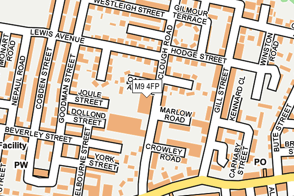
M9 4FP is located in the Harpurhey electoral ward, within the metropolitan district of Manchester and the English Parliamentary constituency of Blackley and Broughton. The Sub Integrated Care Board (ICB) Location is NHS Greater Manchester ICB - 14L and the police force is Greater Manchester. This postcode has been in use since June 2001.


GetTheData
Source: OS OpenMap – Local (Ordnance Survey)
Source: OS VectorMap District (Ordnance Survey)
Licence: Open Government Licence (requires attribution)
| Easting | 386565 |
| Northing | 402091 |
| Latitude | 53.515338 |
| Longitude | -2.204075 |
GetTheData
Source: Open Postcode Geo
Licence: Open Government Licence
| Country | England |
| Postcode District | M9 |
➜ See where M9 is on a map ➜ Where is Manchester? | |
GetTheData
Source: Land Registry Price Paid Data
Licence: Open Government Licence
Elevation or altitude of M9 4FP as distance above sea level:
| Metres | Feet | |
|---|---|---|
| Elevation | 90m | 295ft |
Elevation is measured from the approximate centre of the postcode, to the nearest point on an OS contour line from OS Terrain 50, which has contour spacing of ten vertical metres.
➜ How high above sea level am I? Find the elevation of your current position using your device's GPS.
GetTheData
Source: Open Postcode Elevation
Licence: Open Government Licence
| Ward | Harpurhey |
| Constituency | Blackley And Broughton |
GetTheData
Source: ONS Postcode Database
Licence: Open Government Licence
| Lewis Ave | Blackley | 88m |
| Hodge St | Blackley | 171m |
| Moston Ln/Mowers Arms (Moston Ln) | Moston | 183m |
| Moston Ln/Edward St (Moston Ln) | Moston | 228m |
| Gill St | Blackley | 257m |
| Newton Heath & Moston (Manchester Metrolink) (Dean Lane) | Newton Heath | 1,793m |
| Moston Station | 2.4km |
| Manchester Victoria Station | 4km |
| Mills Hill (Manchester) Station | 4.5km |
GetTheData
Source: NaPTAN
Licence: Open Government Licence
GetTheData
Source: ONS Postcode Database
Licence: Open Government Licence


➜ Get more ratings from the Food Standards Agency
GetTheData
Source: Food Standards Agency
Licence: FSA terms & conditions
| Last Collection | |||
|---|---|---|---|
| Location | Mon-Fri | Sat | Distance |
| Daisybank | 17:30 | 12:00 | 589m |
| Asda | 17:30 | 12:00 | 605m |
| Bluebell | 17:30 | 12:00 | 617m |
GetTheData
Source: Dracos
Licence: Creative Commons Attribution-ShareAlike
The below table lists the International Territorial Level (ITL) codes (formerly Nomenclature of Territorial Units for Statistics (NUTS) codes) and Local Administrative Units (LAU) codes for M9 4FP:
| ITL 1 Code | Name |
|---|---|
| TLD | North West (England) |
| ITL 2 Code | Name |
| TLD3 | Greater Manchester |
| ITL 3 Code | Name |
| TLD33 | Manchester |
| LAU 1 Code | Name |
| E08000003 | Manchester |
GetTheData
Source: ONS Postcode Directory
Licence: Open Government Licence
The below table lists the Census Output Area (OA), Lower Layer Super Output Area (LSOA), and Middle Layer Super Output Area (MSOA) for M9 4FP:
| Code | Name | |
|---|---|---|
| OA | E00026376 | |
| LSOA | E01005207 | Manchester 006D |
| MSOA | E02001050 | Manchester 006 |
GetTheData
Source: ONS Postcode Directory
Licence: Open Government Licence
| M9 4BY | Clough Road | 43m |
| M9 4FG | Carron Avenue | 55m |
| M9 4BX | Clough Road | 63m |
| M9 4FQ | Rossendale Avenue | 75m |
| M9 4EG | Marlow Road | 90m |
| M9 4FW | Hodge Street | 113m |
| M9 4EQ | Clough Road | 115m |
| M9 4FE | Joule Street | 119m |
| M9 4BR | Holmleigh Avenue | 120m |
| M9 4HA | Gill Street | 125m |
GetTheData
Source: Open Postcode Geo; Land Registry Price Paid Data
Licence: Open Government Licence