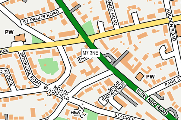
M7 3NE lies on Bury New Road in Salford. M7 3NE is located in the Kersal & Broughton Park electoral ward, within the metropolitan district of Salford and the English Parliamentary constituency of Blackley and Broughton. The Sub Integrated Care Board (ICB) Location is NHS Greater Manchester ICB - 01G and the police force is Greater Manchester. This postcode has been in use since May 1994.


GetTheData
Source: OS OpenMap – Local (Ordnance Survey)
Source: OS VectorMap District (Ordnance Survey)
Licence: Open Government Licence (requires attribution)
| Easting | 382272 |
| Northing | 402002 |
| Latitude | 53.514394 |
| Longitude | -2.268812 |
GetTheData
Source: Open Postcode Geo
Licence: Open Government Licence
| Street | Bury New Road |
| Town/City | Salford |
| Country | England |
| Postcode District | M7 |
➜ See where M7 is on a map ➜ Where is Salford? | |
GetTheData
Source: Land Registry Price Paid Data
Licence: Open Government Licence
Elevation or altitude of M7 3NE as distance above sea level:
| Metres | Feet | |
|---|---|---|
| Elevation | 80m | 262ft |
Elevation is measured from the approximate centre of the postcode, to the nearest point on an OS contour line from OS Terrain 50, which has contour spacing of ten vertical metres.
➜ How high above sea level am I? Find the elevation of your current position using your device's GPS.
GetTheData
Source: Open Postcode Elevation
Licence: Open Government Licence
| Ward | Kersal & Broughton Park |
| Constituency | Blackley And Broughton |
GetTheData
Source: ONS Postcode Database
Licence: Open Government Licence
467, BURY NEW ROAD, SALFORD, M7 3NE 2002 15 MAR £225,000 |
467, BURY NEW ROAD, SALFORD, M7 3NE 2001 4 JUL £250,000 |
GetTheData
Source: HM Land Registry Price Paid Data
Licence: Contains HM Land Registry data © Crown copyright and database right 2025. This data is licensed under the Open Government Licence v3.0.
| Bury New Rd/Moor Ln (Bury New Rd) | Kersal Bar | 40m |
| Bury New Rd/Moor Ln (Bury New Rd) | Kersal Bar | 120m |
| Moor Ln/Church Ln (Moor Ln) | Kersal Bar | 141m |
| Moor Ln/Church Ln (Moor Ln) | Kersal Bar | 170m |
| Nevile Rd (Wbd) (Nevile Road) | Kersal Bar | 180m |
| Bowker Vale (Manchester Metrolink) (Middleton Road) | Bowker Vale | 1,738m |
| Salford Crescent Station | 3.1km |
| Clifton (Manchester) Station | 3.2km |
| Manchester Victoria Station | 3.5km |
GetTheData
Source: NaPTAN
Licence: Open Government Licence
GetTheData
Source: ONS Postcode Database
Licence: Open Government Licence


➜ Get more ratings from the Food Standards Agency
GetTheData
Source: Food Standards Agency
Licence: FSA terms & conditions
| Last Collection | |||
|---|---|---|---|
| Location | Mon-Fri | Sat | Distance |
| Nevil Road | 17:30 | 11:45 | 179m |
| Sedgley Park P.o. | 17:30 | 12:00 | 519m |
| Singleton Road | 17:30 | 11:45 | 523m |
GetTheData
Source: Dracos
Licence: Creative Commons Attribution-ShareAlike
The below table lists the International Territorial Level (ITL) codes (formerly Nomenclature of Territorial Units for Statistics (NUTS) codes) and Local Administrative Units (LAU) codes for M7 3NE:
| ITL 1 Code | Name |
|---|---|
| TLD | North West (England) |
| ITL 2 Code | Name |
| TLD3 | Greater Manchester |
| ITL 3 Code | Name |
| TLD34 | Greater Manchester South West |
| LAU 1 Code | Name |
| E08000006 | Salford |
GetTheData
Source: ONS Postcode Directory
Licence: Open Government Licence
The below table lists the Census Output Area (OA), Lower Layer Super Output Area (LSOA), and Middle Layer Super Output Area (MSOA) for M7 3NE:
| Code | Name | |
|---|---|---|
| OA | E00028585 | |
| LSOA | E01005648 | Salford 011B |
| MSOA | E02001167 | Salford 011 |
GetTheData
Source: ONS Postcode Directory
Licence: Open Government Licence
| M7 3NB | Vine Street | 43m |
| M7 3ND | The Drive | 54m |
| M7 4NS | Kersal Gardens | 90m |
| M7 3AD | Vine Street | 95m |
| M7 3PH | Nevile Road | 102m |
| M7 3WX | Moor Lane | 106m |
| M7 4SL | Kersal Crag | 109m |
| M7 4EP | Jacobite Close | 117m |
| M7 3NF | Moor Lane | 126m |
| M7 4WE | Bury New Road | 159m |
GetTheData
Source: Open Postcode Geo; Land Registry Price Paid Data
Licence: Open Government Licence