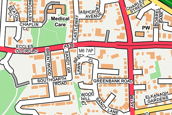
M6 7AP is located in the Weaste & Seedley electoral ward, within the metropolitan district of Salford and the English Parliamentary constituency of Salford and Eccles. The Sub Integrated Care Board (ICB) Location is NHS Greater Manchester ICB - 01G and the police force is Greater Manchester. This postcode has been in use since January 1980.


GetTheData
Source: OS OpenMap – Local (Ordnance Survey)
Source: OS VectorMap District (Ordnance Survey)
Licence: Open Government Licence (requires attribution)
| Easting | 380363 |
| Northing | 399475 |
| Latitude | 53.491612 |
| Longitude | -2.297441 |
GetTheData
Source: Open Postcode Geo
Licence: Open Government Licence
| Country | England |
| Postcode District | M6 |
➜ See where M6 is on a map ➜ Where is Salford? | |
GetTheData
Source: Land Registry Price Paid Data
Licence: Open Government Licence
Elevation or altitude of M6 7AP as distance above sea level:
| Metres | Feet | |
|---|---|---|
| Elevation | 60m | 197ft |
Elevation is measured from the approximate centre of the postcode, to the nearest point on an OS contour line from OS Terrain 50, which has contour spacing of ten vertical metres.
➜ How high above sea level am I? Find the elevation of your current position using your device's GPS.
GetTheData
Source: Open Postcode Elevation
Licence: Open Government Licence
| Ward | Weaste & Seedley |
| Constituency | Salford And Eccles |
GetTheData
Source: ONS Postcode Database
Licence: Open Government Licence
| Eccles Old Rd/Langworthy Rd (Eccles Old Rd) | Pendleton | 85m |
| Eccles Old Rd/Langworthy Rd (Eccles Old Rd) | Seedley | 111m |
| Eccles Old Rd/Brentwood (Eccles Old Rd) | Pendleton | 139m |
| Eccles Old Rd/Chaseley Rd (Eccles Old Rd) | Pendleton | 214m |
| Charles St/Langworthy Rd (Charles St) | Pendleton | 264m |
| Langworthy (Manchester Metrolink) (Eccles New Road) | Langworthy | 1,220m |
| Weaste (Manchester Metrolink) (Eccles New Road) | Weaste | 1,232m |
| Salford Crescent Station | 1.5km |
| Eccles Station | 2.6km |
| Salford Central Station | 3km |
GetTheData
Source: NaPTAN
Licence: Open Government Licence
GetTheData
Source: ONS Postcode Database
Licence: Open Government Licence


➜ Get more ratings from the Food Standards Agency
GetTheData
Source: Food Standards Agency
Licence: FSA terms & conditions
| Last Collection | |||
|---|---|---|---|
| Location | Mon-Fri | Sat | Distance |
| Frederick Road / Winders Way | 18:30 | 608m | |
| 34 Cresent/Hulme Place | 17:30 | 12:00 | 690m |
| Tootal Drive P.o. | 17:30 | 12:00 | 876m |
GetTheData
Source: Dracos
Licence: Creative Commons Attribution-ShareAlike
The below table lists the International Territorial Level (ITL) codes (formerly Nomenclature of Territorial Units for Statistics (NUTS) codes) and Local Administrative Units (LAU) codes for M6 7AP:
| ITL 1 Code | Name |
|---|---|
| TLD | North West (England) |
| ITL 2 Code | Name |
| TLD3 | Greater Manchester |
| ITL 3 Code | Name |
| TLD34 | Greater Manchester South West |
| LAU 1 Code | Name |
| E08000006 | Salford |
GetTheData
Source: ONS Postcode Directory
Licence: Open Government Licence
The below table lists the Census Output Area (OA), Lower Layer Super Output Area (LSOA), and Middle Layer Super Output Area (MSOA) for M6 7AP:
| Code | Name | |
|---|---|---|
| OA | E00028969 | |
| LSOA | E01005721 | Salford 023D |
| MSOA | E02001179 | Salford 023 |
GetTheData
Source: ONS Postcode Directory
Licence: Open Government Licence
| M6 8RA | Eccles Old Road | 79m |
| M6 8QU | Brentwood | 116m |
| M6 8RB | Sandy Lane | 120m |
| M6 7DW | Castleway | 126m |
| M6 8RG | Greenbank Road | 129m |
| M6 7AW | Ashcroft Avenue | 132m |
| M6 8RL | Seedley Terrace | 145m |
| M6 7DJ | Ashcroft Avenue | 154m |
| M6 8RF | Eccles Old Road | 157m |
| M6 7AG | Langworthy Road | 167m |
GetTheData
Source: Open Postcode Geo; Land Registry Price Paid Data
Licence: Open Government Licence